
The commencement of the construction of the Grand Canal in the late 1750s, brought with it the expansion of trade. Goods could be carried to Dublin in the east and from Edenderry to Shannon Harbour in the west and helped boost the development of the local economy from the early 1800s. We are starting an exploration of the townlands along the canal in County Offaly starting at the border with Kildare. You are invited to contribute with memories, stories, and pictures (info@offalyhistory.com).
The Offaly section of the canal runs approximately 43 miles and is home to a number of species and wild plants, due to the cross over through wet bogland during the development of the canal way[1].

(01.Illustration: Book, Nature on Irish Canals by Brid Johnson and Marie Dromey, The Stationery Office, Pp1-
Today with the canal being a popular walking destination, you can see along the canals, a variety of wildlife from rabbits, fox, birds and fish. The still water is also ideal for boat cruising and canoeing, and is one of the major fishing destination during the summer months. While using the many locks and bridges as walking points along the way.
The Grand Canal is filled with many stories and hidden secrets. Let’s have a look back to the beginning, to unlock some of its historical events and facts associated with the townlands along the Grand Canal way. You never know what you might discover!
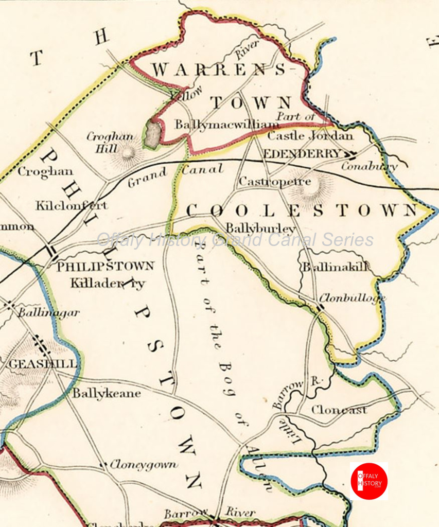
Edenderry:
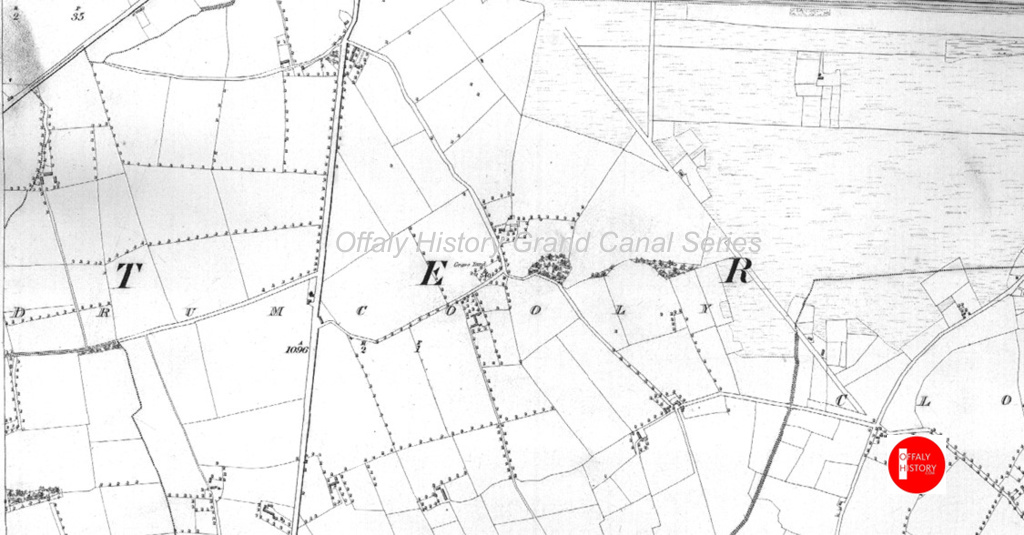
In the east of County Offaly, meaning “Brow of (the) oak-wood” the Grand Canal runs along the south side of Edenderry. Cloncanon, is the first townlands that the Grand Canal runs alongside, in the Edenderry division: Barony: Coolestown, Parish: Monasteroris.
Cloncanon is in the Electoral Division of Edenderry Rural, in Civil Parish of Monasteroris, in the Barony of Coolestown, in the County of Offaly.
The Irish name for Cloncanon is Cluain Canann meaning Field of the pup. An earlier alternative meaning of Cloncanon was Claine Ceannine meaning Field of the White faced Cow which was translated by John O’ Donovan.

(Image Source: Offaly OS map Offaly History.ie)
In this townland you will find a small Standing stone located in this townland, the origin is unknown. These Stones normally stand in an upright position. The purpose of these stones was to mark a burial or a ritual. Some of these stones can date back much earlier.
Cloncanon, is situated in the parish of Monasteroris, also known as Mainistir Fheorais, named after the Monastery of Mac Fheorais. The Civil Parish is located in the ancient territory of Upper Tethmoy, the Irish Tuath dha Muighe Uachtar meaning Upper land between Two Plains.
Population and housing in Cloncanon, 1841–1911, area 961 acres
| Townland | Population in 1841 | Population in 1851 | No. Of Houses in 1841 | No. Of Houses in 1851 | Population in 1871 | Population in 1911 | No. Of Houses in 1871 | No. Of Houses in 1911 |
| Cloncannon | 209 | 228 | 39 | 39 | 134 | 126 | 28 | 32 |

(Image Source: census of Ireland.com) Summary for Cloncanon in 1911
During the 1911 census, the household returns and ancillary, shows us that during this time Cloncanon had 17 building that consisted of all private dwellings, with 3rd class houses making up the majority during this time, with the head of each family reading as followed, O,Neill, Burke, Baker, Farrell, Dunne, with the youngest recorded at 1 years old and the oldest at 81. The population in 1911 was almost half that in 1841.
During the construction of the canal, Edenderry went through a few trials and tribulations during the planning stage, with delays, lost labour due to the frequent issues with bog and major breaks in the bank, thought-out the periods of 1820-1989. The minute books of the 1790s and early 1800s (NAI) are replete with the problems of the Blundell Aqueduct.
Eventually, all early obstacles were navigated and the construction of the canal was completed in 1797. In 1802, the Cut to Edenderry was finished and the branchline and harbour , financed by Lord Downshire costing £692 completed. Edenderry and the surrounding lands has passed from the Blundells to the Downshires (see blog on Saturday 17 Feb).
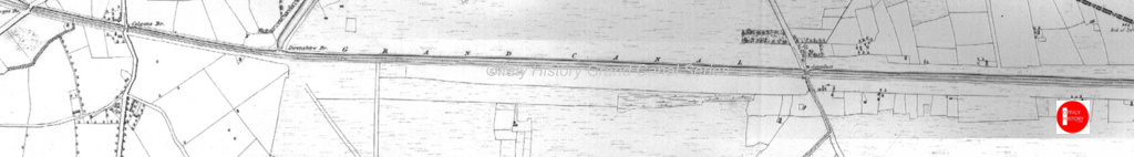
(Along the Grand Canal line Downshire Bridge and Blundell Aqueduct/Image Source: Offaly History.ie)

(02.Cloncanon, Source: Townlands.ie)

(Cloncanon, Source: http://www.logainm.ie
(Cloncanon, Source: http://www.logainm.ie)
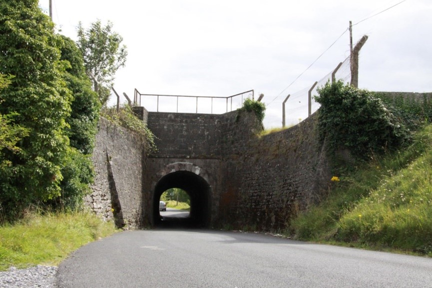
The Tunnel
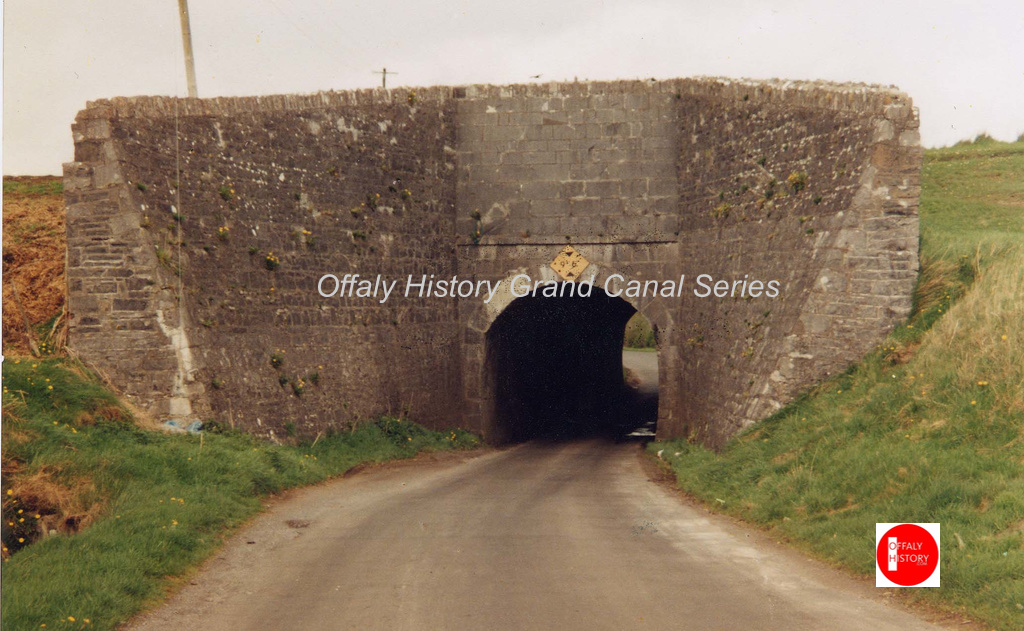
(03. The Tunnel, or Blundell Aqueduct, Source: Offaly History Centre)
The water flow through a man-made culvert and flows down into a stream, which goes into the Boyne. The curved base was designed to accommodate for the construction of the culvert on this aqueduct. This amazing construction of engineering still continuing to stand tall, 200 years on.
A hump backed bridge, known as Downshire Bridge is the only feature along the line and it is the narrowest of all the canal bridges that run along the Offaly section of the Grand Canal. It was constructed at the time, to take the necessary flow of horses, who were to tow the barges. You can still see today the deep grooves left by towing ropes in the sides of the Bridges[2].
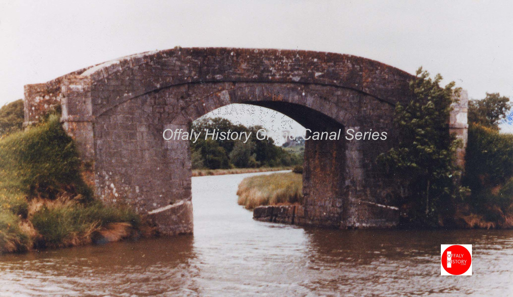
(no 4. Above Illustration/photo of Downshire Bridge, Source, Offaly History Centre.)

(No5.On the left a photo showing the deep grooves of the ropes, Source, Offaly History Centre.)
Drumcooly
Going Along we come to Drumcooly, on the south side of the canal. Electoral Division of Edenderry Rural, in Civil Parish of Monasteroris, in the Barony of Coolestown, in the County of Offaly. The Irish name for Drumcooly is Droim Cúile meaning Corner Ridge.
(Image Source: Offaly OS map Offaly History.ie)
In this townland you will find a Graveyard and the remains of a possible site of a Church, Grass covering two wall are left and can be seen today. Along with this, there is an impressive Motte and Bailey, situated in the town. The motte is 27 metres in diameter and is enclosed by the remains of a fosse. The Bailey is D in shape and is enclosed by an earthen bank on its West side.
Area, Population and number of houses in Drumcooly, 1841 to 1911, area 1,096 acres
| Townland | Population in 1841 | Population in 1851 | No. of Houses in 1841 | No. of Houses in 1851 | Population in 1871 | Population in 1911 | No. of Houses in 1871 | No. of Houses in 1911 |
| Drumcooly | 182 | 185 | 28 | 29 | 125 | 90 | 24 | 27 |
Surprisingly the population and number of houses held up in the Famine years with no 25% or more reduction as was common in other townlands. By 1911 it was down by half but with the same number of houses.
Both townlands of Cloncanon and Drumcooly are in the civil parish of Monasteroris, area 15,762 acres, population in 1841 was 2,321 and 2,057 in 1851. The number of houses in the same period was 398 falling to 376 in 1851. These figures exclude Edenderry town where there was no change in the town population but the workhouse that opened in 1842 housed 1,023 in 1851. Clonsast civil parish also in Warrenstown barony by contrast fell by 25%. The biggest decline was in west Offaly which we will come to later in this townland series.

(Image Source: census of Ireland.com). Drumcooly occupiers in 1901
In the 1901 census, the household returns and ancillary, shows in Drumcooly that during this period there was 17 Private dwellings, mostly 2nd class houses with three 1st class houses, of these, 16 were inhabited. Families that occupied these dwelling during this time, were as followed: Byrne, Carey, Carroll, Collins, Cullen, Curran, Delany, Dunne, English, Fennin, Fury, Glennon, Hadgins, Homan, Kenny, Lynch, O’Brien, Shaughnessy, Sheil, Swards, Ussher, Watson.
The youngest person on record at the time, born into the Cullen family, 1 years old female, The oldest being 75 year old Peter Fury, who’s family consisted of two sons, one daughter and a niece.

(photo above Drumcooly townland, where it sit along the Grand Canal. Image source, Townland.ie, Offaly history)
There are many points of interest when going along the Edenderry line, the bridges along the way are some of these features, Colgan’s Bridge and George’s Bridge, this bridge, is a more modern structure, replacing a curved bridge in the late 1960s. It has just enough room for a boat to pass underneath.
During the early 1800s in the period where passenger boats were starting to be used as a way of transport from the townlands, some of these bridges where used as rest spots along the way, Colgan’s Bridge, was used as one of these rest stop, A man called Colgan, owned a rest house, beside the bridge where boatmen and passengers during a long journey could wait, some boat trips could take up to 12 hours.

.On the left a photo showing Colgan’s Bridge, Image source Safe Harbour, The Grand Canal at Edenderry)
If any passenger was carried beyond their stopping destination, the captain of that boat and owner of the rest house at that rest stop, were heavily sanctioned. Colgan found this out the hard way when he didn’t keep the waterway room open for the night boat and had his allowance withdrawn[3]
Many bridges can be used as a beginning or finishing point for walks, below show the distance between each bridge that can be found, from Clocanon to Drumcooly.
Blundell Aqueduct to Downshire Bridge is approximately (2.4km)
Downshire Bridge to Colgans’ Bridge is (.4km)
Colgan’s Bridge to George’s Bridge (.8km)
Moving further down the line you will also come across Rathmore Bridge, which will be covered in more detail in our next Grand Canal Townlands East to West blog series, along with townlands Rathmore, Ballcolgan and Rogertown, we will also look at “Traveling by passenger boat”.
Historical references for Drumcooly
| 1550 | Aaghbeallacoyllane, Aghbeallagreallaghe | Offaly Survey |
| 1550 | Drumcowke | Offaly Survey |
| 1550 | Fynnemonen, Laaghfynnemonen | Offaly Survey |
| 1550 | Klegnecoggerie | Offaly Survey |
| 1550 | Rathendonne | Offaly Survey |
| 1551 | Drumcule | F Leathanach: 691 |
| 1558c | Drumcowle | P.R.O.L. Leathanach: 63/7 |
| 1563c | (Cowly) | Cotton Map |
| 1563c | Drùcowley | Cotton Map |
| 1563 | Dromcowley | F Leathanach: 474 |
| 1569 | Dromcolley | F Leathanach: 1347 |
| 1597 | Drom Colly | F Leathanach: 6078 |
| 1618 | Dromcolley | CPR Leathanach: 367 |
| 1619 | Dromcooley otherwise Drumcolly | CPR Leathanach: 444 |
| 1659 | Drumcally | Cen. Leathanach: 436 |
| 1660c | Drumcooley | BSD (UF) Leathanach: 14 |
| 1783 | Drumcouly | Taylor (Cill Dara) |
| 1837 | Drumcooly | BS:AL |
| 1837 | Drumcooly | Co. Schedule:AL |
| 1837 | Drumcooley | HCER 1826:AL |
| 1837 | Drumcooley | Murray Rental:AL |
| 1837 | Druim Cúile | OD:AL |
| 1837 | Drumcooly | S&V:AL |
| 1837 | Drumcooley | Stat. Surv.:AL |

[1] See “Nature on Irish Canals” Brid Johnson and Marie Dromey, The stationery Office, Pp1-2
[2] See “Safe Harbour, The Grand Canal at Edenderry” Mairead Evans & Therese Abbott” Topic Newspapers Ltd, Pp1-9
[3] See “Safe Harbour, The Grand Canal at Edenderry” Mairead Evans & Therese Abbott” Topic Newspapers Ltd, Pp30-33
