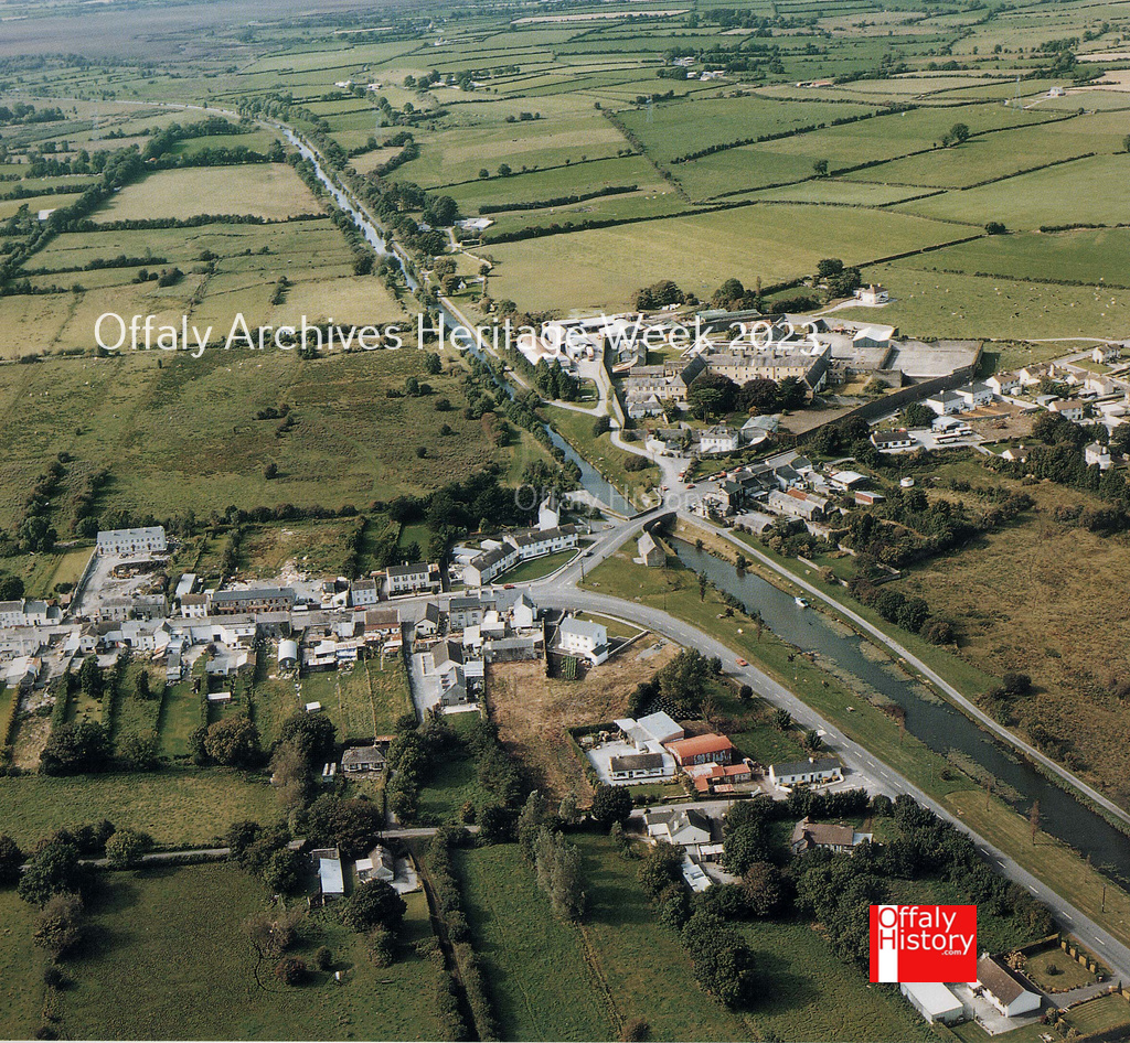
The Grand Canal was constructed as far as Philipstown/ Daingean in 1797 providing the town with an opportunity to import goods at lower transport costs and to export turf and agricultural products to the city of Dublin.
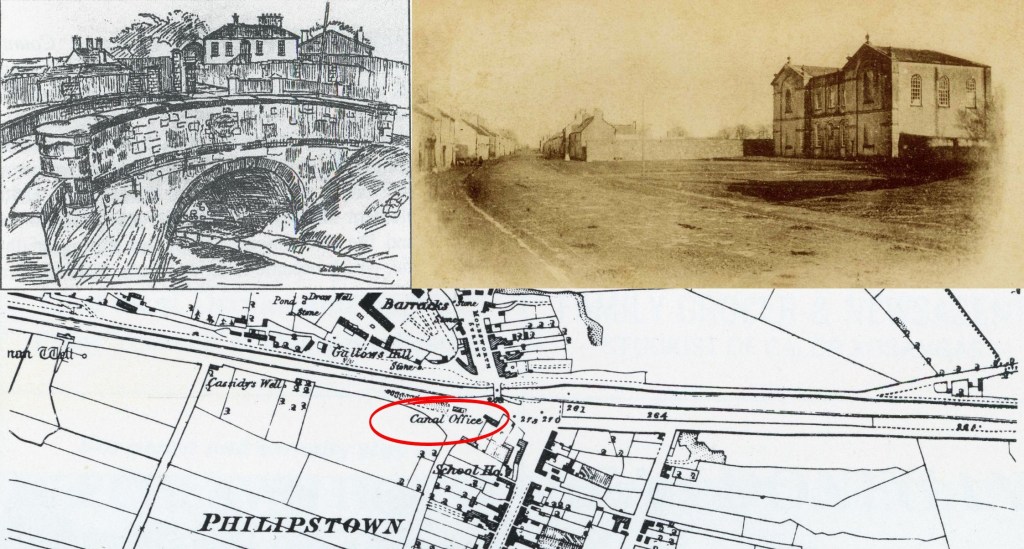
Some immediate benefits came with the canal such as the large house (formerly Scully’s) on the western side of the Molesworth bridge and later the canal warehouse on the eastern side. This was described on the Killaly 1806-7 map as the collector’s house. The trade and stores business moved on to Tullamore exclusively for the six years pending the completion of the access to Shannon Harbour in 1804. The need for a canal hotel was eliminated with the building of the Tullamore hotel in 1801-2 and that at Shannon Harbour in 1806.
The line of the canal ran from Toberdaly to Killaderry parish, the townland of Castlebarnagh Big and into the town of Daingean. From there is passed on to Ballymullen and Ballycommon. As with Tullamore the canal came in on the north side of the town cutting through cabins in its way to the south of the military barracks and gallows hill. In the estate landscape that it was in the 1700s to the 1900s the big houses of Mount Briscoe, Clonearl and Kilduff were to the north and Springfield, Mount Lucas and the lost demesne of River Lyons to the south. The latter was almost devoid of trees unlike the well planted Clonearl and the planted avenue to the house at Mount Briscoe. On the southwest was the old crossing point of Ballinagar heading on to Tullamore.
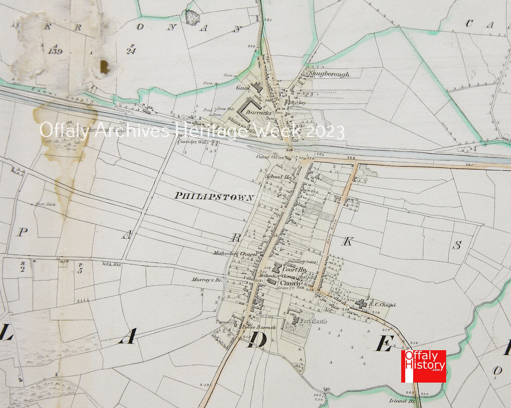
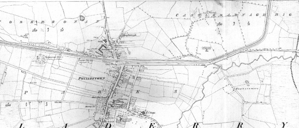
The overview is best provided in Larkin’s 1809 map and the index sheet to the six-inch scale maps of the Ordnance Survey of 1838. The Larkin map shows the windmill at Castlebarnagh and the layout of the town with its barracks, new courthouse, church, the old courthouse and the long street running north to the new Molesworth Street beyond the Molesworth bridge dated to 1796. In August last year, as part of Heritage Week, we looked at the newly conserved map of Daingean and the Molesworth estate in 1786. The map was donated to Offaly Archives and conserved thanks to a grant from the Heritage Council.

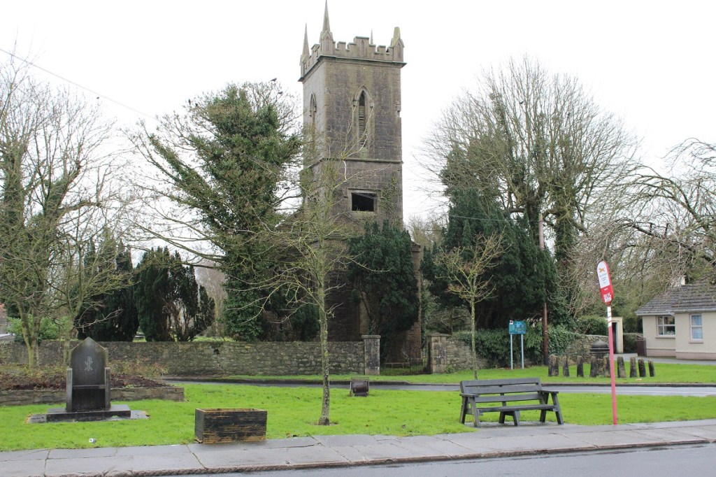
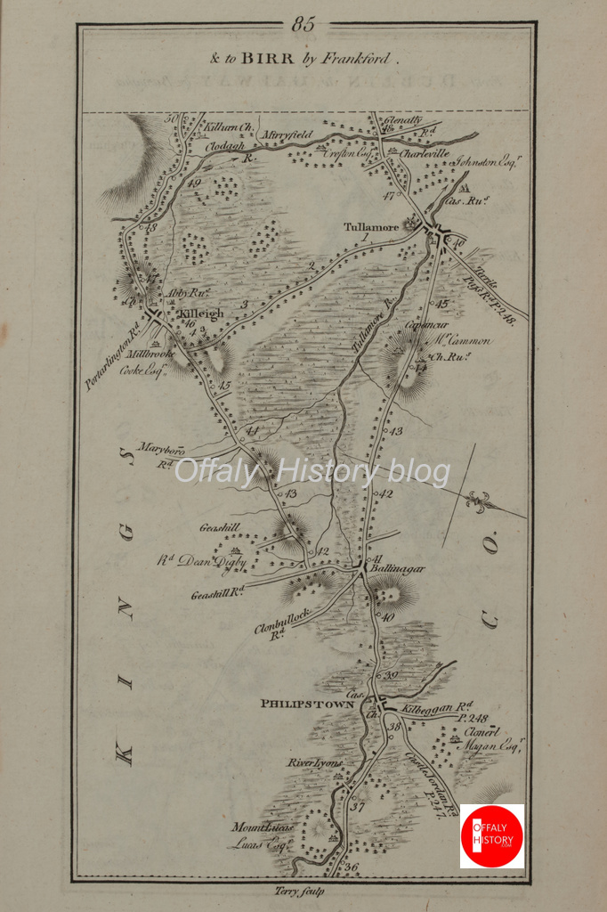
The outline of Philipstown/Daingean on the Taylor and Skinner map of 1777 shows the Protestant church and the town. The curious shape north of the church on the map is the old fort marked as Cas. which was then falling to ruin but was refurbished in the early nineteenth century. The old courthouse of the 1760s was in the immediate vicinity of what was Brady’s shop (see earlier blogs on this). The estate houses at River Lyons, Clonearl and Mount Lucas are marked as are the milestones from Dublin, numbers 37, 38 and 39. Also to be seen on that sheet of Taylor & Skinner is the Geashill rectory of Dean Digby, Ballinagar, Killeigh and Tullamore. The Killeigh and Daingean Roads are shown but not that from Geashill.
A better picture of the housing stock in Daingean almost 240 years ago comes into view with the Neville map of the Molesworth estate, Daingean in 1786. Molesworth’s Daingean estate was small at almost 3,000 acres when compared with that of Downshire at Edenderry (14,000 acres); Digby at Geashill (30,000), and Lord Tullamore’s at Croghan and Tullamore (20,000 acres). The division of ownership into three parts soon after was not good for the development of Daingean.
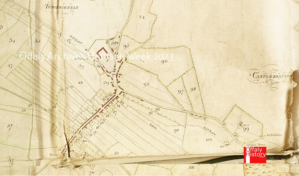
A previous owner of the Moleworth 1786 map marked in the outline of the ‘canal for the Shannon’. The windmill is marked near the Dublin Road at Castlebarnagh Big, and a mill and mill race to the south of it with perhaps 15 cabins west of Castlebarnagh. The plots 36, 39, 94. 93, 97, 98 and 99 on the 1786 map were all in the route of the canal with the lessees Charles Brickland, the barracks and Richard Scully to be compensated for disturbance and loss together with Walter Delmer, Molesworth or his heirs (the street and the freehold reversion) and the mill owner. The town was comprised of about 50 plots or leaseholds – numbers 38-58 and 69-99.
Coote in his survey of the county in 1800 observed that:
‘This country is very thickly inhabited; Philipstown which is the county town, and the only one in the barony, has hitherto sent two members to parliament; it has till lately been in a wretched state, and was rapidly fallen to ruin: now there is but little to recommend it. This town was originally part of the Molesworth estate, and, through family connections, is now divided into three properties; the most considerable part of it is enjoyed by the Right Honourable Mr. Ponsonby. The new leases now given are encouraging, and several new houses are erecting. The Grand canal passes at the northern end of the town, and, before this navigation, was complete to Tullamore, it was of very material service to this town, but now of inconsiderable advantage. A new county gaol is also erecting at the rear of the barracks, which are extensive, and command the town: it is almost entirely surrounded with bog, consequently fuel must be cheap and abundant; and provisions are in plenty, yet no manufacture of any kind is carried on.
On the 1838 map the Castlebarnagh windmill is marked as in ruins. Gallows Hill and the barracks are marked as is the new county gaol of c. 1900. On the east side of Molesworth Street are five to seven leasehold properties with upwards of twenty cabins on the Clonearl and Kiladerry roads north of the town. The Scully family appeared to control the canal house property on the town side of the canal.
J. Binns in his visit to Daingean in 1836 recounted meeting a Patrick Ennis who was selling seven or eight boatloads of turf per season as up to £8 a load.
We visited also Patrick Innis, who has a farm of 40 acres, on an island on the bog, at a rent of 15s. per acre. The soil is six or seven inches deep, on a substratum of stiff clay. He digs in the wheat – that is, he sows it on the surface, and afterwards digs out the furrows to cover it, and has a better crop than if it were harrowed in. The produce is from four to five barrels of wheat, and five barrels of oats per acre. His plough was a very clumsy implement, with a patched wooden mould-board. Innis keeps five cows; but knows nothing of green crops. He told us that he should be very glad to learn, but had nobody to put him in the way. How valuable to this man, and to thousands such, might one of Blacker’s pamphlets on small farms prove! [Blacker was a model farmer – estate agent. See my earlier article on the Tullamore Agriculture Show.] His mother, his wife, and thirteen children, live under his humble roof, and his boys work the farm, and assist in getting turf, of which he sends seven or eight boat-loads in the season to Dublin, by the Grand Canal, which passes close to his farm. The boat-loads are worth seven or £8 each. Tithe he has not paid for the last three years; indeed he declared that he durst not pay it, even if he wished, as his property would be burnt, in the event of his doing so.

Binns did not hold out much prospect for improvement. Of the town he wrote:
The town is well built and was formerly a place of note. It contains a capital Court-house and Prison, a large Catholic chapel, and a small Protestant church. The Grand Canal, on which two passage-boats ply daily between Dublin and the Shannon harbour, adjoins the town. Previously to the Union, [1800] Philipstown returned two members to parliament, and was a place of considerable trade. Lamentably, however, are things changed now. It is robbed of its representatives – the assizes are removed to Tullamore – its trade has disappeared – many of its houses are in ruins – its shops are falling into decay – and its population, as these signs sufficiently indicate, are poor and wretched. Although surrounded by miles of unreclaimed bog land, its inhabitants wander about the streets in search of employment, and find none. Nor is the desolation confined to the town. In a walk along the bog towards Dublin, we observed the roofless walls of a superb mansion, formerly the residence of Henry Lyons, Esq., one of the representatives of the county [River Lyons] There are several places which bear the name of Inns or Hotels. We took up our abode at the south end of the town, at an hotel kept by Mrs. Ellis, the post-mistress [now Brady’s] Here – after sufficient time to procure tea and coffee from Dublin had elapsed – we lived very comfortably; regaling ourselves in the meantime with excellent cream and eggs, and a joint, occasionally, of good beef or mutton. The chickens, like the generality of Irish poultry, were half starved.
Thanks to Comerford’s History of Kildare & Leighlin diocese Philipstown has surviving estimates of population for the 1760s (Comerford, 2: 303-4); see also Gurrin and ors, The Irish religious censuses of the 1760s, pp 17-18. Killaderry (Philipstown) civil parish had 1,492 people and Kilclonfert 708 in the 1760s. Ballycommon at the time was said to have 98 Protestants, 6 Presbyterians and 490 Catholics. A total of c. 2,800 in the barony of Lower Philipstown. By the time of the 1813 census the estimate for the barony was 7,734. Philipstown had almost 2,000 people in 1821 when the population of the adjoining commons is included. Source Horner, Mapping Offaly and 1821 census. In 1841 the population of the barony was 7,223 and in 1851 5,320. Philipstown fell from 1,489 to 748 in the same ten years, bearing out the observations of Mr Binns (1836) about poverty in the town and also the Vallancey comments of 1771 and Coote’s comments of 1800.