Father Grogan was born on June 14th, 1873, in Brocca, Screggan County in Offaly. His parents were Joseph Grogan and Mary Molloy. He received his early education at Mucklagh National School, Saint Columbus School, Tullamore and Saint Finian’s College Navan. At the solicitation of his uncle, the Reverend, Anthony J. Molloy of the New York Archdiocese, came to the United States and was admitted to Saint Joseph Seminary then located in Troy, New York. He continued his studies there and at the new St. John’s Seminary in Dunwoody, where he was ordained on May 27th, 1899. He celebrated his first mass at Saint Peter’s church in Yonkers, NY, where his uncle was the Past
His first assignment was to Rosendale, NY for one year. He was transferred to the Mission of Our Lady of the Rosary, where he remained uninterruptedly serving as assistant until 1922.
Neville’s Atlas of the 3,000-acre estate at Philipstown in 1786 has not before been seen by the public and has probably not been consulted for fifty years. The surveyor was Arthur Richards Neville who was Dublin City Surveyor, 1801-1828 and he prepared the map on the instructions of the Molesworth Estate, the owner of 3,000 acres including the town of Daingean. Neville was in practice as a land surveyor from the 1780s or earlier. He succeeded RICHARD BURLEIGH WORTHINGTON as City Surveyor in 1801. He retained the post until his death in 1828 when he was succeeded by his son ARTHUR NEVILLE(Dictionary of Irish Architects online). The map is 154×128 cm and is 20 perch to the inch, taking in almost 3,000 statute acres and 130 land holdings. The map was conserved with the support of a grant from the Heritage Council. The map was donated to Offaly Archives in 2022. Our thanks to Arnold Horner for his assistance.
To mark Heritage Week 2023 we have two articles on St Catherine’s Church, Hop Hill, Tullamore. This week the background from the 1700s to the completion of the new church in 1815. When coming to Tullamore by boat or rail the two most prominent sites to greet the visitor are the spire of the Catholic church completed in 1906 and that of St Catherine’s church, built on the mound known as Hop Hill and completed in August 1815.
We take the presence of the Cof I churches of St Catherine’s, Clara, Shinrone, Geashill, Edenderry and St Brendan’s in Birr (to name a few) for granted. The upkeep is great and the contributors few.More will need to be done to structure support for the upkeep of these buildings.
A Francis Johnston plan with the burial crypt of c. 1808-10. Courtesy of the Irish Architectural Archive
Hop Hill site a brave choice
The Hop Hill site was a brave choice as there was work to be done to make it suitable for building and the adjoining ground was soft and prone to flood, especially in the years before the two Brosna drainage schemes of 1850 and 1950. The Tullamore town landlord, Charles William Bury (1764-1835), had reserved the large distillery plot (now the Granary apartments in Market Square) for a church, from about 1800 to 1806. In the latter year then rector, Ponsonby Gouldsbury, and the vestry opted for the Hop Hill site and the new church was largely completed in August 1815. Soon after the old church off Church Street, erected in 1726, was demolished and the site of the church and, possibly an adjoining graveyard, were used for the Shambles or meat market and the remaining land incorporated into the new Market Square or Corn Market. The new Bachelors Walk was worked on from about 1812 as an attractive avenue to the new church from the High Street and from the town’s owner’s new residence, Charleville Castle. The architect for the church was Francis Johnston and for the new avenue, or Bachelors Walk was John Claudius Loudon, the distinguished landscape architect and designer of demesnes.
The young Charles William Bury when aged 28 and just seven years into his estate. He married in 1798 and died in 1835. His best years were up to the completion of the castle. He contributed about £4,000 of the £8,000 it cost to build St Catherine’s.(more…)
The Tullamore and County Offaly Agricultural Show may be described as a unique cross urban/rural community undertaking and a traditional family day out attracting up to 60,000 people to the show. The Tullamore show was rekindled in 1991 by a small group of local people representing urban and rural communities. The Tullamore and Co. Offaly Agricultural Show Society Ltd was founded in 1990 and since its inception the Tullamore Show has grown to become one of Ireland’s largest and finest one day shows with entries from the 32 counties. In the early years of the 1990s the Tullamore Show was held in the grounds of Charleville demesne and castle in the month of August.
A 2018 show launch courtesy of the Show Gallery(more…)
If walls could talk and archives survived, what would we learn about GV no. 48 High Street, Tullamore. A lot over its 275-year history so far. The number in the first printed valuation map of 1854 was no. 48. It is convenient to use this as the street was built by 1820, except for the Presbyterian church of 1865.
O’Connor Square and High Street were the principal streets in Tullamore from the 1740s to the 1960s. Charles Moore, the second Lord Tullamore, and from 1757 to his death in 1764 earl of Charleville, gave leases for substantial houses in High Street and these included the former Motor Works, the Round House, Mr Price building and Colonel Crow’s (no GV 48).
Most of the surviving houses in High Street date from the 1740s to the first fifteen years of the 1800s. Yet there is evidence of the commencement of a street here from 1713 with the building of houses GV 1, 2 and 3, followed in the 1740s and 1750s by GV 4, (O’Connor Square west for our purposes, from Bridge Centre entrance to the G.N. Walshe shop) and GV 5 and 6 High Street (Conway and Kearney and Guy Clothing). Both the northern and southern ends of High Street face important open spaces: the northern end forms the west side of O’Connor Square, and the southern end broadens out to form a triangular open space at the junction of O’Moore Street and Cormac Street.
High Street has been known by its present name since the early 1700s. However, until the early-nineteenth century High Street also included what is now Bridge Street. The street is uniformly wide throughout even allowing for the fact that some of the houses had railed-in areas to the front. Most of these, but not all, were destroyed by the 1970s.
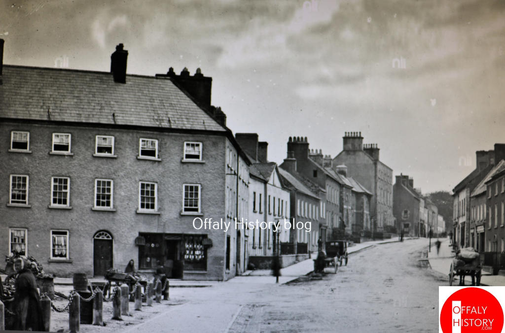
This photograph of O’Connor Square and High Street was taken about 1900, or a little earlier (and preserved courtesy of the National Library) and shows the fine corner building erected by the distiller Joseph Flanagan in 1787 with its original glazing bar/windows and Georgian doorcases. This is the large building from the former Willie and Mary Dunne’s shop (GV 49) to the William Hill bookmaker’s office, beside Gray Cunniffe Insurance. Like the Adams-Tullamore House at the junction of O’Moore Street and Cormac Street it is a substantial three-storey house closing off the square on the southern side with some ten bays to O’Connor Square and six to High Street. The building was carefully planned as can be seen from this lovely old photograph, courtesy of the National Library of Ireland. This is the earliest surviving view of the building. South of it is no. 48 (with carriage outside).
Col. Crow’s is a fine three-storey, seven-bay house with a Gibbsian door-case and open-bed pediment. The building, for many years known as Colton’s Hotel, has now two shopfronts and the original railings and low wall fronting the basement were removed in the mid-1970s.The building has lost its original glazing bars. From the early Lawrence photograph of c. 1900 we can see that a third storey was added soon after the existing hotel was purchased by Abraham Colton. It was then that a pediment to the roofline was removed and the third floor added. It was not so unusual to add a floor and there are examples of it in Columcille Street with Galvin’s and Dolan’s.
This house was built in 1750 for Colonel Thomas Crowe and survived intact until about 1974. Part of the large garden was used in the building of the Rose Lawn housing scheme in the late 1980s. The house to the south was demolished in 1940 to make way for the new Ritz Cinema, opened in 1946 and demolished in 1980. Roselawn of 21 houses was completed about 1990.
Please see an invitation from the community in Lemanaghan about two events this Saturday 12 August as part of Heritage Week. We are publishing early this week as part of our Heritage Week Specials from 12 to 20 August. So keep in touch with us on Social Media and do call to Offaly History Centre and Offaly Archives as part of next week’s 2023 programme.
The community of Lemanagahan extend a special invitation to you for a truly remarkable event – the book launch of “The Annals of Clonmacnoise” where the links with Lemanaghan will be discussed by the author Nollaig Ó Muraíle. Event Details: Date: Saturday, August 12th, 2023 Time: 2:30 PM Venue: The Granary, Boher, Ballycumber, Offaly, N35NX30 [beside St. Manchans Church]
“The Annals of Clonmacnoise” is a meticulously compiled chronicle that offers a panoramic view of Ireland’s past. Through its pages, you’ll be transported to a world of ancient tales, historical intrigue, and cultural treasures that have shaped the very essence of our heritage.
The abolition of Tullamore Town Council in 2014 evoked many memories for me of my years covering that body and its predecessor, Tullamore Urban District Council (UDC) from 1988 to 2007 for the Offaly Express, and for a year and a half before that for the Offaly Independent. I also covered a number of meetings as a freelancer for the Express following my ill-fated return from England.
When I first covered the council, I had the advantage of knowing all the councillors. Six of those early councillors are now deceased – Ernie McGuire and Lar Byrne of Labour, Billy Bracken of Fine Gael (FG), Ann Fox of Fianna Fáil (FF) and independent representatives May Keeley (who, in 1974, was the first woman ever elected as a councillor in Tullamore) and Anne O’Toole.
This week, in part 2 of his article on Mag Léna, John Dolan covers another split and a far more important event than a battle in Mag Léna. This synod was just one matter in a significant dispute between the Irish or Celtic church and Rome in the 7th and 8th centuries.
Background
The expansion of the Christian church out of Jerusalem was based on the infrastructure and administration structures of the Roman Empire. Building Roman roads throughout the empire to assist military and trade movement allowed Christians to expand and base themselves in cities. Christianity was just one religion that was practiced in the empire. Christianity developed in an urban setting with bishops based in cities.
Gildas dates the arrival of Christianity to England by 1st century. Bede tells us that in 156AD King Lucius of the Britons sought Christian instruction from Pope Eleutherus and that ‘this request was quickly granted, and the Britons received the faith and held it peacefully in all its purity and fullness until the time of Diocletian’. But by 303 – 312AD Diocletian was persecuting Christians in England by blaming them for military failures. By 380AD Christianity was recognised as the official religion of the empire.
Mag Léna is of interest for two events that occurred in the early historic period. The first event is the pseudo historic Battle of Mag Léna. The second event was the significant Synod of Mag Léna and the Letter of Cummain, part of the Irish church row with Rome over the dating of Easter.
Both incidents caused a split in Ireland!
What’s in a name?
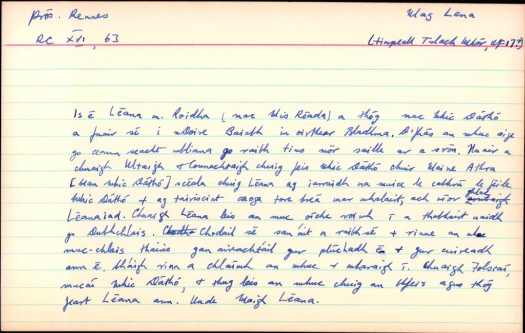
Mag Léna is mentioned in logainm.ie as Moylena and places it in the parish of Kilbride, Co. Offaly. Mag or Magh translates as a plain or open country, there is no information provided on the meaning of the word Léna. Unusually, there are no additional references other than the basic location details, also this older relic from the original card index system below. A 13th century manuscript mentions Cath Mhuighe Léana. Magh Léana is mentioned elsewhere. In his Survey Letters we find O’Donovan used a variety of spellings for the name – Moylena, Moyléna, Moyleana, Moleany and Moy-leana.
Logainm index card for Mag Léna.
As usual there are difficulties with the older Gaelic placenames and how they were recorded over time. Today the only memory of the name is in Tullamore, where the Moylena road joins the Clara Road and eventually joins the Rahan Road through Glendaniel.
The dismantling of the barrack structure of the British military establishment advanced rapidly in the aftermath of the signing of Anglo-Irish Treaty in December 1921. The great exodus in Offaly began in February 1922. The newly issued Offaly Independent (absent since November 1920 due to its destruction by the British military) was now able to report that
11 March 1922 Offaly Independent
, “They are going with a vengeance,” but now it is the army of occupation, not the natives of the country, that is leaving our shores, going while a great sigh of relief goes up, and no pang of regret is felt at the departure of those who held is in bondage for so long. What a change the front of St. Conleth’s School in Daingean now presents from what it did a short time ago. The front gates are now thrown open for the first time in nearly two years, as when the local police barrack was destroyed the splendid group of houses inside the gates of St. Conleth’s School which had been used for the purpose of housing some of the tradesmen employed in the institution were commandeered and used as a barrack for police and Black and Tans until Wednesday of last week when the evacuation took place. From an early hour on that morning the residents of the barracks were astir and it was easy to see that something out of the common was about to take place. Before long it was evident that the long-wished for hour had come and that the Crown forces were about to clear out, bag and baggage. At mid-day lorries arrived from Edenderry carrying the Black and Tans from that district, and all assembled at the Grand Canal Bridge, Daingean for the final parting. Such musical instruments as accordions, mouthorgans, etc., were produced and the disbanded heroes made the welcome ring to the strains of “Come back to Erin” (we hope they won’t). “It’s a long way to Tipperary”, “You’ll Remember Me”, and other items. The townspeople viewed the scene unmoved and the farewells were not returned. On the following day the members of the old R.I.C. force prepared to leave Daingean, and by Friday not a single policeman was to be seen in the place, while a new force guarded the town (OI, 11 2 1922).