Kilgortin is in the Electoral Division of Rahan, in Civil Parish of Rahan, this parish is situated in the ancient O’Molloy territory of Fear Ceall meaning the mem of the woods or men of the churches. If you look closely along the line in this area you will see deposits of brick clays along the Grand Canal between Ballycowan and Rahan, this was the source of an energetic brick industry in the past. In this part of Rahan you will find the site of Rahan Monastic Centre, this is the most famous archaeological site in this location. It was a very important aspect of Early Christian period.
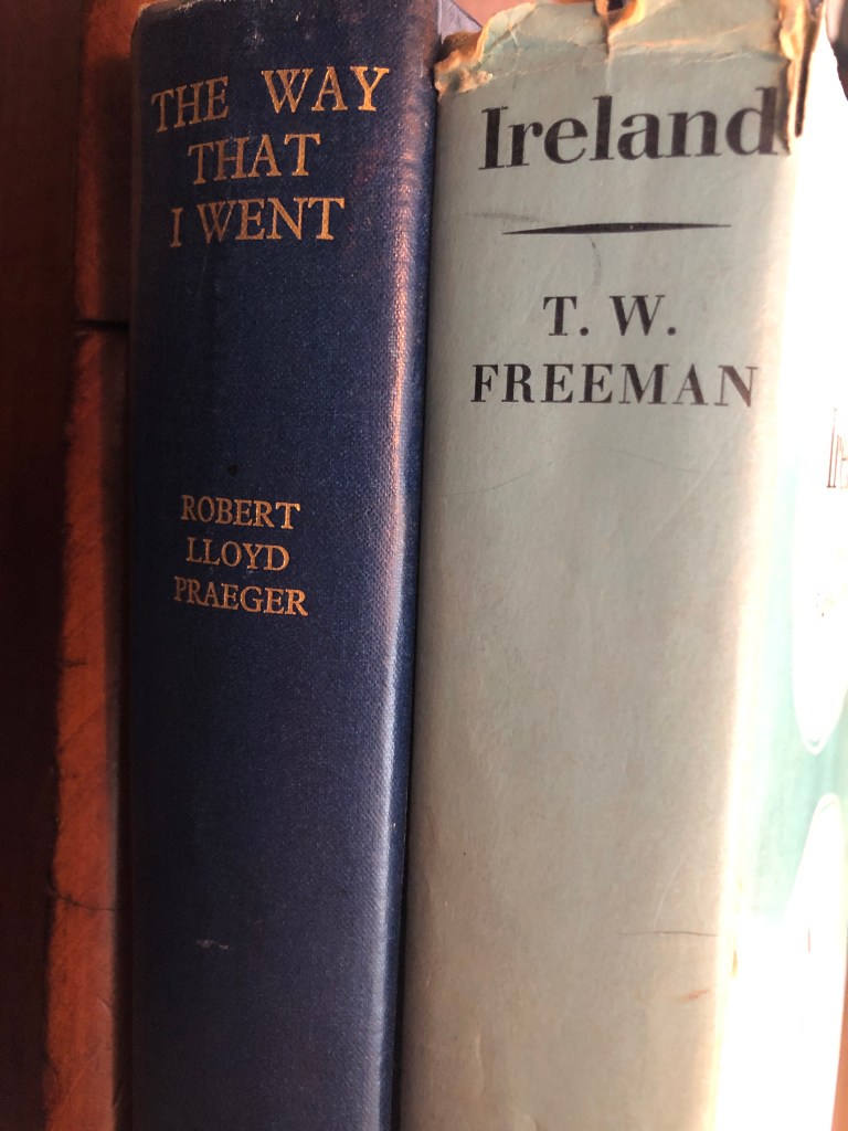
Frank Mitchell (1912–97) was a distinguished but unassuming academic, environmental historian, archaeologist and geologist. While he had many academic writings his best known book was The Irish Landscape (1976) about which he was typically modest. In 1990 Mitchell published ‘a semi-autobiography’ The way that I followed. The title was a play on Robert Lloyd Praeger’s, The way that I went (Dublin, 1937). A delightful exercise in ‘topographical autobiography’. Praeger in his peregrinations was less kind to Laois and Offaly than Mitchell with Praeger’s observation that ‘neither county need detain us long’ (p. 235) and ‘there is not much of special interest’ (p. 237). Westmeath he found to be more hospitable than Offaly having less than half of the amount of bog in Offaly and more pasture. We may look at the Praeger account in another blog. Suffice to say that bogs were not flavour of the month with the visitors from the 1800s to the 1930s and who wrote up accounts of their tours. Mitchell did not follow that century old prescription.
Someone who Mitchell would have known (at TCD) and admired was T.W. Freeman. The latter’s Ireland a general and regional geography (1950, third edition, 1963) provided a useful account of the boglands east of the Shannon and the eskers of the Central Lowland with a brief disquisition on the market towns ‘that differ so strangely in their material prosperity’. Freeman was fascinated by the unexpected and haphazard nature of economic life in some of the towns – he seems to have had in mind Tullamore and Clara.
In any case let us go back to look at what Mitchell wrote of the terrain east of the Shannon as part of this Grand Canal series.
Was it chance and circumstances that led fourteen Offaly men to be present in early July 1863 on the fields, hills, and laneways of Gettysburg in what was, and still is to this day, the single most important battle in American history?
Chance: the absence of any cause of events that can be predicted, understood, or controlled
Circumstances: a condition, fact, or event accompanying, conditioning, or determining another
On reading any account of the single most pivotal battle in American History it quickly becomes obvious to even those with zero knowledge of battlefield tactics and military history that the main factors that decided the final outcome came about as a result of chance and circumstances, good and bad luck, decisions that only after the dust settled on the fields of Pennsylvania in early July 1863 were deemed correct and, fatally, one single decision made by a seemingly invincible General Robert E. Lee that doomed his Confederate Army to defeat and almost by accident won a victory for a Union Army commanded by a seemingly hesitant General George Meade. The margin of victory for the Union army, in the opinion of most military historians, was so tight that small and snap decisions were the deciding factor and not brilliant military tactics. It seems that in the late evening of the 3rd of July 1863 it was chance and circumstances that had played the most important role in the outcome of the battle.
Coming into Carton West, a small townland east of Tullamore that can be found in the Kilbride civil parish, this parish following the division of the original parish, is distinct from a second civil parish of the same name (Clara). The landscape in this area is mainly woodland, with a bedrock of dark Limestone, as in in the Ballyduff Quarries, this was used in the 19th century Tullamore buildings.
Ballycowan castle in view, about 1958.
This parish lies in the ancient O’Molloy territory of Fir Ceall or Men of the Churches or Men of the Woods. Here you will find many archaeological sites, which some have been destroyed or taken back by nature.
Carton West is in the Electoral Division of Silverbrook, in Civil Parish of Kilbride, in the Barony of Ballycowan, in the County of Offaly The Irish name for Carton West is An Cartrún Thiar meaning the West Carton (land Measure). This is an old measure of land.
There is an open invitation to all those interested in the River Brosna to come to the book launch on Friday 22 March at 7.30pm in The Star (GAA hall) River Street, Clara hosted by Clara Heritage Society.
John Feehan has dedicated much of his life to studying and communicating the evolution of the landscape and how we have lived in and changed it – his previous Offaly publications have included books on the Slieve Blooms, Croghan Hill, the Landscape of Clonmacnoise, An Atlas of Birr and more recently Killaun Bog and the Camcor River. This new publication focuses on the River Brosna and its catchment.
The River Brosna is one of Ireland’s hidden rivers, glimpsed over bridges and for short stretches as it travels through Mullingar, Ballinagore, Kilbeggan, Clara, Ballycumber and Ferbane on its journey from Lough Owel to ShannonHarbour. Until now very little has been written about it yet few rivers have a more fascinating and varied story to tell. In this beautifully illustrated book John Feehan brings his long experience as an environmental scientist and historian to bear on all aspects of the natural, cultural and industrial heritage of the river and its catchment. Successive chapters review geological origins, the biodiversity of the river and its tributaries as well as the great area of bogland it drains. The history of the mills along the course of the river, and of the two great arterial schemes that so altered the river are reviewed and particular attention is devoted to the extraordinary stories of Mesolithic Lough Boora and the Bronze Age Dowris hoard.
As we make our way along we start to make the journey to Ballycommon, we come to Townparks townland, in the Electoral Division of Daingean, in Civil Parish of Killaderry, in the Barony of Lower Philipstown, in the County of Offaly. The Irish name for Townparks is Páirceanna an Bhaile. Townparks townland in Daingean has the site of Fort Governor which was built in 1547 on the site of an O’Connor Castle stronghold.
along this line we come to one of the gems along this way, the Bord Na Mona lifting Bridge, It’s an interesting spot and a great location to get the camera out. From the late 18th century, the canal was used as a way to transport turf from different cutting points along the line. As trading long the canal was increasing rapidly and was even more encouraged when charges were abandoned, the one that was always a difficult trade to control was the “Turf”[1].
03. The half-inch of c. 1910 from Philipstown to Ballycommon and Cappancur Offaly History Centre. Showing also the Kilbeggan Line of the 1830s.
A few incidents along the line was reported, before the construction of the Circular line, including situations where turf traders, held up and demanded change to the dispatching and the price of turf. After a standoff with an angry crowd, that were armed with swords and guns. The canal company, compromised with the people and ordered that all boats display a clear sign with the price of their turf.
During this time quays were used along the canal to unload turf and an inspector was appointed to see the overall control of the Turf trade. By the early 19th century, a steady flow of boats travelled up and down the line, with up to 33,000 tons every year arriving for dispatch. G- Boats were the main boat used when transporting product and with a fixed toll now applied to all traders, this encouraged the use of greater loads.
Michael Hoy was born in Daingean county Offaly in the year 1834 to William Hoy and Rosanna Concasey. His father died when he was a young boy. In 1853 he emigrated with his mother, brother William, and two sisters Rosanna and Elizabeth, settling in Brooklyn. His older brothers Joseph and John, along with another sister Mary had gone to America a few years before. Michael Hoy learned the stone cutters trade in Brooklyn. In 1854 the family moved to Cooperstown, New York, which is two hundred miles north of the city. Young Hoy worked in his trade for one more year before returning to Brooklyn. In 1857 he went to Minnesota, settling in the town of Saint Anthony. At this time Saint Anthony had a few scattered houses on the east bank of the Mississippi river. He followed his trade and the same year of his arrival he cut stone for the building of the State University.
Today with the canal being a popular walking destination, you can see along the canals places associated with the townlands . Just outside Rhode, on the way to Edenderry, are the ruins of old windmills of the eighteenth century. These once had a wind shaft mounted in the cap (one is preserved at the Guinness brewery and was used by the Roe distillery). The wind turned the millstones in the tower below and were used to help ground grains for flour.
Seven windmills are known to have been constructed during this period in Offaly. By 1830, most of the windmills had gone out of service. The last windmill to be used was dated up to 1880, called the Fahy Windmill[1]. Tullamore had two in the eighteenth century on the hill behind O’Moore Street.
Along our Grand Canal Journey from Edenderry to Shannon Harbour we come to Rogerstown, a small townland, in the Electoral Division of Monasteroris, in the Civil Parish of Monasteroris, in the Barony of Coolestown, in the County of Offaly.
The Irish name for Rogerstown is Baile Risteird meaning Richard’s/land.
(01.Monasteroris civil parish from the Index map Kings’ County 1838. Image source Offaly History Centre)
This article looks at the north Offaly towns featured in Major (later general) Vallancey’s report carried out in 1771 and designed to support the construction of the new Grand Canal line to Tullamore and the Shannon. Vallancey was then a young engineer, employed to report to the Commissioners of Inland Navigation and his findings were published in, AReport on the Grand Canal or Southern Line (Dublin 1771).[1] This report is useful as a window on some of the north King’s County (hereafter generally referred to as Offaly) towns and villages.[2]