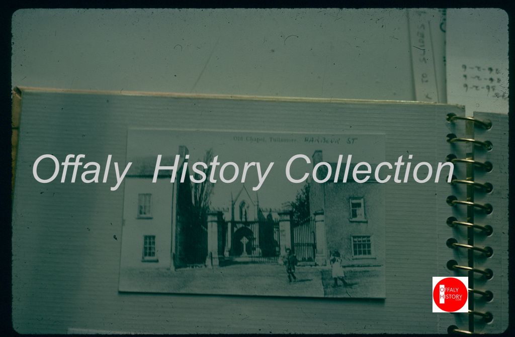
Towards the end of the 19th century the 1840 Mercy Convent with its frontage to the landscaped banks of the Grand Canal, was the most prominent symbol of the increasing importance of the Catholic Church in the spiritual life of the people of Tullamore. In contrast, the almost one hundred year old St Mary’s Parish Church, which had a capacity for 500 worshippers at most, was of a modest character. Located on a backland site behind Harbour Street on lands gifted by Lord Charleville it shared its cramped accommodation with the Parochial House.
The old church of 1802to 1903-4
As Michael Byrne records in his comprehensive historical survey of Tullamore Catholic Parish, the question of repairing the old church arose in 1897 but on the advice of the influential businessman and local politician Henry Egan, it was felt that building an entirely new church would be a better option.
No time was lost and on the 16th January 1898 a preliminary meeting of a Parish Council to plan for the new Church was assembled and six days later appointed the Cavan based architect William Hague whose brief was to provide a 1,600 seat structure with additional space for 500 more on special occasions.
Thursday May 19th 1938 was a big day in Tullamore. The occasion was the opening of 146 new houses on O’Molloy Street and the opening of a new outdoor Swimming Pool by the Tánaiste and Minister of Local Government and Public Health Mr. Sean T. O’Kelly. By Damien Byrne
The local newspapers of the day describe the town as being “profusely decorated with flags and bunting” with O’Molloy Street being “richly festooned with the Tricolour being strongly in evidence”.
The Tánaiste on his arrival at Tullamore, at 12:15 p.m., passed through a guard of honour of Civic Guards, drawn up outside Hayes Hotel. He was met at the door of the hotel by the members of the Council and public officials, and proceeded at once through Patrick St., Kilbride St., and Clara Bridge, where his arrival at O’Molloy Street was awaited by many clergy of all denominations and representatives of the laity. Along the route large numbers of people had gathered, and the Tánaiste smilingly bowed his acknowledgements of their greetings.
Kilgortin is in the Electoral Division of Rahan, in Civil Parish of Rahan, this parish is situated in the ancient O’Molloy territory of Fear Ceall meaning the mem of the woods or men of the churches. If you look closely along the line in this area you will see deposits of brick clays along the Grand Canal between Ballycowan and Rahan, this was the source of an energetic brick industry in the past. In this part of Rahan you will find the site of Rahan Monastic Centre, this is the most famous archaeological site in this location. It was a very important aspect of Early Christian period.
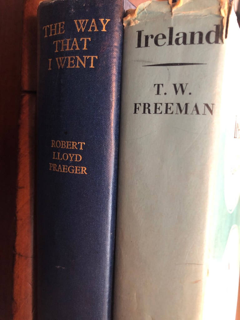
Frank Mitchell (1912–97) was a distinguished but unassuming academic, environmental historian, archaeologist and geologist. While he had many academic writings his best known book was The Irish Landscape (1976) about which he was typically modest. In 1990 Mitchell published ‘a semi-autobiography’ The way that I followed. The title was a play on Robert Lloyd Praeger’s, The way that I went (Dublin, 1937). A delightful exercise in ‘topographical autobiography’. Praeger in his peregrinations was less kind to Laois and Offaly than Mitchell with Praeger’s observation that ‘neither county need detain us long’ (p. 235) and ‘there is not much of special interest’ (p. 237). Westmeath he found to be more hospitable than Offaly having less than half of the amount of bog in Offaly and more pasture. We may look at the Praeger account in another blog. Suffice to say that bogs were not flavour of the month with the visitors from the 1800s to the 1930s and who wrote up accounts of their tours. Mitchell did not follow that century old prescription.
Someone who Mitchell would have known (at TCD) and admired was T.W. Freeman. The latter’s Ireland a general and regional geography (1950, third edition, 1963) provided a useful account of the boglands east of the Shannon and the eskers of the Central Lowland with a brief disquisition on the market towns ‘that differ so strangely in their material prosperity’. Freeman was fascinated by the unexpected and haphazard nature of economic life in some of the towns – he seems to have had in mind Tullamore and Clara.
In any case let us go back to look at what Mitchell wrote of the terrain east of the Shannon as part of this Grand Canal series.
Was it chance and circumstances that led fourteen Offaly men to be present in early July 1863 on the fields, hills, and laneways of Gettysburg in what was, and still is to this day, the single most important battle in American history?
Chance: the absence of any cause of events that can be predicted, understood, or controlled
Circumstances: a condition, fact, or event accompanying, conditioning, or determining another
On reading any account of the single most pivotal battle in American History it quickly becomes obvious to even those with zero knowledge of battlefield tactics and military history that the main factors that decided the final outcome came about as a result of chance and circumstances, good and bad luck, decisions that only after the dust settled on the fields of Pennsylvania in early July 1863 were deemed correct and, fatally, one single decision made by a seemingly invincible General Robert E. Lee that doomed his Confederate Army to defeat and almost by accident won a victory for a Union Army commanded by a seemingly hesitant General George Meade. The margin of victory for the Union army, in the opinion of most military historians, was so tight that small and snap decisions were the deciding factor and not brilliant military tactics. It seems that in the late evening of the 3rd of July 1863 it was chance and circumstances that had played the most important role in the outcome of the battle.
Coming into Carton West, a small townland east of Tullamore that can be found in the Kilbride civil parish, this parish following the division of the original parish, is distinct from a second civil parish of the same name (Clara). The landscape in this area is mainly woodland, with a bedrock of dark Limestone, as in in the Ballyduff Quarries, this was used in the 19th century Tullamore buildings.
Ballycowan castle in view, about 1958.
This parish lies in the ancient O’Molloy territory of Fir Ceall or Men of the Churches or Men of the Woods. Here you will find many archaeological sites, which some have been destroyed or taken back by nature.
Carton West is in the Electoral Division of Silverbrook, in Civil Parish of Kilbride, in the Barony of Ballycowan, in the County of Offaly The Irish name for Carton West is An Cartrún Thiar meaning the West Carton (land Measure). This is an old measure of land.
The Grand Canal reached Daingean in 1797. The changing landscape along the route of the new canal from Edenderry at its survey in 1800. Sir Charles Coote describes Philipstown /Daingean in No. 33 in the Grand Canal Offaly Series
The Grand Canal reached Daingean (Philipstown 1557-1920) in 1797 having been dug by upwards of 3,000 men from the access to the county at Cloncanon, Edenderry in about 1793. The next stage was making the line from Edenderry to Rhode, Toberdaly, Killeen bridge and into Daingean where the Molesworth bridge was built in 1796. After that it was on to Ballycommon, the 26th lock (Boland’s. ‘the Round House’) and the drop down all the time to Tullamore which was reached in 1798. The fall over the eight locks, from no 21 to no 28 at Clara bridge, Tullamore was about 73 ft. It was five years before the connection from the main line of canal at Cloncanon and Drumcooly was completed to Edenderry in 1802.
Coote in the survey published in 1801, dedicated to none other than General Vallancey who had surveyed the proposed line of the Grand Canal as far back as 1770 (see an earlier blog), was able to describe the scene close to the line of new canal of which so much was expected.
Tullamore is the county town of Co Offaly, it lies on the Grand Canal. It is a large and thriving place that has seen great development over the years. In this article, have a look back with a picturesque timeline through from 1798 when the canal reached Tullamore. We will return to Tullamore stories of the canal when the east west tour is completed.
Kilbride Parish: Seven Miles from East to West. The Parish lies in the ancient O’Molloy territory of Fir Ceall, or Men of the Church. It contains main archaeological sites some of which have sadly been destroyed or taken back by nature.
Tullamore is in the Electoral Division of Tullamore Urban, in Civil Parish of Kilbride, in the Barony ofBallycowan, in the County of Offaly. The Irish name for Tullamore is Tulach Mhór meaning Great Hill. The rising ground in Tullamore leads to the hill at High Street – Cormac Street.
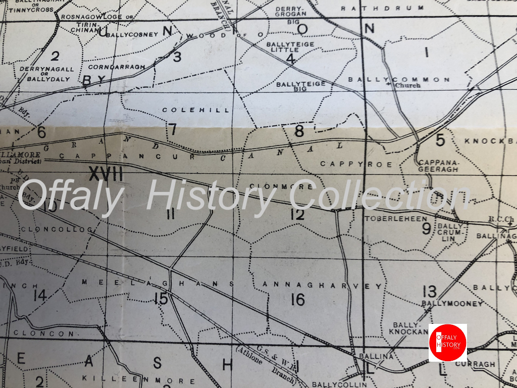
The Civil Parish of Geashill is the largest Parish in Offaly, and contains 74 townlands. As well as fine fields and bog land – dark, shale and lime mudstone, are just some of the materials you will find in its bedrocks.
The Parish is part of the ancient territory of “Ui Failghe of the O’Connor chiefs”. It contains some of the oldest remains of castles and is rich in history. From ancient sites such as Enclosures and Ringforts. Sadly many of them have been lost due to nature elements and neglect. It contains the town land of Cappyroe which borders the Grand Canal line, it is the 293rd largest townland in Co. Offaly and in Irish is Ceapach Aodha Rua, translation meaning Plot of Land[2].
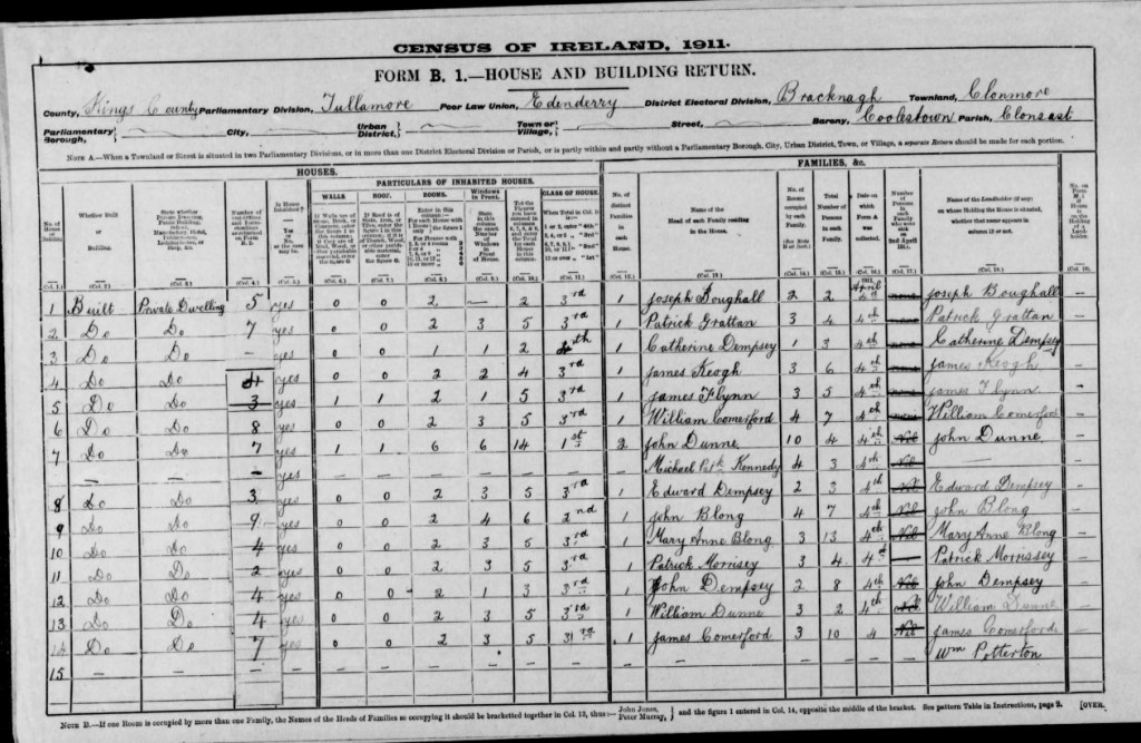
Map of the townlands from Ballycommon to Tullamore. There are over 1,000 townlands in Offaly. See townlands.ie for more.Your walk along the canal from Ballycommon will see you visit Cappyroe, Clonmore and Cappancur
In 1911 Cappyroe had one of the lowest concentration of houses in the area, during this period the household returns and ancillary, shows us that the population decreased from 106 in 1841 to 21 in 1911. There were 6 houses on record, all of all of Private Dwelling, with all inhabited, with classes of houses between 1st and 2nd . Age of occupiers ranging from 1-80. Here are the families that occupied these buildings during this time:
As we make our way along the line, we come to lock 22nd, which was previously mentioned in the last series of “East to West”. The 23rd Lock is followed close behind. A smooth and clear pathway can be found, making it easy to walk or cycle along the way. Coming up we see the 24th Lock. This lock is located near the former Celtic Canal Cruisers. We are preparing an article on this canal attraction, 1974-2004.
(08. Celtic Canal Cruisers / Image Source/ Offaly History). We are preparing a blog on this important cruise line. Can you help with material?
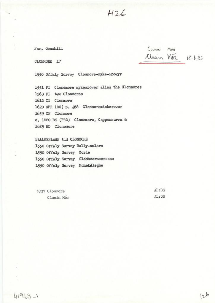
Clonmore (Cappancur), in the Civil Parish of Geashill, in the Barony of Geashill, in the County of Offaly. The Irish name for Clonmore is Cluain Mór meaning Great Field.
Clonmore is the site of a few known churches the Balleenlawn Church that stood until the early 19th century. Its Foundation, was discovered in 1942. It also contained an old graveyard that is still intact today[3].
In 1911 Clonmore had 26 houses in the area, during this period the household returns and ancillary, shows us that the population decreased from 220 in 1841 to 101 in 1911. There was 26 houses show on record all of all of Private Dwelling, with all inhabited, with classes of houses between 1st, 2nd and 3rd. Age ranging from 1-80. Here are some of the families that occupied these buildings during this time:
(15.Coachman, source Travel and Transport in Ireland, Edited by Kevin B.Nowlan)
With the construction of the Grand Canal it provided a better connection to reach different townlands around the country. With many place still not connected by waterway, the coach services provided that connect for passengers to reach their final destinations.
As we make our way out of the Geashill Civil Parish, we reach the 25th Lock and Just at Digby Bridge, here we can see just the spire of Tullamore’s Catholic church. Close by is the 26th lock, the barony bridge with its passage under the canal and on to Tullamore. More on Wednesday.
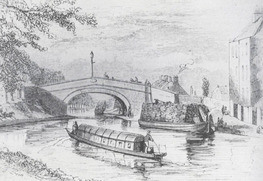
Flyboats on the canal in the 1830s, similar to the later design of the Celtic Cruisers fleet of the 1970s
[1] See “Safe Harbour, The Grand Canal at Edenderry” Mairead Evans & Therese Abbott” Topic Newsppapers Ltd, P22-23
[2] Offaly thought Time & Its Townlands. Thomas Lee. Pub: Ottait Publishing p173
[3] Offaly thought Time & Its Townlands. Thomas Lee. Pub: Ottait Publishing p173
There is an open invitation to all those interested in the River Brosna to come to the book launch on Friday 22 March at 7.30pm in The Star (GAA hall) River Street, Clara hosted by Clara Heritage Society.
John Feehan has dedicated much of his life to studying and communicating the evolution of the landscape and how we have lived in and changed it – his previous Offaly publications have included books on the Slieve Blooms, Croghan Hill, the Landscape of Clonmacnoise, An Atlas of Birr and more recently Killaun Bog and the Camcor River. This new publication focuses on the River Brosna and its catchment.
The River Brosna is one of Ireland’s hidden rivers, glimpsed over bridges and for short stretches as it travels through Mullingar, Ballinagore, Kilbeggan, Clara, Ballycumber and Ferbane on its journey from Lough Owel to ShannonHarbour. Until now very little has been written about it yet few rivers have a more fascinating and varied story to tell. In this beautifully illustrated book John Feehan brings his long experience as an environmental scientist and historian to bear on all aspects of the natural, cultural and industrial heritage of the river and its catchment. Successive chapters review geological origins, the biodiversity of the river and its tributaries as well as the great area of bogland it drains. The history of the mills along the course of the river, and of the two great arterial schemes that so altered the river are reviewed and particular attention is devoted to the extraordinary stories of Mesolithic Lough Boora and the Bronze Age Dowris hoard.