In the last blog we noted that the August 1923 General Election in Laois-Offaly was remarkably peaceful given that the civil war had only ended in May. Offaly was still strong in support for the Republicans as was clear from the fact they gained two seats, but, of course, were committed to not entering the Dáil. Labour’s William Davin continued to have a strong vote but not nearly so much as in June 1922. Tullamore’ Patrick Egan gained a seat on Labour transfers. Egan polled only 9 per cent of the first preferences.[1] In Laois-Offaly the Republicans outpolled Cumann na nGaedheal, but the latter won the by-election of 1926 created by the disqualification of Republican John or Séan McGuinness.[2] Overall Cumann na nGaedheal secured 38.9 per cent of the 1923 vote as to anti-Treaty Sinn Féin’s 27.4 per cent.[3] The Sinn Féin vote was secured in difficult circumstances with many still in prison or in hiding. As Joe Lee recorded the outcome was a resounding success for anti-Treaty Sinn Féin and a loss for Labour. Cumann na nGaedheal secured 63 seats, but that was a gain of only five in a Dáil enlarged from 128 to 153 seats. This was the election in which the franchise was extended to all women over the age of 21, thereby expanding the electorate from 1.37 million in 1918 to 1.72 million in 1923.
There was an extraordinary Synod held in Birr in 697AD. This synod was called by Adomnán, abbot of Iona, who arrived in Birr with the princes of church and state and who produced an edict that fundamentally challenged the way warfare was carried out in Ireland and beyond.
St Catherine’s Church, 1815. This is the second article to mark the successful Heritage Week 2023. The new St Catherine’s Church was designed by Francis Johnston and was built in the Gothic style with a Latin cross plan, side-aisles, a tower in the west and a crypt at the east end for the burial place of the Bury family. Its situation on Hophill makes it an impressive landmark in Tullamore. Hophill is a glacial mound which rises steeply to a height of about fifty feet above the land around it. It is not clear how the mound acquired its name or when. The earliest known reference to the hill occurs in a lease of 1748. There is a local story that the spoil for digging out the new lake at Charleville was used to construct the site for the new church. While this is not true perhaps some materials were used which gave credence to this story. Originally more pointed, the hill is a natural one.
The news that the Laois-Offaly constituency is to come to an end at the next general election, following the recommendations of the Electoral Commission, is an occasion to reflect on its long history.
Under the Government of Ireland Act of 1920, the constituency was established as King’s County-Queen’s County, a four-member constituency for the House of Commons of Southern Ireland, as it was then known to the British authorities.
It was first used in the 1921 election for the second Dáil. [ There was no actual polling as all 128 candidates were returned unopposed.] At various stages the constituency name was spelt as Leix-Offaly, Laoighis-Offaly until Laois-Offaly became official.
Laois Offaly is again to be divided into two three-seat constituencies according to the just announced electoral commission report. ‘This would be the first time that the Offaly constituency would fully align with its county boundary.’ For the 2016 General Election Laois and Offaly were divided and to the Offaly constituency was added 24 electoral divisions from North Tipperary. Laois-Offaly was adopted again for the 2020 general election. Now what was it like in the first Free State election in 1923 just 100 years ago? It was remarkable that the 1923 general election held on Monday 27 August 1923 was in general peaceful. It was only in early July 1923 that Ministers Milroy and Blythe spoke at a Cumann na nGaedheal (CnG) meeting in Tullamore in what was described by the Chronicle as scenes of an unprecedented character in the history of public meetings in Tullamore. The ‘supporters of Mr de Valera’ had posted anti-government posters about the town recalling the executions of Byrne and Geraghty, and also the three young men shot in Birr on a charge of armed robbery. On the office of the state solicitor, James Rogers, in High Street, Tullamore was pasted the words ‘Come inside and see the executioners’. Rogers would have been known both sides in the civil war as someone who defended Sinn Féin prisoners in the 1917–21 period. The newly appointed civic guards kept the peace between Cumann na Gaedheal supporters and supporters of the Republican IRA.[1]
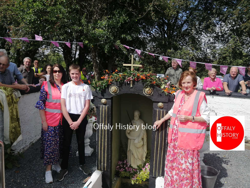
Bracknagh Heritage Society unveiled a statue of Saint Brochan in Saint Brochan’s Well, Clonsast, County Offaly for National Heritage Week. The Blessing was performed by Fr. Gregory Corcoran, P.P and by Reverend Alan Melbourne. Mary Briody on behalf of Bracknagh Heritage Society welcomed a large crowd who gathered at the Holy Well and Monastic site at Clonsast (on farmland) as Frances Cunningham unveiled the statue. Mary Delaney gave a talk on the History of St. Brochan and the 7th century monastic site. Pat Carey read an “Ode to St.Brochan’s Well”, composed by Mary Crotty.
The event was accompanied by the local Choir and Ciaran Flood played the pipes.
Address from Mary Delaney, local historian and chairperson of Bracknagh Heritage Society
Good afternoon, Fr. Corcoran, Reverend Melbourne, Ladies and Gentlemen
Today we gather in this sacred place to remember Saint Broghan and to pay tribute to him by placing a statue of the Saint into this holy well. We hope that this will enhance the historical importance of the monastic ruins here in Clonshannon and will provide a valuable resource for future generations.
From the early 6th century young men and indeed some young women, as was the case of Saint Brigid, left their homes and families and decided to devote their lives to God in a special way. Some joined monasteries and convents while others like Saint Broghan established their own monasteries. Today, only fragments of the landscape they created survive. Nonetheless they left a legacy that deserves recognition. This legacy is an important part of our historical past.
The townland of Clonsast or Clúin Sasta is the site of the monastery founded by Saint Broghan in the 7th century. Monks usually chose isolated locations on which to establish their holy grounds, locations that would be free from distraction. Clonsast translates as “the meadow of tranquility” and would have provided an idyllic refuge in which Saint Broghan and his monks could pray and work. The monastery was built on a section of dry land surrounded by the Bog of Clonsast and the greater Bog of Allen and was in close proximity to Croghan Hill, another important seat of worship.
Neville’s Atlas of the 3,000-acre estate at Philipstown in 1786 has not before been seen by the public and has probably not been consulted for fifty years. The surveyor was Arthur Richards Neville who was Dublin City Surveyor, 1801-1828 and he prepared the map on the instructions of the Molesworth Estate, the owner of 3,000 acres including the town of Daingean. Neville was in practice as a land surveyor from the 1780s or earlier. He succeeded RICHARD BURLEIGH WORTHINGTON as City Surveyor in 1801. He retained the post until his death in 1828 when he was succeeded by his son ARTHUR NEVILLE(Dictionary of Irish Architects online). The map is 154×128 cm and is 20 perch to the inch, taking in almost 3,000 statute acres and 130 land holdings. The map was conserved with the support of a grant from the Heritage Council. The map was donated to Offaly Archives in 2022. Our thanks to Arnold Horner for his assistance.
To mark Heritage Week 2023 we have two articles on St Catherine’s Church, Hop Hill, Tullamore. This week the background from the 1700s to the completion of the new church in 1815. When coming to Tullamore by boat or rail the two most prominent sites to greet the visitor are the spire of the Catholic church completed in 1906 and that of St Catherine’s church, built on the mound known as Hop Hill and completed in August 1815.
We take the presence of the Cof I churches of St Catherine’s, Clara, Shinrone, Geashill, Edenderry and St Brendan’s in Birr (to name a few) for granted. The upkeep is great and the contributors few.More will need to be done to structure support for the upkeep of these buildings.
A Francis Johnston plan with the burial crypt of c. 1808-10. Courtesy of the Irish Architectural Archive
Hop Hill site a brave choice
The Hop Hill site was a brave choice as there was work to be done to make it suitable for building and the adjoining ground was soft and prone to flood, especially in the years before the two Brosna drainage schemes of 1850 and 1950. The Tullamore town landlord, Charles William Bury (1764-1835), had reserved the large distillery plot (now the Granary apartments in Market Square) for a church, from about 1800 to 1806. In the latter year then rector, Ponsonby Gouldsbury, and the vestry opted for the Hop Hill site and the new church was largely completed in August 1815. Soon after the old church off Church Street, erected in 1726, was demolished and the site of the church and, possibly an adjoining graveyard, were used for the Shambles or meat market and the remaining land incorporated into the new Market Square or Corn Market. The new Bachelors Walk was worked on from about 1812 as an attractive avenue to the new church from the High Street and from the town’s owner’s new residence, Charleville Castle. The architect for the church was Francis Johnston and for the new avenue, or Bachelors Walk was John Claudius Loudon, the distinguished landscape architect and designer of demesnes.
The young Charles William Bury when aged 28 and just seven years into his estate. He married in 1798 and died in 1835. His best years were up to the completion of the castle. He contributed about £4,000 of the £8,000 it cost to build St Catherine’s.(more…)
The Tullamore and County Offaly Agricultural Show may be described as a unique cross urban/rural community undertaking and a traditional family day out attracting up to 60,000 people to the show. The Tullamore show was rekindled in 1991 by a small group of local people representing urban and rural communities. The Tullamore and Co. Offaly Agricultural Show Society Ltd was founded in 1990 and since its inception the Tullamore Show has grown to become one of Ireland’s largest and finest one day shows with entries from the 32 counties. In the early years of the 1990s the Tullamore Show was held in the grounds of Charleville demesne and castle in the month of August.
A 2018 show launch courtesy of the Show Gallery(more…)
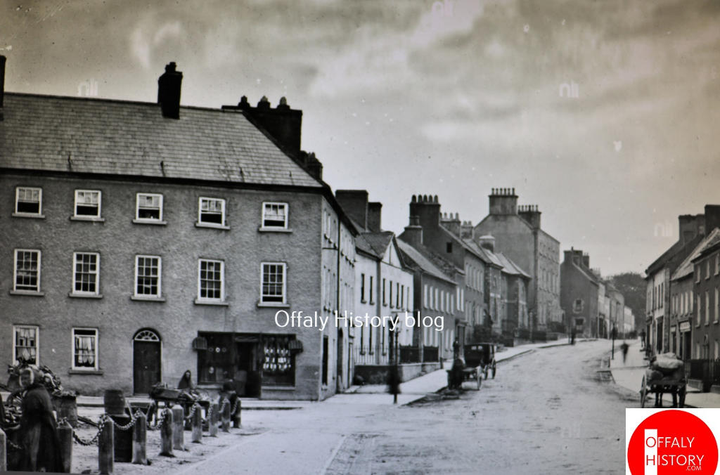
If walls could talk and archives survived, what would we learn about GV no. 48 High Street, Tullamore. A lot over its 275-year history so far. The number in the first printed valuation map of 1854 was no. 48. It is convenient to use this as the street was built by 1820, except for the Presbyterian church of 1865.
O’Connor Square and High Street were the principal streets in Tullamore from the 1740s to the 1960s. Charles Moore, the second Lord Tullamore, and from 1757 to his death in 1764 earl of Charleville, gave leases for substantial houses in High Street and these included the former Motor Works, the Round House, Mr Price building and Colonel Crow’s (no GV 48).
Most of the surviving houses in High Street date from the 1740s to the first fifteen years of the 1800s. Yet there is evidence of the commencement of a street here from 1713 with the building of houses GV 1, 2 and 3, followed in the 1740s and 1750s by GV 4, (O’Connor Square west for our purposes, from Bridge Centre entrance to the G.N. Walshe shop) and GV 5 and 6 High Street (Conway and Kearney and Guy Clothing). Both the northern and southern ends of High Street face important open spaces: the northern end forms the west side of O’Connor Square, and the southern end broadens out to form a triangular open space at the junction of O’Moore Street and Cormac Street.
High Street has been known by its present name since the early 1700s. However, until the early-nineteenth century High Street also included what is now Bridge Street. The street is uniformly wide throughout even allowing for the fact that some of the houses had railed-in areas to the front. Most of these, but not all, were destroyed by the 1970s.
This photograph of O’Connor Square and High Street was taken about 1900, or a little earlier (and preserved courtesy of the National Library) and shows the fine corner building erected by the distiller Joseph Flanagan in 1787 with its original glazing bar/windows and Georgian doorcases. This is the large building from the former Willie and Mary Dunne’s shop (GV 49) to the William Hill bookmaker’s office, beside Gray Cunniffe Insurance. Like the Adams-Tullamore House at the junction of O’Moore Street and Cormac Street it is a substantial three-storey house closing off the square on the southern side with some ten bays to O’Connor Square and six to High Street. The building was carefully planned as can be seen from this lovely old photograph, courtesy of the National Library of Ireland. This is the earliest surviving view of the building. South of it is no. 48 (with carriage outside).
Col. Crow’s is a fine three-storey, seven-bay house with a Gibbsian door-case and open-bed pediment. The building, for many years known as Colton’s Hotel, has now two shopfronts and the original railings and low wall fronting the basement were removed in the mid-1970s.The building has lost its original glazing bars. From the early Lawrence photograph of c. 1900 we can see that a third storey was added soon after the existing hotel was purchased by Abraham Colton. It was then that a pediment to the roofline was removed and the third floor added. It was not so unusual to add a floor and there are examples of it in Columcille Street with Galvin’s and Dolan’s.
This house was built in 1750 for Colonel Thomas Crowe and survived intact until about 1974. Part of the large garden was used in the building of the Rose Lawn housing scheme in the late 1980s. The house to the south was demolished in 1940 to make way for the new Ritz Cinema, opened in 1946 and demolished in 1980. Roselawn of 21 houses was completed about 1990.