Church Street is unusual in Tullamore in that it does not have a common width throughout and its lower half, closest to the town centre, is clearly earlier than the upper half from the Methodist church to the Pound Bridge over Tullamore River. While the building pattern is now post 1786 in date it did have at least two earlier buildings in the Protestant church built by Mrs Ellen Moore in 1726. She was the mother of the first Lord Tullamore who died in 1725. Charles the second Lord Tullamore succeeded while still a minor, having been born in 1712.[1] In an earlier article we reproduced maps from the 1770s depicting the church and noted that the building was shown on the on the 1730 Mountrath (Coote) estate map. The church stood in what was post 1820 the yard shown as The Shambles and was not aligned to the later street.[2]
(more…)Category: Quarrying/ stone
-
Local Heritage and Family History Course: Sources and Methods, 24 September to 26 November 2025 (ten sessions of two hours each) at Offaly History Centre, Bury Quay, Tullamore. Blog No 747, 13th Sept 2025
What? The course will give an overview of the sources and methods for the study of the archaeology, community and family history of County Offaly, and how to do research on areas that may interest you in local and family history. Thematic sessions will be delivered by experienced local scholars, who will introduce participants both to physical sources and to online resources. Offaly is taken as the example, but most of the records will have application for the entire country.
When? All talks will be held on Wednesday nights, from 7.30 to 9.30 pm.
Where? Offaly History Centre, Bury Quay, Tullamore, Co. Offaly, R35 Y5V0

Fees? The course fee for all ten sessions is €50, payable to the Offaly Heritage Centre at the time of booking. Please provide your credit or debit card details when booking, or visit the shop Monday–Friday, 9:30 am–4:30 pm.
Alternatively, payment can be made by bank transfer: Best contact us first as only a few places are left.
This course is supported by the Heritage Council and Offaly County Council.
Places are limited to 25 participants, so early booking is strongly advised.Please call or email us to check availability and make your booking
(more…)
-
Kilcruttin’s Forgotten People. Recapturing memories of Tullamore in the Sixties by Terry Adams. Blog No 676, 3rd Dec 2024
One of the essays in the new book on Tullamore in the Sixties to be launched on Friday 6 December 2024 at 7.30 p.m. at Offaly History Centre (beside the new Aldi store in Tullamore, all welcome) is that by Terry Adams on his beloved Cormac Street, Tullamore where his family have been located for 150 years or thereabouts. Terry’s is an evocative piece and one of 29 essays in this new book on Tullamore with over 300 pictures.
I stood with my back to Lloyd’s field, surrounded by memories of childhood and family. On my left, back towards the town, my Grandmother Egan’s family home, The Hall, now the municipal council offices, nestles behind its railings and garden. Opposite, on the junction of Cormac Street and O’Moore Street, stands the building I was born in, now home to my brother Brian. My Adams grandparents’ house faces me across the street. Further along the imposing old courthouse and jail buildings sit in their solemn majesty.
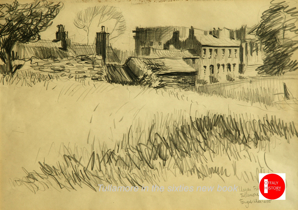
The view from Kilcruttin Hill courtesy of Fergal MacCabe Cormac Street, my street, even if I have not lived here since 1981. When I think of home it is to this street, to these buildings, my mind roams. It is a major part of me, of my identity, of who I am, of who I always will be. I look back towards the town centre, the street has changed little since my childhood. The house exteriors, excluding The Hall, have not been radically altered but most of their old occupants have left us: my father, also Terry, Frank and Carmel Egan, Ray and Sylvia Courtney, Ray and Emer McCann, Mr and Mrs McNeill, Mr and Mrs Brennan, Bridie Byrne, Jimmy and Marcella Byrne, Mrs Behan, Paddy and Mrs. Lloyd……
(more…)
-
19 The Grand Canal in Offaly and Westmeath: the five great aqueducts: Part Two. By James Scully. No 19 in the Grand Canal Offaly series. Blog no 574, 10th Feb 2024

Part two of this presentation looks at the Charleville and Macartney aqueducts west of Tullamore and the Silver River aqueduct halfway between Ballycommon and Kilbeggan.
- THE CHARLEVILLE AQUEDUCT
The Clodiagh River rises in Knockachoora Mountain in Sliabh Bloom and flows swiftly through Clonaslee and on under Gorteen, Clonad and Mucklagh bridges into Charleville Demesne before passing under the Charleville Aqueduct, just before its confluence with the Tullamore River at Kilgortin in Rahan. Less than half a mile upstream on the canal stands the Huband Aqueduct overlooked by the imposing Ballycowan Castle.
The Charleville Aqueduct is called after Charles William Bury who had become Viscount Charleville in December 1800 and it was as such, he was recorded in the lists of attendees of the Court of Directors of the Grand Canal Company during the years the canal was being constructed from Tullamore to Shannon Harbour, 1801-04.

Image 1. excerpt from the minutes
An excerpt from the minutes of a meeting of the canal company held 24th February 1801 where Lord Charleville’s request for the use of one of the company’s boats for the purpose of conveying Lady Charleville to town was accommodated. The memo further states that his wife was in a precarious state of health, most likely an allusion to her being in the advanced stages of pregnancy as her son Charles William Bury was born nine weeks later, on 29th April 1801. (Courtesy of National Archives of Ireland, Dublin)

Image 2. Charles William Bury, 2nd earl
Charles William Bury, 2nd Earl of Charleville, born late April 1801, seated in red cloak before a curtain, portrait by Henry Pierce Bone, 1835.
C. J. Woods’s entry for the first earl of Charleville, (1764-1835), in Dictionary of Irish Biography, R. I. A., (2009), gives a concise résumé of his adult life:
Bury was MP for Kilmallock in 1789–90 and 1791–7, becoming Baron Tullamore on 26 November 1797, Viscount Charleville on 29 December 1800, and 1st earl of Charleville (of the second creation) on 16 February 1806. He was an Irish representative peer from 1801 until his death. With Johnston he designed and built a Gothic castle on his demesne, Charleville Forest, 3 km south-west of Tullamore. Begun by November 1800, it was completed in 1808, to which a terrace, lawns, artificial lake, grotto, and 1,500 acres of woodland were added. Elected a fellow of the Royal Society in 1803 and a fellow of the Society of Arts in 1814, Charleville had ‘wide intellectual interests which never came to fruition’. The earl of Charleville died 31 October 1835 in his lodgings at Dover and was buried at Charleville.
Fred Hammond’s great survey of the bridges in Offaly (2005) gives the following description of the building:
Triple-span masonry bridge carries Grand Canal over Clodiagh River. Abutments, piers and cutwaters are of dressed limestone blocks, regularly laid. The cutwaters are of triangular profile and rise to arch spring level at both ends of the piers. The arches are of segmental profile and each spans 3.07m; their voussoirs are of finely dressed stone. The soffits are very slightly dipped towards their centres to accommodate the bed of the canal. Dressed string course over arch crowns. Parapets are of random rubble, coped with dressed masonry blocks. The parapets are spaced at 10.08m and terminate in out-projecting dressed stone piers. The east end of the south parapet has been rebuilt. The canal narrows to 4.50m, with tow paths either side. The sides are stone lined at this point and there are timber stop slots at the east end of the aqueduct.
Hammond considered the edifice worthy of regional heritage importance.
THE MACARTNEY AQUEDUCT

Image 3. Detail of William Ashford’s painting
Detail of William Ashford’s painting of the crowded scenes at the opening of the Ringsend Docks, Dublin, 23 April 1796, showing Lord Camden, the Lord Lieutenant of Ireland, conferring a knighthood on Mr. John Macartney with the Westmoreland, Buckingham and Camden Locks in the background. Macartney can be seen in a genuflected position on the right-hand quay wall beneath a billowing British naval flag. (Courtesy of the National Gallery of Ireland)
This is the western-most aqueduct in Offaly straddling the townlands of Falsk and Derrycarney, south of Ferbane. The structure is named after Sir John Macartney, one of the more influential directors of the Grand Canal Company. As alluded to above he was knighted by the Lord Lieutenant at the opening of the Grand Canal Docks in 1796, “in consequence of his energetic exertions in the promotion of the inland navigation of Ireland.” Like Huband’s Aqueduct at Ballycowan, it has two commemorative plaques dating it to 1803.

Image 4. Commemorative plaque dated 1803
Commemorative plaque dated 1803 on the south parapet wall of the Macartney Aqueduct.
Fred Hammond’s appraisal of the building says it all:
This is the largest aqueduct on the Grand Canal in Co. Offaly and second only to the Leinster Aqueduct (Co. Kildare) in size on this canal. It is of high-quality construction and has been sympathetically refurbished. It is of historical interest due to attested date and link with Grand Canal Co. Also, a substantial landscape feature hereabouts. Of national heritage significance, meriting inclusion in Record of Protected Structures.
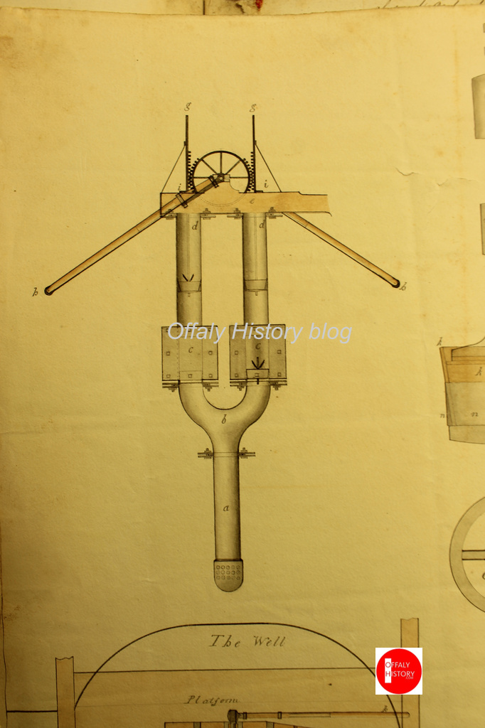
Image 5. A delightful drawing by Israel Rhodes
A delightful drawing by Israel Rhodes, dated to March 1802, showing details of the steam-powered pump that was used during the construction of the Macartney Aqueduct over the Silver River. This is from the minute books of the Grand Canal Company where such visual representations are very rare. The depiction is signed by Rhodes as engineer and by Arthur Chichester Macartney, then an influential director of the canal company. (Courtesy of National Archives of Ireland, Dublin)
The aqueduct crosses the fast-flowing Silver River after it has meandered over twenty-miles from the slopes of Wolftrap Mountain high up in Sliabh Bloom The river’s course takes it through Cadamstown, Ballyboy, Kilcormac and Lumcloon before joining with the Brosna half a mile downstream of the aqueduct.
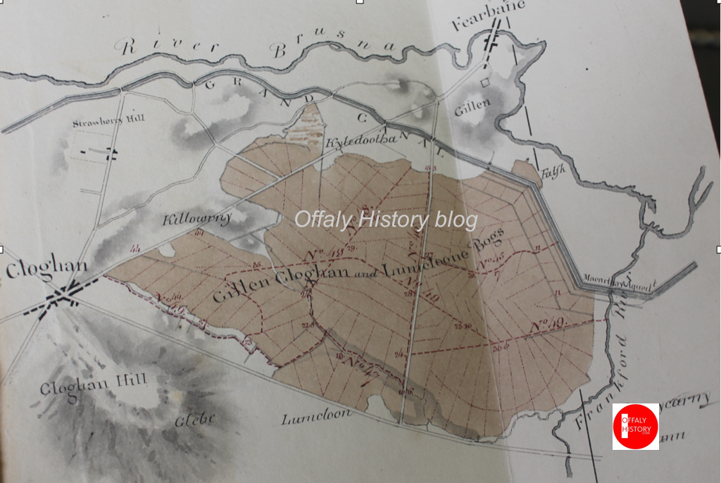
Image 6. Map by John Longfield c.1810
Map by John Longfield c.1810 showing the Grand Canal turning sharply to the north-west just downstream of the Macartney Aqueduct and thus avoiding the Gallen, Cloghan and Lumcloon complex of bogs before meandering (almost) from Gallen to Belmont, always in close proximity to the River Brosna. The Silver River is depicted as the Frankford River in deference to the old name for Kilcormac, the last town it passes through before its confluence with the Brosna. (Courtesy of The National Library of Ireland)
- SILVER RIVER AQUEDUCT ON THE KILBEGGAN BRANCH
To avoid confusion with the other Silver River crossed by the Macartney Aqueduct, this aqueduct straddles the Silver River which separates the counties of Offaly and Westmeath between the townlands of Bracklin Little and Lowertown. The river rises upstream of New Mill Bridge, in Rahugh, in Westmeath. In Offaly it flows via Derrygolan, Acantha, Gormagh, Ballyduff, Aharney, Coleraine, Coolnahely and Aghananagh before joining the Clodiagh at Aghadonagh, in Rahan. The 1838 six-inch map shows five mills on this relatively short river. The earliest of these mills is probably that at Ballynasrah or Tinnycross as it is shown on John Gwin’s map of the Barony of Ballycowan which was drawn c.1625, almost four hundred years ago.
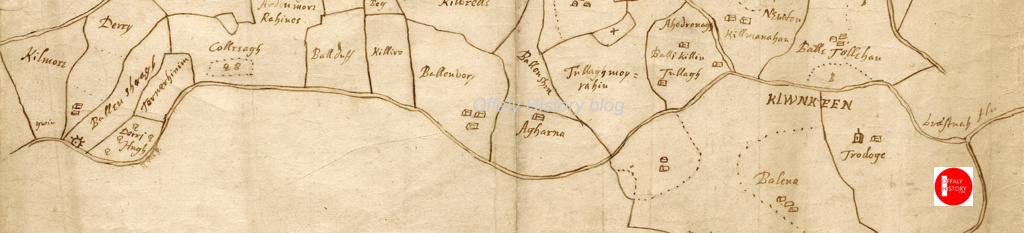
Image 7. Detail of John Gwin’s map showing Silver River
Detail of John Gwin’s map of the barony of Ballycowan which shows the Silver River flowing from Ballynasrah in the bottom left-hand corner to its confluence the Clodiagh at Aghadonagh on the right- hand side, passing Ballyduff, Aharney and Tullymorerahan. The mill is indicated by a mill-wheel symbol. The map is part of a set of twenty-eight important maps of various parts of Offaly drawn four hundred years ago in the Mathew De Renzy papers in the National Archives in London.
KILBEGGAN BRANCH
As early as 1806 the Grand Canal Company’s engineer John Killaly had prepared a detailed map for a proposed branch from Ballycommon on the main canal to Kilbeggan. This line was closely adhered to when work finally begun twenty-four years later in 1830. An application for funding was made in 1825 and despite strenuous objections from the Royal Canal Company a loan was approved in 1828. In March 1829 Killaly had completed the plans and specifications for the line. A month later William Dargan’s proposal to build the line for £12,850 was accepted.

Image 8 William Dargan
William Dargan, (1799-1867)
From the outset work was slow due to continuous wrangling between the contactor and the company. Dargan had taken his own levels, but the canal company insisted he use those of Killaly. Even when progress was made recurring problems with staunching the huge embankments at Bracklin Little and Lowertown delayed construction. Allied to this was the major distraction of Dargan’s involvement with the building of Ireland’s first railway line.

Image 9. Bracklin Little and Lowertown townlands on the 1912
Bracklin Little and Lowertown townlands on the 1912 Ordnance Survey six-inch map, showing the meandering Silver River and the dense hachuring between Lowertown and Murphy’s bridges. This represents the steep slopes of the embankments which carry the aqueduct high above the surrounding landscape. Note the overflow at south end of the aqueduct. This was to prevent the level of the canal rising to a height where it would overflow the banks and lead to a major breach. Just like at the Blundell Aqueduct there were twenty-six miles of canal without a lock which would have poured out at this point if a burst occurred, leading to much destruction and a long-term closure of the navigation.
Dargan’s chief biographer Fergus Mulligan describes this episode in Dargan’s life in the Royal Irish Academy’s Dictionary of Irish Biography:
Ireland’s first railway line, the Dublin & Kingstown, opened in 1834 and Dargan was fortunate to win the contract to build it against six competitors. Working under another Telford pupil, Charles Vignoles (qv), as engineer, Dargan began work near Salthill in April 1833, and although he was six months late finishing the line (which opened on 17 December 1834) the penalty clauses in his detailed contract were not enforced. The successful completion of this line gave Dargan a springboard to winning a substantial share of Irish railway construction contracts on offer in the 1840s and 1850s.
Again, we are greatly indebted to Fred Hammond’s monumental survey of all 407 bridges in Offaly in 2005 for a detailed description of this aqueduct:
A tall arched masonry bridge carries the disused Kilbeggan Branch of the Grand Canal over the Silver River at the county boundary. The abutments are of dressed limestone blocks, regularly laid and with finely dressed quoins. The arch is of semi-circular profile, with finely dressed radial voussoirs and dressed stone soffit blocks; it spans 3.59m. The arch is embellished with finely dressed string courses around the tops of the quoins and across the crown. Over the top of the upper string course are four regular courses of dressed stone blocks. They are surmounted by a slightly inset random rubble parapet. The sloping wing walls are detailed as the abutments and are coped with stone flags.
-
18 Guinness, Thomas Berry & Co and the carrying trade on the Grand Canal, Dublin to Tullamore and Shannon Harbour. No. 18 in the Grand Canal Offaly series. Michael Byrne. Blog No 573, 7th Feb 2024
Patrick Lynch and John Vaizey in their history of Guinness’s brewery in the Irish economy to 1876 observed that in England the canals followed trade while in Ireland it was hoped that trade would follow the canals. It was a hope that was only partially fulfilled as outside of Dublin the new canals served few areas of commercial or industrial importance.[1] The observation was following in the line of Arthur Young in the 1770s who had advised ‘to have something to carry before you seek the means of carriage’.[2] Yet the record of the carriage of goods on the canal was satisfactory with 500 million ton miles carried in 1800 and double that by the 1830s.[3] The Grand Canal was especially beneficial to north Offaly for the transport of stone, brick, turf, barley, malt and whiskey. All bulky goods suited to water transport. The emerging firm of Guinness also found the inland water transport system helpful to sales and market penetration. The slow movement of Guinness beer by waterway was good for product quality on arrival.

The view is about 1840 and the book 1960. There is a copy at Offaly History Centre Library Work on the Grand Canal started in 1756 and by 1779 the first stretch of water from James’s Street to Robertstown was completed. Over the next twenty years the canal was extended to Tullamore (1798) and Shannon Harbour (1804). The six-year delay at Tullamore while resolving issues with the direction of the ‘Brosna Line’ at Tullamore facilitated the establishment of a canal hotel, stores and a harbour.
(more…)
