A rambler to Geashill in 1936 recorded his thoughts on the railway station, the village itself and the poems of Edward Egan who lived close by at the Meelaghans. The railway station closed about 1961, and Edward Egan better known as ‘The Poet’ Egan was in his last years when Rambler visited in 1936. For all the praise for Egan there were few at his funeral in Killeigh old churchyard. Nor is there any tombstone to mark his name.
It is hard to believe that we are catching up on history. In seven years time we mark the 200th anniversary of the building of the Catholic church in Durrow. This year is the thirtieth anniversary of the major renovation. The catholic church now in use at Durrow dates back to 1831and was completed in 1832 and consecrated by the then bishop Rahan-born Dr John Cantwell, on 24 September 1832. In an unpublished report on the houses and churches of County Offaly prepared for the Offaly Historical Society in 1985, William Garner wrote:
From the ending of our most recent Ice Age to the arrival of our First Farmers, the Irish landscape changed little other than the reduction of our land space with rising sea waters from the melting ice cap. The Mesolithic peoples left minimal traces behind such as that at Lough Boora, Offaly.
The First Farmers introduced land clearances in order to sow crops, crops led to surpluses. Surpluses were used for sowing in the next year and also for trade. Crops led to settlement where people no longer needed to hunt or to gather in the same way. Settlement and farming also led to a substantial growth in the Irish population. Later, farm animals appear requiring further land clearances. DNA evidence is emerging that new groups of people were coming into Ireland, resulting in the previous hunter gatherer population disappearing from the landscape.
The organisation of farming resulted in changes to the diet while settlement in specific locations led to wealth and people living longer. We then start to see monuments appear on the landscape particularly for burials of members of the elite, almost always male. Many of the structures were built to honour the dead and their ancestors, some were richly furnished and provide more evidence of the wealth of those living in the Bronze Age.
In April 2023 our little history group had a successful trip to the town of Wexford, where it was decided that our next outing would be Tullamore. So, on 28 September, we came together for lunch in the bar of the Bridge House, of which I have fond memories of getting warm and dry after a trek in driving rain from Daingean during my walk across Ireland in 2001, before checking in to our bed and breakfast accommodation at the Sea Dew guesthouse.
After lunch we took a walk up the town to have a look at the Offaly History Centre owned by the Offaly Historical and Archaeological Society. It is a very impressive facility indeed, an extensive premises just chock-a-block with books old and new, collections of records of all kinds, bound newspapers, photographs, family papers, school records – the list goes on and on. Michael Byrne had been introduced to me by Fergal McCabe: Fergal’s watercolour works are everywhere there.
Frank Mitchell (1912–97) was a distinguished but unassuming academic, environmental historian, archaeologist and geologist. While he had many academic writings his best known book was The Irish Landscape (1976) about which he was typically modest. In 1990 Mitchell published ‘a semi-autobiography’ The way that I followed. The title was a play on Robert Lloyd Praeger’s, The way that I went (Dublin, 1937). Praeger in his peregrinations was less kind to Laois and Offaly than Mitchell with Praeger’s observation that neither county need detain us long (p. 235) and ‘there is not much of special interest’ (p. 237). Westmeath he found to be more hospitable than Offaly having less than half of the amount of bog in Offaly and more pasture. We may look at the Praeger account in another blog
There is an open invitation to all those interested in the River Brosna to come to the book launch on Friday 22 March at 7.30pm in The Star (GAA hall) River Street, Clara hosted by Clara Heritage Society.
John Feehan has dedicated much of his life to studying and communicating the evolution of the landscape and how we have lived in and changed it – his previous Offaly publications have included books on the Slieve Blooms, Croghan Hill, the Landscape of Clonmacnoise, An Atlas of Birr and more recently Killaun Bog and the Camcor River. This new publication focuses on the River Brosna and its catchment.
The River Brosna is one of Ireland’s hidden rivers, glimpsed over bridges and for short stretches as it travels through Mullingar, Ballinagore, Kilbeggan, Clara, Ballycumber and Ferbane on its journey from Lough Owel to ShannonHarbour. Until now very little has been written about it yet few rivers have a more fascinating and varied story to tell. In this beautifully illustrated book John Feehan brings his long experience as an environmental scientist and historian to bear on all aspects of the natural, cultural and industrial heritage of the river and its catchment. Successive chapters review geological origins, the biodiversity of the river and its tributaries as well as the great area of bogland it drains. The history of the mills along the course of the river, and of the two great arterial schemes that so altered the river are reviewed and particular attention is devoted to the extraordinary stories of Mesolithic Lough Boora and the Bronze Age Dowris hoard.
Along our Grand Canal Journey from Edenderry to Shannon Harbour we come to Rathmore, a small townlands, on the south side of the canal. Rathmore is in the Electoral Division of Edenderry Rural, in Civil Parish of Monasteroris, in the Barony of Coolestown, in the County of Offaly.
The Irish name for Rathmore is An Ráth Mór meaning great, big ring-fort.
Here we can find the site of a possible Enclosure, it can be seen in outline from aerial photos. Enclosures are one of the most common sites found in Co. Offaly, with over hundred found all over the county. They are often similar to other types of enclosures defined either by a bank or a fosse, such as the Ringforts.
They are identified from other enclosures by being either very large or small and without an entrance. Many are only known as cropmarks, visible only from aerial view, they have no original dates but some may be from the Iron Age.
There was an extraordinary Synod held in Birr in 697AD. This synod was called by Adomnán, abbot of Iona, who arrived in Birr with the princes of church and state and who produced an edict that fundamentally challenged the way warfare was carried out in Ireland and beyond.
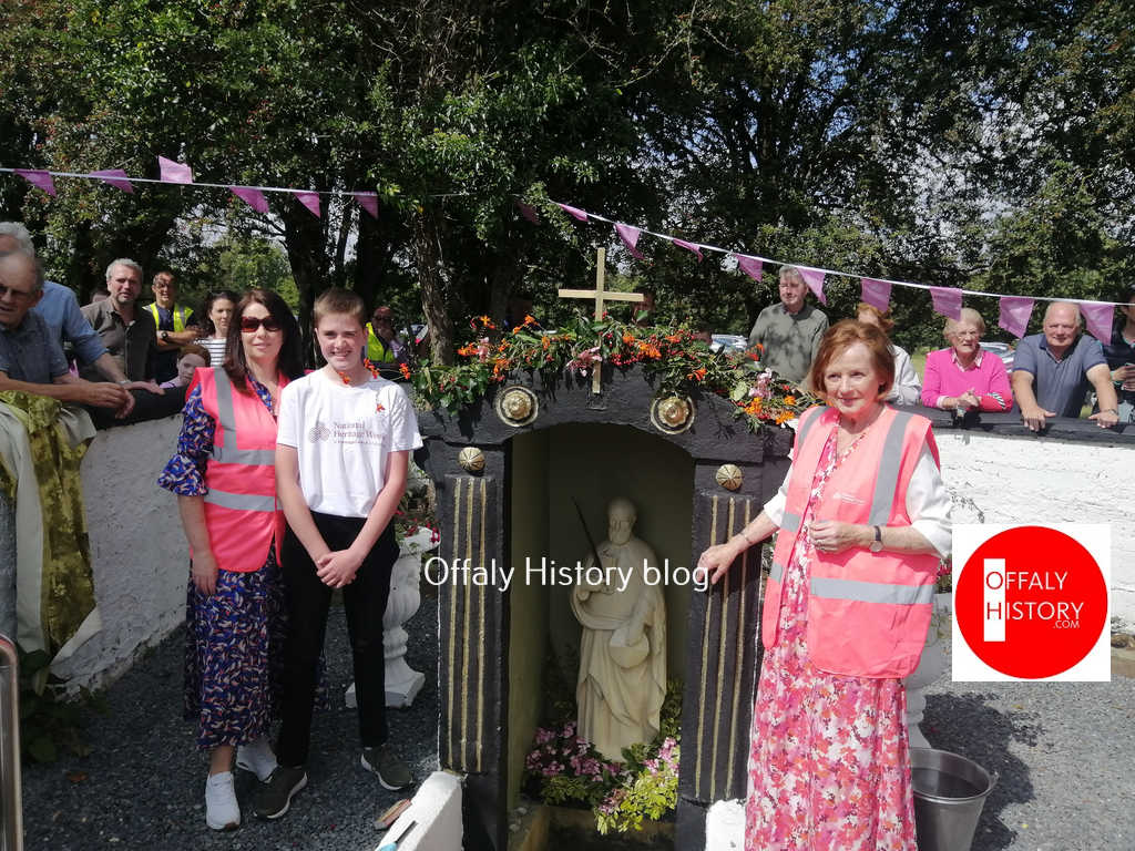
Bracknagh Heritage Society unveiled a statue of Saint Brochan in Saint Brochan’s Well, Clonsast, County Offaly for National Heritage Week. The Blessing was performed by Fr. Gregory Corcoran, P.P and by Reverend Alan Melbourne. Mary Briody on behalf of Bracknagh Heritage Society welcomed a large crowd who gathered at the Holy Well and Monastic site at Clonsast (on farmland) as Frances Cunningham unveiled the statue. Mary Delaney gave a talk on the History of St. Brochan and the 7th century monastic site. Pat Carey read an “Ode to St.Brochan’s Well”, composed by Mary Crotty.
The event was accompanied by the local Choir and Ciaran Flood played the pipes.
Address from Mary Delaney, local historian and chairperson of Bracknagh Heritage Society
Good afternoon, Fr. Corcoran, Reverend Melbourne, Ladies and Gentlemen
Today we gather in this sacred place to remember Saint Broghan and to pay tribute to him by placing a statue of the Saint into this holy well. We hope that this will enhance the historical importance of the monastic ruins here in Clonshannon and will provide a valuable resource for future generations.
From the early 6th century young men and indeed some young women, as was the case of Saint Brigid, left their homes and families and decided to devote their lives to God in a special way. Some joined monasteries and convents while others like Saint Broghan established their own monasteries. Today, only fragments of the landscape they created survive. Nonetheless they left a legacy that deserves recognition. This legacy is an important part of our historical past.
The townland of Clonsast or Clúin Sasta is the site of the monastery founded by Saint Broghan in the 7th century. Monks usually chose isolated locations on which to establish their holy grounds, locations that would be free from distraction. Clonsast translates as “the meadow of tranquility” and would have provided an idyllic refuge in which Saint Broghan and his monks could pray and work. The monastery was built on a section of dry land surrounded by the Bog of Clonsast and the greater Bog of Allen and was in close proximity to Croghan Hill, another important seat of worship.
Mag Léna is of interest for two events that occurred in the early historic period. The first event is the pseudo historic Battle of Mag Léna. The second event was the significant Synod of Mag Léna and the Letter of Cummain, part of the Irish church row with Rome over the dating of Easter.
Both incidents caused a split in Ireland!
What’s in a name?
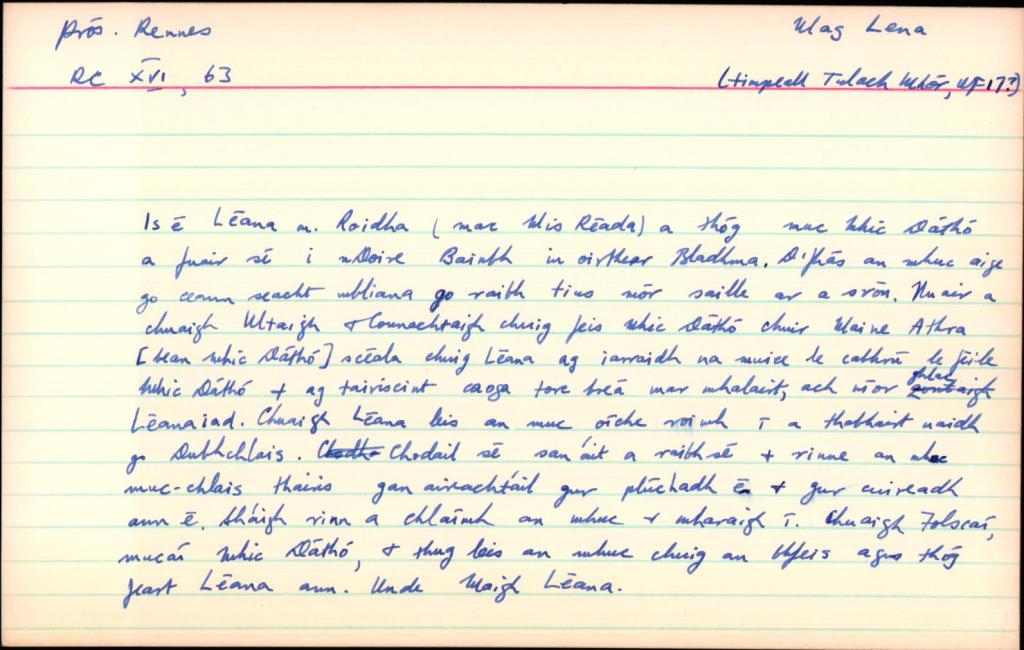
Mag Léna is mentioned in logainm.ie as Moylena and places it in the parish of Kilbride, Co. Offaly. Mag or Magh translates as a plain or open country, there is no information provided on the meaning of the word Léna. Unusually, there are no additional references other than the basic location details, also this older relic from the original card index system below. A 13th century manuscript mentions Cath Mhuighe Léana. Magh Léana is mentioned elsewhere. In his Survey Letters we find O’Donovan used a variety of spellings for the name – Moylena, Moyléna, Moyleana, Moleany and Moy-leana.
Logainm index card for Mag Léna.
As usual there are difficulties with the older Gaelic placenames and how they were recorded over time. Today the only memory of the name is in Tullamore, where the Moylena road joins the Clara Road and eventually joins the Rahan Road through Glendaniel.