There is little doubt that contact by sailors from Norway had occurred over many years in the 8th and 9th centuries between the islands of northern Scotland, the east coast of England and with Ireland. Most of these sailors would have been fishermen or traders and would have acquired details of the Irish coastline, location of rivers and awareness of monastic sites. This intelligence was readily available when the Viking raiders came calling.
Tony Lucas in his paper on the plundering of Irish churches makes the point that of the 309 ecclesiastical sites that were plundered between 600 and 1163AD, the Irish themselves were responsible for 139 of these. Only 140 of these can be directly attributed to the Vikings and 19 raids are attributed to the Irish and Norse together. An entry in the Annals of Ulster for 755 records ‘The burning of Cluain Moccu Nóis on the twelfth of the Kalends of April’ by the Irish long before the arrival of any Viking.
John O’Donovan was in Birr in early 1838 and having obtained a copy of The Picture (1826) by Thomas Lalor Cooke thought better of him as a scholar, but one subject to some foolish ideas after the school of Charles Vallancey. O’Donovan identified Cooke as ‘B’ in the Penny Journal articles he wrote and one of these was on the monastery of Seir Kieran at Clareen. It is interesting to compare the article in the 1834 issue of the DublinPenny Journal with that in the 1875 publication. Also of interest is to take into account the manuscript annotations to the Picture of 1826, now in Birr Castle Archives. And if that was not enough Cooke has letters and other MS sources in the RIA, NLI and the National Archives. In his letters of 1850 to the Cork antiquarian, John Windle (now in RIA) he tells Windle that he was the author under the pseudonym ‘B’ of articles in the Penny Journal and under his own initials of articles in the Dublin Evening Post. Despite the published work of George Petrie on the Round Towers (1833 and 1845) Cooke continued to put forward the Vallancey-style notion that the origin of the round towers lay in early times and were temples of fire.
The origin of Lynally as a religious centre can be traced to Colmán who founded a monastery here in the seventh century. His death is recorded in 611. Colmán himself was from Connor in modern day county Antrim. His family were of the Dál Sailni clan who ruled the area around Connor. According to an early Latin life of Colmán, it was St. Columcille who requested that a site be granted to Colmán for a monastery and as a result Aed Sláine (d.604) granted him Lynally.
Three ‘Lives’ of St. Colmán have come down to us, two in Latin and one in Irish. It should be pointed out that these so called ‘Lives’ are not biographies. Written long after the saint’s death the so called lives are in fact glorified fictional accounts of the saint’s life designed to justify property claims or political allegiances of his foundation by linking them to purported events in the founder’s life. Thus the close relationship between Lynally and St. Columcille’s foundation at Durrow is depicted in the lives by tales of friendly encounters between Colmán and Columcille. We have already seen how the early life of Colmán credits the founding donation of the site of Lynally to the request of Columcille while a later Irish Life even claims that Columcille’s sister was Colman’s aunt.
It is hard to believe that we are catching up on history. In seven years time we mark the 200th anniversary of the building of the Catholic church in Durrow. This year is the thirtieth anniversary of the major renovation. The catholic church now in use at Durrow dates back to 1831and was completed in 1832 and consecrated by the then bishop Rahan-born Dr John Cantwell, on 24 September 1832. In an unpublished report on the houses and churches of County Offaly prepared for the Offaly Historical Society in 1985, William Garner wrote:
The sisters of Saint Joseph of Cluny first arrived in Ferbane on the 12th of May 1896. Their arrival and the arrival of those who followed in their footsteps were to have a significant impact on the community of Ferbane and to the education of young women in the midlands of Ireland.
The order of Saint Joseph of Cluny was founded in France in 1807 by Blessed Anne-Marie Javouhey. Having grown up in the aftermath of the French Revolution, her dictum was “to love the children” and make a great effort to improve their education to as high a degree as possible”.
“We have been asked to go to Ireland, to teach the poor and the well to do. I have been assured that we could do much good there. If such be the will of God, I agree to this foundation with all my heart”.[1]
Blessed Anne Marie wrote the above in 1850. However, it was ten years before four sisters, led by Mother Callixte Pichet, arrived in Dublin, and set up residence in a former Carmelite monastery in Blanchardstown. The congregation grew and within a year, twenty-three Irish girls had joined the order. The community continued to expand and in 1864 the sisters established their first secondary school for girls at Mount Sackville, situated in the idyllic location above the valley of the river Liffey adjoining Dublin’s Phoenix Park.
Mount Sackville would take its place among the leading secondary schools in Ireland and continues to be synonymous with the education of young women 160 years later.
We need wind energy, but are we to give up on saving the bogs and destroying natural and community amenity in the process? This article looks at the works at Clongawney bog and the real threat to Lemanaghan and the natural heritage of County Offaly. More transparency is needed and more care about what outcomes we intend to have in Offaly in regards to our landscape. Will the area of Lemanaghan be now destroyed? We in Offaly need to revisit this and ensure care is taken and proposed works assessed by independent experts . The works proposed for Lemanaghan need to be scrapped or scaled back to protect what should be a special conservation area. Communities need to know what is happening to their local landscape. What has happened so far at Clongawney?
Clongawney works
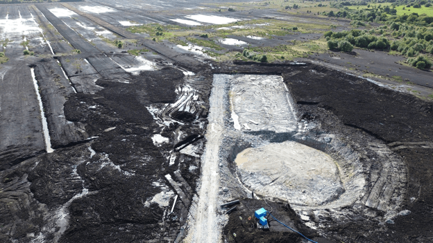
It is difficult not to be disturbed and distressed by the images below which shows excavation in progress for a wind turbine base in Clongawney bog. There is an enormous amount of destruction and disruption for a relatively small base. And what makes the situation much worse and even more disturbing is that the turbine is clearly located in bog wetlands. In a few years this area will be covered in vegetation and will be home to a variety of wildlife. And right in the middle will stand a massive turbine with massive blades. The bogs are special places. They have suffered so much over the last 70 years. Ignorance and necessity may be the explanation for what happened. However there is no excuse now. This is permanent destruction of our bogs. How can this be allowed to happen ?
Below are photographs of the works at Clongawney Bog near Banagher and the works which must conflict will all our plans to protect the natural environment.
CLONGAWNEY IS LOST. DERRINLOUGH IS LOST. LEMANAGHAN IS NEXT.
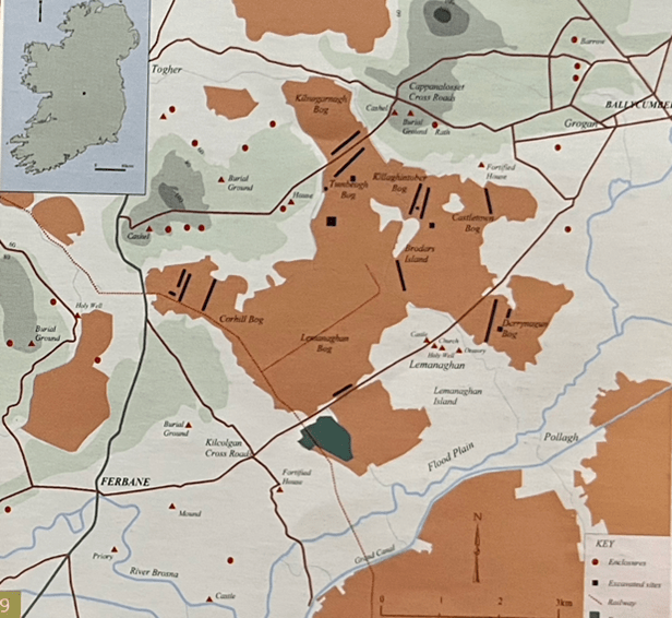
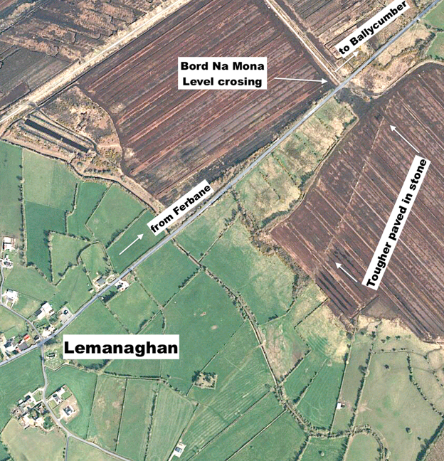
There can be few places in Ireland of more historic importance than Lemanaghan. The image above shows the location of several toghers which have been found on Lemanaghan Bog. Amazingly the largest togher on Lemanaghan can be seen clearly from space! Click on the Google Earth link and be astonished.As can be clearly seen from the map above the bog is criss-crossed with ancient toghers and holds an array of archaeological sites. It would be unthinkable to put wind turbines on the callows or the eskers or the bogs that surround
Links in higher resolution to some of the pictures below.
This is a dramatic way to show this fabulous togher Lemanaghan Togher
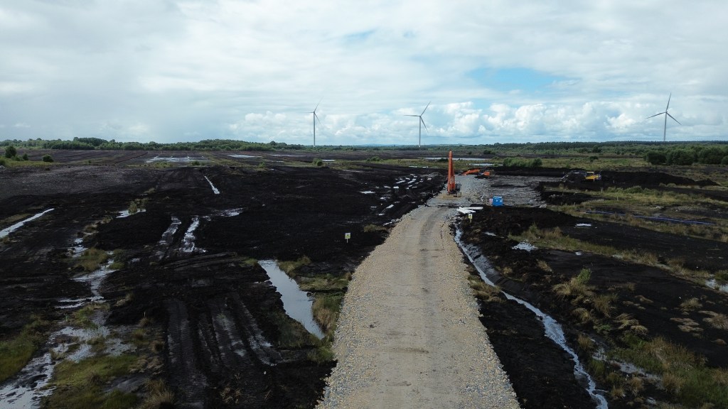
The massive dumper which can be seen on this image helps size this extraordinary motorway type junction on Clongawny Bog. This motorway/roadway will only be used once to transport the components for a turbine and then….? To comprehend the scale of what is happening you need to visit to Clongawny.This find took place a few weeks ago on Clongawny Bog, just a mile or so from Banagher. Note wind turbine construction activity in the background. It is piece of timber with at least two square holes worked by human hand, possibly two thousand years ago. The piece is located on the side of a drain about half metre below the bog surface. No doubt there are many more precious archaeological artefacts and sites awaiting discovery in Clongawny and Lemanaghan and in other bogs.This image shows an extensive deposit of bog iron ore also on Clongawny Bog. In the background are tens of thousands of stone are being poured onto the bog surface.
Bord Na Mona Bogs in 2023 A Brief Summary
Peat harvesting ended in 2020 but finished on many bogs more than 20 years earlier. There is at least 1 metre of bog remaining on all bogs and more than 2 metres in most places.
Return to nature
A wide variety of vegetation has become established on many bogs with little interference from anyone with the possible exception of the blocking main drains. Drinagh is now a beautiful area of perhaps 1000 acres with wide expanses of vegetation interspersed with water and inhabited by a variety of wild life.
Rewetting
Extensive ‘rewetting’ has been carried out on a few bogs. This mainly involves the construction of ‘berms’ about 3/4 metres high and up to 7 metres wide thereby dividing the bog into fields a few acres in size. The berms prevent water runoff and hopefully in time will lead to growth of sphagnum moss. This system is totally dependent on rainfall and long dry spells will be a significant test as well as fire risk when berms dry out. Derrinboy bog is a good example and is easily accessed from the Kilcormac- Kinnitty road.
Wind turbines
Wind turbines were erected on Mount Lucas bog a few years ago and are now in progress on Clongawney and Derrinlough bogs. Because of the heavy and sizeable components a grid of motorway type roads have to be constructed on the bogs. These are supported on mats of very heavy duty plastic as bogs are not capable of taking weight. On completion access is secured and controlled by BNM. If Mount Lucas is taken as an example wind turbine farms will not be an attractive place to visit unless cycling or walking on 7 metre wide ‘straights’ can be considered exciting. There is a real fear that at some point in the not too distant future BNM wind farms will be packaged and sold off to international investor funds.
Tracks and Trails
Substantial state funding is now available to help make the 10s of 1000s of acres of post peat harvesting bogs interesting and attractive places to visit for locals and visitors. The management of this fund seems to rest entirely with BNM. There are hundreds of kilometres of bog rail track which can be easily made into walking and cycle ways. All of the bogs have raised headlands where no harvesting took place and these are ideal and save places for cycling or walking. It is important that those playing a role in the design of this project have a familiarity with and sensitivity to the bogs and to the locality.
Early in the summer of the year 697, probably in May, a great assembly of kings, bishops and abbots, along with their followers and servants, took place in Birr. It was a joint meeting of kings (rígdál) and of church leaders (synod). They came together to proclaim a law for the protection of women, children, clerics and other people who did not bear arms, in times of conflict. The law was called Cáin Adomnáin or the ‘Law of the Innocents’ (Lex Innocentium) and later referred to in a poem as the ‘Great Law of Bir
Mag Léna is of interest for two events that occurred in the early historic period. The first event is the pseudo historic Battle of Mag Léna. The second event was the significant Synod of Mag Léna and the Letter of Cummain, part of the Irish church row with Rome over the dating of Easter.
Both incidents caused a split in Ireland!
What’s in a name?
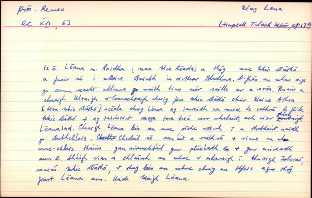
Mag Léna is mentioned in logainm.ie as Moylena and places it in the parish of Kilbride, Co. Offaly. Mag or Magh translates as a plain or open country, there is no information provided on the meaning of the word Léna. Unusually, there are no additional references other than the basic location details, also this older relic from the original card index system below. A 13th century manuscript mentions Cath Mhuighe Léana. Magh Léana is mentioned elsewhere. In his Survey Letters we find O’Donovan used a variety of spellings for the name – Moylena, Moyléna, Moyleana, Moleany and Moy-leana.
Logainm index card for Mag Léna.
As usual there are difficulties with the older Gaelic placenames and how they were recorded over time. Today the only memory of the name is in Tullamore, where the Moylena road joins the Clara Road and eventually joins the Rahan Road through Glendaniel.
Contributed by Offaly History to mark the occasion
The new book, St Manchan’s Shrine, by Griffin Murray and Kevin O’Dwyer was launched to great acclaim by the CEO of the Heritage Council Virginia Teehan on Friday 21 October 2022 at Offaly History Centre, Tullamore before a large and distinguished audience. Proceedings began at 5 30 p.m. with Amanda Pedlow ably acting as chair and introducing the four speakers. First was the author of the text Griffin Murray, followed by silversmith and photographer Kevin O’Dwyer. The County Offaly CE Anna Marie Delaney skillfully chartered the progress being made in regard to the county’s heritage while CEO Virginia Teehan paid tribute to the county for its wide-ranging involvement in heritage projects and availing of the funding available. The new Offaly Archives was a leading case but one among many successful projects undertaken. Another is that of the funding received to create the post of a biodiversity officer. Offaly has demonstrated its ability to secure funding for projects and that was a reflection of the work being done in the county. Ms Teehan congratulated the authors, Griffin Murray and Kevin O’Dwyer, on a job well done. Yet another exemplar.
The earliest writing is recorded in eastern Asia about 5,000 years ago. The spread was westwards with the use of earthen (cuneiform) tablets that are still found today in the Tells of modern Iraq and in the Fertile Valley. Cuneiform tablets were mainly used for recording stock control items and account balances; at the same time Egyptian hieroglyphs were starting to record the stories of the Pharaohs.
Cuneiform and Hieroglyphs
The Greeks and Romans introduced writing to the Mediterranean countries and it spread across Europe to Britain with the arrival of the first Roman invasion in 55BC.
Ogham is the first recorded writing in Ireland, based on inscriptions on stone. Ogham is a language based on the Roman alphabet. The influence of the Roman empire had introduced the Latin language and writing to most of Europe. Only two other societies used stone – Pictish symbols in Scotland and Norse Runes in northern Europe. Ogham stones are found in Ireland and in the Irish areas of influence in Scotland and Wales.