The Grand Canal reached Daingean in 1797. The changing landscape along the route of the new canal from Edenderry at its survey in 1800. Sir Charles Coote describes Philipstown /Daingean in No. 33 in the Grand Canal Offaly Series
The Grand Canal reached Daingean (Philipstown 1557-1920) in 1797 having been dug by upwards of 3,000 men from the access to the county at Cloncanon, Edenderry in about 1793. The next stage was making the line from Edenderry to Rhode, Toberdaly, Killeen bridge and into Daingean where the Molesworth bridge was built in 1796. After that it was on to Ballycommon, the 26th lock (Boland’s. ‘the Round House’) and the drop down all the time to Tullamore which was reached in 1798. The fall over the eight locks, from no 21 to no 28 at Clara bridge, Tullamore was about 73 ft. It was five years before the connection from the main line of canal at Cloncanon and Drumcooly was completed to Edenderry in 1802.
Coote in the survey published in 1801, dedicated to none other than General Vallancey who had surveyed the proposed line of the Grand Canal as far back as 1770 (see an earlier blog), was able to describe the scene close to the line of new canal of which so much was expected.
Tullamore is the county town of Co Offaly, it lies on the Grand Canal. It is a large and thriving place that has seen great development over the years. In this article, have a look back with a picturesque timeline through from 1798 when the canal reached Tullamore. We will return to Tullamore stories of the canal when the east west tour is completed.
Kilbride Parish: Seven Miles from East to West. The Parish lies in the ancient O’Molloy territory of Fir Ceall, or Men of the Church. It contains main archaeological sites some of which have sadly been destroyed or taken back by nature.
Tullamore is in the Electoral Division of Tullamore Urban, in Civil Parish of Kilbride, in the Barony ofBallycowan, in the County of Offaly. The Irish name for Tullamore is Tulach Mhór meaning Great Hill. The rising ground in Tullamore leads to the hill at High Street – Cormac Street.
The Civil Parish of Geashill is the largest Parish in Offaly, and contains 74 townlands. As well as fine fields and bog land – dark, shale and lime mudstone, are just some of the materials you will find in its bedrocks.
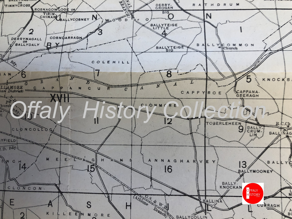
The Parish is part of the ancient territory of “Ui Failghe of the O’Connor chiefs”. It contains some of the oldest remains of castles and is rich in history. From ancient sites such as Enclosures and Ringforts. Sadly many of them have been lost due to nature elements and neglect. It contains the town land of Cappyroe which borders the Grand Canal line, it is the 293rd largest townland in Co. Offaly and in Irish is Ceapach Aodha Rua, translation meaning Plot of Land[2].
Map of the townlands from Ballycommon to Tullamore. There are over 1,000 townlands in Offaly. See townlands.ie for more.Your walk along the canal from Ballycommon will see you visit Cappyroe, Clonmore and Cappancur
In 1911 Cappyroe had one of the lowest concentration of houses in the area, during this period the household returns and ancillary, shows us that the population decreased from 106 in 1841 to 21 in 1911. There were 6 houses on record, all of all of Private Dwelling, with all inhabited, with classes of houses between 1st and 2nd . Age of occupiers ranging from 1-80. Here are the families that occupied these buildings during this time:
As we make our way along the line, we come to lock 22nd, which was previously mentioned in the last series of “East to West”. The 23rd Lock is followed close behind. A smooth and clear pathway can be found, making it easy to walk or cycle along the way. Coming up we see the 24th Lock. This lock is located near the former Celtic Canal Cruisers. We are preparing an article on this canal attraction, 1974-2004.
(08. Celtic Canal Cruisers / Image Source/ Offaly History). We are preparing a blog on this important cruise line. Can you help with material?
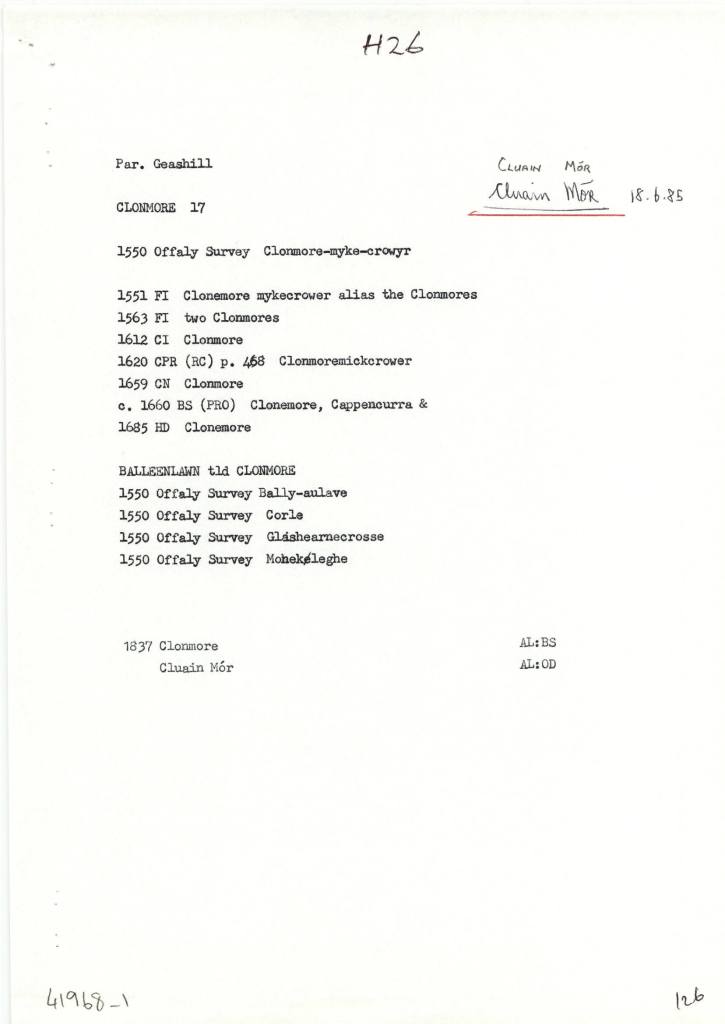
Clonmore (Cappancur), in the Civil Parish of Geashill, in the Barony of Geashill, in the County of Offaly. The Irish name for Clonmore is Cluain Mór meaning Great Field.
Clonmore is the site of a few known churches the Balleenlawn Church that stood until the early 19th century. Its Foundation, was discovered in 1942. It also contained an old graveyard that is still intact today[3].
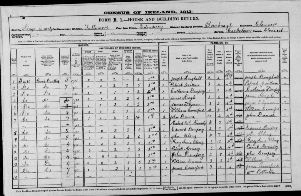
In 1911 Clonmore had 26 houses in the area, during this period the household returns and ancillary, shows us that the population decreased from 220 in 1841 to 101 in 1911. There was 26 houses show on record all of all of Private Dwelling, with all inhabited, with classes of houses between 1st, 2nd and 3rd. Age ranging from 1-80. Here are some of the families that occupied these buildings during this time:
(15.Coachman, source Travel and Transport in Ireland, Edited by Kevin B.Nowlan)
With the construction of the Grand Canal it provided a better connection to reach different townlands around the country. With many place still not connected by waterway, the coach services provided that connect for passengers to reach their final destinations.
As we make our way out of the Geashill Civil Parish, we reach the 25th Lock and Just at Digby Bridge, here we can see just the spire of Tullamore’s Catholic church. Close by is the 26th lock, the barony bridge with its passage under the canal and on to Tullamore. More on Wednesday.
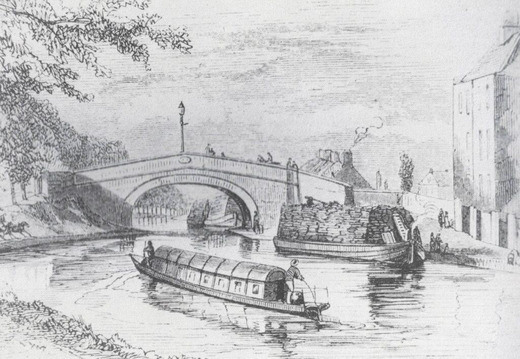
Flyboats on the canal in the 1830s, similar to the later design of the Celtic Cruisers fleet of the 1970s
[1] See “Safe Harbour, The Grand Canal at Edenderry” Mairead Evans & Therese Abbott” Topic Newsppapers Ltd, P22-23
[2] Offaly thought Time & Its Townlands. Thomas Lee. Pub: Ottait Publishing p173
[3] Offaly thought Time & Its Townlands. Thomas Lee. Pub: Ottait Publishing p173
There is an open invitation to all those interested in the River Brosna to come to the book launch on Friday 22 March at 7.30pm in The Star (GAA hall) River Street, Clara hosted by Clara Heritage Society.
John Feehan has dedicated much of his life to studying and communicating the evolution of the landscape and how we have lived in and changed it – his previous Offaly publications have included books on the Slieve Blooms, Croghan Hill, the Landscape of Clonmacnoise, An Atlas of Birr and more recently Killaun Bog and the Camcor River. This new publication focuses on the River Brosna and its catchment.
The River Brosna is one of Ireland’s hidden rivers, glimpsed over bridges and for short stretches as it travels through Mullingar, Ballinagore, Kilbeggan, Clara, Ballycumber and Ferbane on its journey from Lough Owel to ShannonHarbour. Until now very little has been written about it yet few rivers have a more fascinating and varied story to tell. In this beautifully illustrated book John Feehan brings his long experience as an environmental scientist and historian to bear on all aspects of the natural, cultural and industrial heritage of the river and its catchment. Successive chapters review geological origins, the biodiversity of the river and its tributaries as well as the great area of bogland it drains. The history of the mills along the course of the river, and of the two great arterial schemes that so altered the river are reviewed and particular attention is devoted to the extraordinary stories of Mesolithic Lough Boora and the Bronze Age Dowris hoard.
As we make our way along we start to make the journey to Ballycommon, we come to Townparks townland, in the Electoral Division of Daingean, in Civil Parish of Killaderry, in the Barony of Lower Philipstown, in the County of Offaly. The Irish name for Townparks is Páirceanna an Bhaile. Townparks townland in Daingean has the site of Fort Governor which was built in 1547 on the site of an O’Connor Castle stronghold.
along this line we come to one of the gems along this way, the Bord Na Mona lifting Bridge, It’s an interesting spot and a great location to get the camera out. From the late 18th century, the canal was used as a way to transport turf from different cutting points along the line. As trading long the canal was increasing rapidly and was even more encouraged when charges were abandoned, the one that was always a difficult trade to control was the “Turf”[1].
03. The half-inch of c. 1910 from Philipstown to Ballycommon and Cappancur Offaly History Centre. Showing also the Kilbeggan Line of the 1830s.
A few incidents along the line was reported, before the construction of the Circular line, including situations where turf traders, held up and demanded change to the dispatching and the price of turf. After a standoff with an angry crowd, that were armed with swords and guns. The canal company, compromised with the people and ordered that all boats display a clear sign with the price of their turf.
During this time quays were used along the canal to unload turf and an inspector was appointed to see the overall control of the Turf trade. By the early 19th century, a steady flow of boats travelled up and down the line, with up to 33,000 tons every year arriving for dispatch. G- Boats were the main boat used when transporting product and with a fixed toll now applied to all traders, this encouraged the use of greater loads.
Michael Hoy was born in Daingean county Offaly in the year 1834 to William Hoy and Rosanna Concasey. His father died when he was a young boy. In 1853 he emigrated with his mother, brother William, and two sisters Rosanna and Elizabeth, settling in Brooklyn. His older brothers Joseph and John, along with another sister Mary had gone to America a few years before. Michael Hoy learned the stone cutters trade in Brooklyn. In 1854 the family moved to Cooperstown, New York, which is two hundred miles north of the city. Young Hoy worked in his trade for one more year before returning to Brooklyn. In 1857 he went to Minnesota, settling in the town of Saint Anthony. At this time Saint Anthony had a few scattered houses on the east bank of the Mississippi river. He followed his trade and the same year of his arrival he cut stone for the building of the State University.
In March 1914 the Foresters Hall played host to meeting called organise the Irish Volunteers in the district. Following the outbreak of the Great War and the resulting divisions within nationalism, the Tullamore Corps of the National Volunteers gathered at the Foresters Hall to reaffirm their support for John Redmond. The Foresters branch secretary James Hayes joined the 5th Lancers in early 1916.
In December 1915, the Ideal Cinema was the venue for a screening of ‘Joan of Arc’ in aid of the Red Cross. Two months later, the Urban Council arranged a reception at the hall to present an address to captain Edward Sherlock after the Rahan man was awarded a military cross for his actions on the Western Front. As late as February 1918, the hall hosted a lecture by Henry Hanna KC on ‘The Pals (7th Dublin Fusiliers) at Suvla Bay’ in aid of the Leinster Regiments Prisoner of War fund. Nevertheless, by then the Foresters and their hall had come to be associated extreme nationalism in the mind of some within the police.
A programme for the Foresters in 1916
At a show the hall in on St Patricks Day 1917, a twelve-year-old girl Lena McGinley dressed in a ‘Green, White and Yellow’ costume performed a poem dealing with the 1916 Rising entitled ‘Vengeance’. As a result, sergeant Henry Cronin had the concert organisers James O’ Connor and Edward O’Carroll charged under the Defence of the Realm Act (DORA) for ‘attempting to cause disaffection among the civilian population ‘. On their conviction O’Connor and O’Carroll refused to be bound to peace and were instead imprisoned in Mountjoy.
The weather was bad when Joseph Hutchinson arrived in Tullamore. For 22 years Hutchinson had dedicated himself to the Irish National Foresters and as a result a small mutual aid society founded by 18 men in Dublin, had spread across the globe and recruited over 20,000 members in Ireland. On Sunday 9 April 1899, Hutchinson had come to the midlands to recruit some more members and establish the first INF branch in King’s County. His visit that day would have profound repercussions for Tullamore, but it had its roots in the north of England.
Today with the canal being a popular walking destination, you can see along the canals places associated with the townlands . Just outside Rhode, on the way to Edenderry, are the ruins of old windmills of the eighteenth century. These once had a wind shaft mounted in the cap (one is preserved at the Guinness brewery and was used by the Roe distillery). The wind turned the millstones in the tower below and were used to help ground grains for flour.
Seven windmills are known to have been constructed during this period in Offaly. By 1830, most of the windmills had gone out of service. The last windmill to be used was dated up to 1880, called the Fahy Windmill[1]. Tullamore had two in the eighteenth century on the hill behind O’Moore Street.
Along our Grand Canal Journey from Edenderry to Shannon Harbour we come to Rogerstown, a small townland, in the Electoral Division of Monasteroris, in the Civil Parish of Monasteroris, in the Barony of Coolestown, in the County of Offaly.
The Irish name for Rogerstown is Baile Risteird meaning Richard’s/land.
(01.Monasteroris civil parish from the Index map Kings’ County 1838. Image source Offaly History Centre)