This week we have a blog provided by Eduardo García Saenz (member of Champagnat Rugby Club, Economist, Journalist and Sports’ Historian, especially in rugby, soccer and horse Polo. In this article he is presenting about THOMAS St. George ARMSTRONG (1797-1875); born in Garrycastle, near Banagher and who made a fortune in Argentina. His son bought Garrycastle House, Banagher in 1890 and is in Burke’s Landed Gentry 1912 edition with lands in Garrycastle and a residence in Paris. This is our last blog of this year and so far we have achieved 103,000 views for our blogs since 1 Jan. 2020. Thanks contributors and readers for all your help and wishing you all the best in 2021. Like our blog to ensure you get it every week per an email advice. All our blogs can be found at Offalyhistoryblog and our web platform http://www.offalyhistory.com. We post them every week to Facebook and Twitter (Offaly History).
Eduardo García Saenz
Eduardo is the the great-great-grand child (Chozno Grandson) of Thomas Armstrong who died in Buenos Aires in 1875. Eduardo has visited Dublin and Malahide, but has not yet had the opportunity to visit Banagher, Birr and Tullamore. He is aware of our ‘delicious Irish whiskey and also the malt’. In rugby he knows that there are two good rugby clubs in Co, Offaly: Tullamore RFC and Birr RFC.
Eduardo writes that the Armstrong family gave the land in Banagher to build St. Rynagh’s Church in 1826 and donated the bells for the church. Thomas Armstrong was also a donor to the Catholic church in Banagher in 1873 (King’s County Chronicle, 20 Mar. 1873). In 1847 he donated £50 to support famine relief in Banagher and Lusmagh, and later to the Crimean War Fund.
We would welcome blogs from overseas on the contribution of people from the midlands of Ireland in their adopted country (to info@offalyhistory.com). We draw attention to the Dictionary of Argentina Biography and the like for Australia. These are now online. The Irish DIB goes on line free in 2021.
Offaly History intended to have a walk on 26 December 2020 through the historic Lloyd Town Park, Tullamore, but had to cancel due to the imposition of the third wave of restrictions since March 2020 designed to reduce the impact of the Covid-19 virus. An historic year and one we will be glad to see the back of. After fifty-years of mostly progress since the 1960s we have become accustomed to the shock of change for the worst since the banking crisis and the bail-out. Now it’s the Covid-19 virus and in the background climate change, and in Offaly the end of the bogs – so much a part of growth in Offaly from the 1950s. Today we are visiting the Lloyd town park, Kilcruttin, Tullamore and reflecting on its historical features and change in the landscape of the area and the town of Tullamore since the 1700s.
The park area in 1838 on the six-inch scale with Water Lane, gazebo and the new courthouse and jail. A second Methodist church was located in Crow/Tara Street from the 1820s to 1877. The landscaped gardens of Acres Hall can be seen on Charleville Street, now Cormac Street.(more…)
Many readers and their parents will have great recollections of the dancing scene in Ireland. You can help write the history. Share your thoughts and send on the stories needed to build a picture of the dancing scene in Ireland. Many will recall Je t’aime played in the 1960s in St Mary’s Hall, or the Harriers, Tullamore. But what about the County Ballroom and the parish halls in Clara, Birr, Rahan, Killeigh and so many more. Did dancing bring about the ‘ruin of virtue’?
Dancing has always been a source of expression, fun and entertainment in Ireland. People danced at the crossroads, in each other’s houses, at social events, festivals, and in licensed dancehalls all around the country. From the early twentieth century the Catholic hierarchy became particularly concerned with the opportunities that might arise for sexual immorality in dancehalls. In October 1925 the bishops and archbishops of Ireland issued a statement which was to be read at ‘the principal masses, in all churches on the first Sunday of each quarter of the ecclesiastical year.’ The statement referred to the ‘evils of dancing’ and it was ‘a grave and solemn warning to the people with regard to the spiritual dangers associated with dancing’. The statement noted: ‘We know too well the fruit of these [dance] halls all over the country. It is nothing new, alas, to find Irish girls now and then brought to shame, and retiring to the refuge of institutions or the dens of great cities. But dancing halls, more especially, in the general uncontrol of recent years, have deplorably aggravated the ruin of virtue due to ordinary human weakness. They have brought many a good innocent girl into sin, shame and scandal, and set her unwary feet on the road that leads to perdition’. The behaviour of the men did not elicit much comment. From the mid-1920s and throughout the early 1930s there were constant references in the newspapers to the problems of dancehalls and motor cars. In 1931 Cardinal McRory combined the two and saw a growing evil in ‘the parking of cars close to dancehalls in badly lighted village streets or on dark country roads. Cars so placed are used … by young people for sitting out in the intervals between dances’. ‘Joy-riding’ had a very different connotation in the period than it does now. Reporting on a sermon by the bishop of Galway, the Irish Independent noted that ‘joy-riding’ was conducted by ‘Evil men – demons in human form come from outside the parish and outside the city – to indulge in this practice. They lure girls from the town to go for motor drives into the country, and you know what happens… it is not for the benefit of the motor drive. It is for something infinitely worse’.
The modern official street-names of Tullamore town were adopted by the Tullamore Urban District Council in the early 1900s, replacing earlier street-names which were used in the nineteenth century and often adopted in honour of the town’s principal landlord, Charles William Bury (1764–1835), the first earl of Charleville (second creation). He presided over the fortunes of the town in its most formative phase from 1785 until his death in 1835. These honorific names replaced in some cases other more functional names used in the eighteenth century.
The street-names are generally as follows: first the functional name, e.g. Pound Street, secondly the landlord’s choice of name (post 1785 to c. 1905) such as Charles Street, William Street and Bury Quay. After 1905 the choice of Tullamore Urban District Council, i.e. Columcille Street, Clontarf Road and Benburb Street, O’Carroll Street, O’Connor Square. The council, at the behest of the Gaelic League, adopted names based on local saints, families and famous Irish battles where the Irish won, or put up a good fight. The only example of a marketing name is that of Main Street (2003) and formerly known as Water Lane.
Some of the nineteenth-century names are still in use, for example, William Street. Whereas, Patrick Street is now seldom called Barrack Street as it was up to the 1960s. Henry Street (1820s) is after Henry Bury, a child of the second early of Charleville, who died in 1830 at a young age. Henry Street is still much used instead of the post-1905 official name of O’Carroll Street. The earliest names were related to the function served such as Market Place from about 1713 for the present O’Connor Square, Pound Street for the present Columcille Street. These functional names were later replaced by names paying homage or regard to the owner of the town, the Moore family and post 1764, the Bury family. Even the name of the town was amended to read Tullamoore instead of Tullamore, something that came into common use during the time of Charles Moore, first earl of Charleville (of the first creation of this title) and who died childless in 1764.
The name Tullamore can be documented back to 1571 and there is an earlier reference in a Life of Colmán. The great resource for Irish placenames in now online at logainm/placenames.ie. Here is a copy of the archival record for Tullamore, also called Tullamoore from the 1670s to the 1850s.
So where is the big hill – Hophill or Windmill Hill behind O’Moore Street?
The archival record from placenames.ie for Tullamore
Enter the Gaelic League
The matter of the new names for the streets had come up at town council meetings in December 1904 and again in January 1905 and February of the same year. It was the Gaelic League (founded as to the Tullamore branch in 1902) who suggested to the council the appropriateness of new names reflecting the local saints, local native families and episodes in Irish history, and to be erected bilingually. On the proposal of John Wrafter and seconded by James Maher the changes were adopted. It was not difficult to see why the choice of names of the landlord or his agent should be disposed of. The good standing of landowners, had diminished during the Land War of the 1880s. Lady Bury had succeeded her uncle as owner of the Charleville estate in 1875, but being a woman and after 1885 a widow she was at a disadvantage. Furthermore she was very much an absentee and left matters to her agent, Ernest Hamilton Browne. Following the pattern set at national level in the 1890s the language, history and traditions of ‘Irish Ireland’ came again to be appreciated as a culturally distinguishing feature that separated the native from the foreigner. In Tullamore the Gaelic League enjoyed a strong period of growth after 1902 and during the tenure as president of local solicitor Henry James Egan, the delicate second son of Henry Egan, the town’s leading nationalist and merchant of the firm of P. & H. Egan Limited. Henry James Egan qualified a solicitor in 1900 and as coroner and county solicitor from 1903 was prominent for his few remaining years. He died in 1907 at the age of 29.
Among the streets and lanes closed before 1900 were: Emmet’s Lane, Willis’s Lane, Flanagan’s Lane, Molloy’s Lane and Sally Grove. The availability of the 1901 and 1911 censuses online makes all this information on families and streets so accessible.
As to the names we will have to come back to review them in more detail. Names such as Bachelors Walk, Chancery Lane and Swaddlin Lane. The latter is accessed between the two Italian restaurants in Patrick Street. The first Methodist church was in this lane until destroyed in the Balloon Fire of 1785. Every street and its name have a detailed history such as this paragraph on Brides Lane formerly Ruddock’s Lane or Swaddling Lane. The early Methodists were often called Swaddlers.
Bride’s Lane (Patrick St N.). Swaddling Lane 1821 (FDJ). Ruddock’s Lane 1838, 1890; Brides Lane 1912 (OS). One-storey houses each side (OSN 1885).The home of the first Methodist chapel c. 1762 (Craig, 1907; see Methodist chapel). Ruddock was a property owner with a dwelling house to the front of the street (OHA, 24 Mar. 1786, lease, Bury to William Ruddock). Described as Ruddock’s Lane (RD, 18 Mar. 1833, Ruddock to Wade, 1833/9/73). 38 cabins in 1843–54 (Val.1, Val. 2). 87 inhabitants in 1901 with 27 houses and 27 families (Census). The modern name is derived from the name of the parish, Kilbride. In giving evidence to a housing inquiry in 1910 it was described as a very congested district surrounded by a high wall with no thoroughfare through it (MT, 3.9.1910). It later became known as the Wade estate and was sold in 1912 (TKI 2.11.1912). The name Ruddock’s Lane was still in use in 1918 when twenty-five cottages here were offered for sale of which twenty-four were weekly tenants paying 1s. 4d. per week (TKI 30.3.1918). Clearance order published for demolition of dwellings (MT 21.12.1935). Now it the home to the name provided by the developers – Haviland Court.
Another interesting name is that beside the Bridge Centre known as Distillery Lane.
Distillery Lane: This lane is now greatly changed and was made into a wide street in 1992 as part of the construction of the Bridge Centre. It was known as Parvin’s Lane in 1783 and later Still Yard Lane. It connected Bridge Street with the distillery in use from the 1780s to 1954. In 1995 the lane was greatly widened to facilitate access to the new Bridge Centre. The widening followed on the demolition of the former Hoey & Denning premises in 1992 and was carried on to Water Lane off Patrick Street and after 2000 to Main Street.
The old street names coming down in 2000 courtesy of Michael Hayden
John O’Donovan stayed in Banagher from 10-21 January 1834 where he was accompanied by Thomas O’Connor. As mentioned in a previous blog he used his time there to look at two historic sites in particular, in addition to his normal work. He first concentrated on Clonmacnoise, writing his first substantial and detailed letters on 15 January 1838. This followed on from his request that documents be sent from Dublin ahead of his arrival. He had visited Clonmacnoise and had collected a considerable amount of information about the church site and general area.
He first concentrated on the individual monuments on the site as detailed in earlier manuscripts and associated the monument to the relevant family names. His local contact was a man named Patrick Molloy but O’Donovan was sceptical about the accuracy of the information provided by him. In addition, he dealt with the map produced by Sir James Ware dated 1705; on this map Ware had identified 10 churches at Clonmacnoise, see below. For each monument O’Donovan checked the age of each as indicated in the Annals, checked the background of each one and compared that to a report in Petrie’s possession. (more…)
The architect and town planner Frank Gibney (1905-1978) is today recognised as one of the most talented, influential and prolific housing designers of mid-20th c. Ireland.
Responsible for almost six thousand local authority dwellings in every part of the country, his deep concern for human scale and for good living standards delivered homes of a quality which have stood the test of time, while today many of their contemporaries have been altered or demolished.
Principal amongst his many achievements are the six Midland bog villages built in the 1950s for Bord na Mona workers, which were inspired by the aspirations of Patrick Pearse and Eamon de Valera for national self-sufficiency and which have been described by the Yale University Press/Royal Irish Academy volume on Irish architecture as ‘models for rural living’. These beautiful urban set pieces are cherished by their proud present day inhabitants and beg the question as to why contemporary housing policies have not emulated their success.
Gibney designed housing estate at Clarecastle, County Clare
Gibney’s numerous and extraordinarily ambitious town planning schemes founded on Garden City and Beaux Arts principles, were less successful, being proposed at a time of cultural conservatism and financial stringency. His passion for plans based on aesthetic principles which would preserve the best of towns while creating new and beautiful public areas found little local response. Nonetheless, he was engaged by many Irish towns and cities including Waterford and Drogheda to chart their future and elements of his proposals are still capable of fulfilment today.
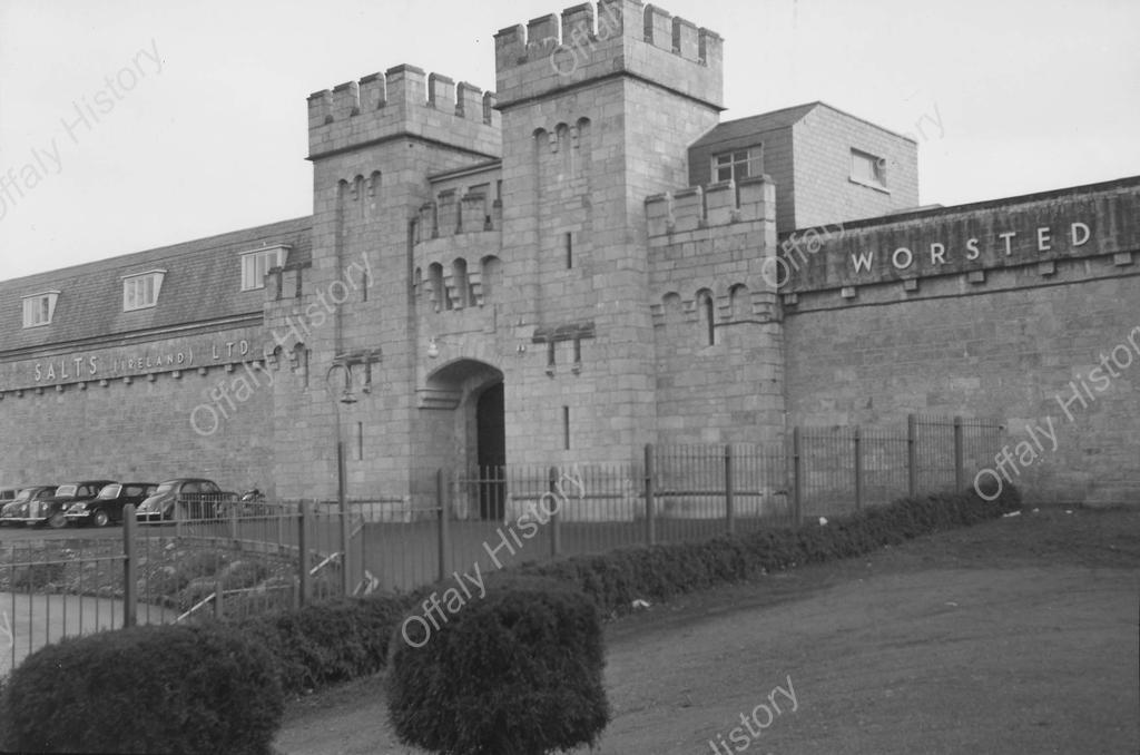
In the week of 23 December 1978, the Tullamore Tribune published an interview with the late John Carroll on the history of Salts/Tullamore Yarns. He had been with the company for its full forty years in Tullamore. The Tribune noted that John Carroll might be called the ‘Bill Riley of Tullamore Yarns’ – which means, as fans of the popular television serial of that time ‘The Brothers’ will realise, that he came into the firm at the bottom, without any special advantages, and worked his way up on merit alone. He made his appearance on the scene as a young teenager, helping to unpack and clean the machinery arriving for setting up of the Salts textiles factory in 1938. By 1978 he was works manager. He took a keen interest in Tullamore and was for many years a director of Tullamore Credit Union.
Salt’s spinning mill, erected on the site of old Tullamore jail, was the largest employer in Tullamore for about thirty years. Prior to its completion in 1938 there had been no major factory in the town from with the loss of the Goodbody tobacco factory due to a fire in 1886. Any tradition the town had in textiles was gone since the 1820s. A linen factory building had been constructed in 1754 but was out of use by 1800. Salts decided on Tullamore after making a short list of suitable towns, interviewing the town council and satisfying themselves in regard to the site at the old jail which had been largely destroyed in 1922 during the civil war. Nothing could have been done without the support of the townspeople, William Davin, TD and the Minister for Industry and Commerce Sean Lemass.
Salts/Tullamore Yarns 1937-82
The owner of the new woollen mill was Salts of Saltaire in Yorkshire and employed 3,500 workers in the textile industry. Salts (Ireland) Ltd. was established in 1937 to supply the requirements of the Irish market in worsted yarns both weaving and hosiery. The leading figure on Salts’ side was R. W. Guild who was from Scotland. At about the same time as Guild was establishing Salts (Ireland) William Dwyer, the founder of the Cork-based Sunbeam Wolsey, was working to develop his own plant.
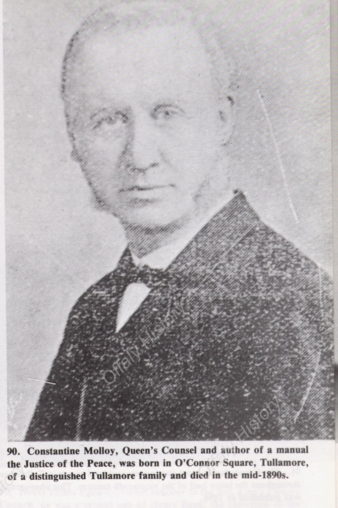
The Molloy family in Tullamore have distinguished antecedents and can include among their number two of the town’s most prominent citizens in the 1820s to the 1840s, Michael Molloy and Anthony Molloy. Michael Molloy founded the Tullamore Distillery in 1829 and from it came the Bernard Daly distillery and that of Tullamore DEW. Michael Molloy was a patron of schools and of the new Mercy convent of 1838-40. The family were the owners of Tullamore up to the 1620s and were the principal landowning family in the baronies of Ballycowan, Ballyboy and Eglish until the Jacobite and Cromwellian plantations. Some such as Charles Molloy had extensive landholdings at Greatwood in Killoughy up to the 1850s. Constantine is a recurring name in the family and one of our regular contributors to this blog, Cosney Molloy, is proud to be called after an early king of Cornwall. Kilcormac and Rahan are strongholds of the family.
The well-known geographer, T. W. Freeman, provided us with a useful summary of the work in the Tullamore bacon factory in his geographical survey of Tullamore published in 1948:
An advert of 1965
The Midlands Co-Operative Society began its career as a creamery in 1928, and was at first intended to absorb the milk supplies of the neighbourhood for butter – making, but as these were never sufficiently great the trade in eggs and poultry became more important. Like the two private firms mentioned above [Williams’s and Egan’s], the Co-Operative Society buys and sells over a wide area, which includes the two counties of Leix and Offaly, the whole of Co. Galway, and parts of Tipperary, Roscommon, and Meath . Altogether the Society handles some 30,000 cases of thirty dozen eggs, of which three-quarters are exported to Britain, and approximately 24,000 turkeys, 5,000 geese, and 18,000 hens per annum, mainly for export or the Dublin market. Butter is bought from other creameries, made into one – pound rolls, and sold. In 1945, a bacon factory was added; the pigs are bought in Co, Offaly, and the produce sold in much the same area as that covered by the eggs and poultry trade. The scarcity of pigs at present means that the factory is working below capacity. The Society also has a sawmill using local timber for making cases and firewood and runs retail shops in Tullamore town and at Clonaslee: in all, it employs 180 workers, with 80 extra in the Christmas turkey season, and 20 extra in the main egg season, from February to May: most of this labour is drawn from the towns.
Townlands are the smallest official unit of administration in Ireland, followed by the Parish. Our townlands are ancient divisions and some have existed under other names since pre-Christian times.
By the early 1800s, local taxes were based on the valuation of townland units. These valuations were based on hopelessly obsolete information and poor mapping, and it was necessary for the boundaries of townlands to be mapped accurately in order to provide a framework for new valuations. There are 64,642 townlands in the Republic of Ireland, with over 1,000 in Offaly.
The Duke of Wellington authorised a survey of Ireland in 1824 in response to requests from his brother, the Marquess of Wellesley, who was Lord Lieutenant of Ireland at the time. The task was given to Lt Col Thomas Colby and officers and sappers of the Royal Engineers with civil assistants. First established as a military office, all the staff were military employees until the 1970s, when recruiting of civilians started.
It was decided to carry out an experimental triangulation survey in 1824, using Ireland as a test area. When completed the Irish survey would be a model for Great Britain and other areas of the Empire. The aim of the survey was to standardise and anglicise the representation of the Irish landscape. (more…)