
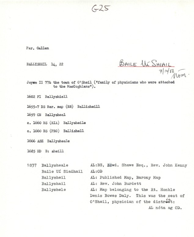
Ballysheil is in the Electoral Division of Gallen, in Civil Parish of Gallen, in the Barony of Garrycastle, in the County of Offaly. The Irish name for Ballysheil is Baile Uí Shiail meaning the town of O Siail.
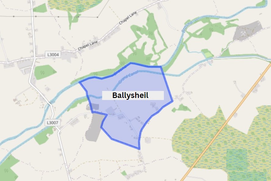
In this area we come to two smaller bridges, not far part from each other. Glyn and Judge’s Bridge. You will find the remains of the old Ballysheil house, once a beautiful tall building that stood out for its unique stone work and design. Where it once called home to noble guests, where it saw a number of events over its time, which would have had servants pacing back and forth doing the bidding of lord and lady of the house[1]. You will also find a bawn here this property was owned by the Sheil family, well known for their medical skills. The house and bawn exchanged hands to new owners when the Sheil family were forcibly transplanted to Galway in the mid17th century. If looking around this area along the way, you may also find evidence of a corner tower[2].

| Townland | Area | Pop in 1841 | Pop in 1851 | No. of Houses in 1841 | No. of Houses in 1851 | Pop in 1871 | Pop in 1911 | No. of Houses in 1871 | No. of Houses in 1911 |
| Ballyshiel | 231 | 102 | 53 | 21 | 12 | 30 | 32 | 8 | 8 |

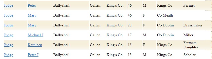
During this time Ballysheil had eight buildings all of private dwellings. With 7 occupied with families between 3-9 members in each. These houses where of 3rd and 2nd class. Example of a household can be seen below.
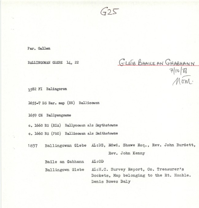
Next we come along the line to Ballingowan Glebe. Situated in the Electoral Division of Cloghan, in Civil Parish of Gallen, in the Barony of Garrycastle, in the County of Offaly
The Irish name for Ballingowan Glebe is Gléib Bhaile an Ghabhann meaning land of the blacksmith.


Along this way you will find old good storage sheds and store. Trade on the canal had established a market infrastructure and with that storage sheds could be found along the banks of the canals. These sheds where used for the storing of corn, turf, flour and other products that were transported along the line all the way to Dublin.
| Townland | Area | Pop in 1841 | Pop in 1851 | No. of Houses in 1841 | No. of Houses in 1851 | Pop in 1871 | Pop in 1911 | No. of Houses in 1871 | No. of Houses in 1911 |
| Ballingowan Glebe | 216 | 85 | 29 | 14 | 6 | 30 | 42 | 5 | 6 |

Ballingowan Glebe Census Ireland 1911. Image Source: https://www.census.nationalarchives.ie/
In 1911 Ballingowan Glebe had eight buildings, all private dwellings. With six occupied with families between 3-9 members in each. These houses were of 2nd class category. Examples of some of the occupations at the time in a household can be seen below. Boat men feature quite a bit on census night in the west Offaly townlands. and often with a Kildare background.

As you walk along the line you will also come to the picturesque Belmont bridge and double lock number 33. It is a lovely spot to stop and taken in the scenery.

Ballyloughan is in the Electoral Division of Cloghan, in Civil Parish of Gallen, in the Barony of Garrycastle, in the County of Offaly
The Irish name for Ballyloughan is Baile an Locháin meaning land of the small lake.

The landscape along this area of the canal line, provides a unique eco system during day time and night time, As the sun begins to go down, a number of different species start to appear along the banks. Water bats are a common sight above the bank, and they are fascinating creatures, with a large number of them found in Ireland. Nine different species in fact. Water bats, also known as Daubenton Bats and can be usually found flying above the water catching large insects. They make their homes in the trees above, always in groups. So next time you’re out for late evening stroll, don’t forget to look up.
One food source for water bats are dragonflies, examples can be seen above of the Four-spotted Chaser (top) and the Brown Hawkers (Bottom). The chaser can be found closer to bog areas and pools, where the Brown Hawkers one of the largest of Dragonflies to be found along the line usually hovering over the water’s edge, unlike other insects of its kind, it is not shy and will defend their territories and self if threatened[3].

Ballyloughan had five buildings all of private dwellings during the 1911 census. With all occupied with families in each. These houses where of 2nd and 3rd class. Example of some of the occupations at the time in a household can be seen below.


Clonony More/ Clonony Beg
Clonony More in the Civil Parish of Gallen. It is in the territory of Delbhna Eathra and was in the territory of Mac Coghlan. Cloghan Village lies in the centre of the Parish, and is a great spot along the way to grab a coffee or something stronger. The parish has an extensive area of bogland.
This Parish has significant archaeological remains, including the Ecclesiastical sites, these sites include Monastic and sites of medieval churches as well as some graveyards[4]. You will find a number of these sites located around the townlands that are under this Parish, It is the highest concentration of ecclesiastical sites.
Clonony More is in the Electoral Division of Shannonharbour, in the Barony of Garrycastle, in the County of Offaly. The Irish name for Clonony More is Cluain Damhna Mór meaning Big Field of the Ox.
As we come into Clonony More, we come to L’Estrange Bridge, which we covered briefly earlier. On your walk you will notice the ruins of an old Inn and large gates where military barracks use to stand, now demolished. The greatest of the Shannon defences was at Shannonbridge. The canon mounted at Shannonbridge was capable of protecting its line from a mile away. Other features included the barracks at the Shannonbridge Fortress, The Shannon Bridge fortress is unique in Ireland and also in Britain.
One of many that were constructed in the early 19th century, a few miles along the same walking path you come to Clonony Castle, it is now a three-storey tower house, which has had 19th century additions . We have an earlier blog on this castle (see it at http://www.Offalyhistory.com). Dating back to 1591, named Clauain Damhna. During a war in the late 15th century, it was named after Cluain Nona[5]. You will find a grave stones here that havethe name of some of the Boleyn family. it is said that they were unearthed by workers during collecting stones form the construction of the bank of earth in the mid-nineteenth century.
| Townland | Area | Popin 1841 | Pop in 1851 | No. of Houses in 1841 | No. of Houses in 1851 | Pop in 1871 | Popin 1911 | No. of Houses in 1871 | No. of Houses in 1911 |
| Clonony More | 732 | 107 | 253 | 22 | 59 | 166 | 104 | 36 | 27 |

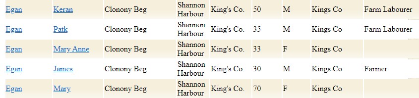
In 1911, Clonony More had a population of 104 and 27 houses recorded in the census, during this period the household returns and ancillary, shows us that there were 27 buildings all of Private Dwelling, with all inhabited, of 2nd class and the other 3rd. Here is an example of families that occupied these buildings are as followed:

In 1798 the Grand Canal had been built as far as Tullamore. After much discussing it was decided to continue on the line along the Brosna Valley rather head towards Athlone. During this three years saw 3000 men working at a great pace, constructing the banks of the canal.
Before the construction of the Grand Canal Line to Shannon Harbour in 1804, it only had a few cottages but with the passing of the canal it became a popular destination and brought with it new life and new buildings started to appear. New agent houses were built along with a hotel at Shannon Harbour (see earlier blogs). Also cottages for employees. Stables and sheds for livestock and store builds along the Shannon harbour line, for products that came off the fly boats during the transport of goods[6].
Next we come up to Griffith Bridge, this brings us to the end of the line and into the Shannon Harbour and also into the Townland of Clonony Beg, You can still see the rope marks in the sides of the bridge, Where horses use to draw the boats along the line. At first canals was used to transport passengers by the use of Horse drawn boats known as Fly boats. They were not very fast and use to take up to 16 hours to reach the end of the line.

| Townland | Area | Pop in 1841 | Popin 1851 | No. of Houses in 1841 | No. of Houses in 1851 | Pop in 1871 | Pop in 1911 | No. of Houses in 1871 | No. of Houses in 1911 |
| Clonony Beg | 693 2 29 | 320 | 283 | 63 | 59 | 149 | 22 | 34 | 5 |

Clonony Beg is in the Electoral Division of Shannonharbour, in Civil Parish of Gallen, in the Barony of Garrycastle, in the County of Offaly. The Irish name for Clonony Beg is Cluain Damhna Beag meaning Small field of the Ox.
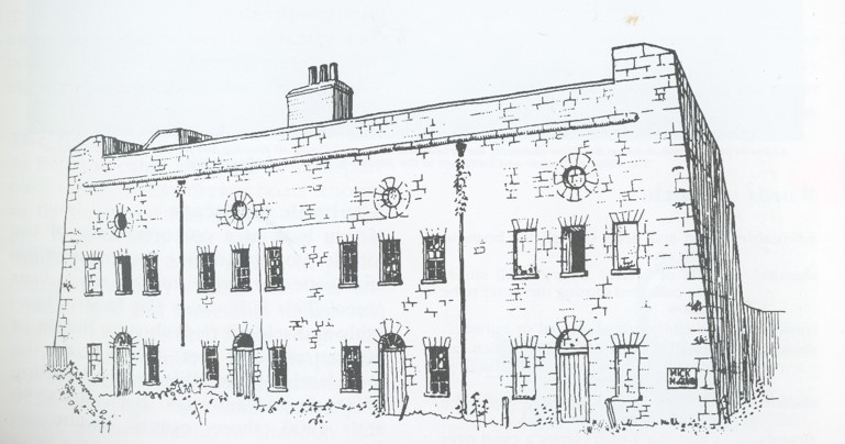
With the construction of the Grand Canal came new business opportunities, The Shannon Harbour Hotel was built in 1806. One of the last buildings to be built by the Grand Canal Company during this time.
Sadly this hotel was not a success by anyone who took over it during the passing down of ownership during its years. Part of the building was closed by 1810 and by 1915 only a few windows and doors where left.

Over its time it was reported as an unsatisfactory venture, in the year 1817 with the trouble along the lines, with attacks and stealing off the trade boats, it was negotiated with the government to lease out hotels along the bank to act as military barracks. During the late 1890s and early 1900s it was uses as apartments, rooms where rented out to locals, due to none payment of rent by many of the tenants, the board decided to render the building uninhabitable to avoid the payment of rates and the remaining tenants were found accommodation in the old barracks[7].


In 1911, Clonony Beg had a one of the largest population of this area recorded in the census, during this period the household returns and ancillary, shows us that there were private dwelling buildings with all inhabited, of 1st, 2nd class and the other 3rd. Here is an example of families that occupied these buildings are as followed:
As we come to the end of the line we come to the last two locks, lock 35 and lock 36. The last foundation for the 36th lock was laid down in 1802.

Over the years the canal have brought with it the expansion of trade, goods could be carried from Dublin to Edenderry to the Shannon Harbour and on to Limerick via the River Shannon. The canal the growth of each Townland, with the Grand Canal help drive and develop the economical industrial during the 17th and 18th century. With the development of the Railway Line, it saw a decline in the use of fly boats, and the new way of transport for goods and passengers was the Railway Line.
Today the canal is used as a popular walking destination. You can see along the canals, a variety of wildlife from rabbits, fox, birds and fish. It is ideal for boat cruising and canoeing, and is one of the major fishing destination during the summer months.
[1] All the way on the Grand Canal. Jo Kerrigan and Richard Mills. Pub The O’Brien Press LTD. 2023. Pp171-175.
[2] Offaly Through Time & It’s Townlands Thomas Lee.Pub Ottait Publishing. 2018.256-258. Pp165.
[3] See “Nature on Irish Canals” Brid Johnson and Marie Dromey, The stationery Office, Pp30-44.
[4] Offaly Through Time & It’s Townlands Thomas Lee.Pub Ottait Publishing. 2018.256-258. Pp97-163.
[5] Offaly Through Time & It’s Townlands Thomas Lee.Pub Ottait Publishing. 2018.256-258. Pp97-165.
[6] Looking around Aspects of the local environment. James Scully. Pub Birr-Banagher I.N.T.O. P35.
[7] The Grand Canal of Ireland. Ruth Delany. Pub:The Littleput Press. 1995. PP121-142
