The Civil Parish of Geashill is the largest Parish in Offaly, and contains 74 townlands. As well as fine fields and bog land – dark, shale and lime mudstone, are just some of the materials you will find in its bedrocks.
The Parish is part of the ancient territory of “Ui Failghe of the O’Connor chiefs”. It contains some of the oldest remains of castles and is rich in history. From ancient sites such as Enclosures and Ringforts. Sadly many of them have been lost due to nature elements and neglect. It contains the town land of Cappyroe which borders the Grand Canal line, it is the 293rd largest townland in Co. Offaly and in Irish is Ceapach Aodha Rua, translation meaning Plot of Land[2].
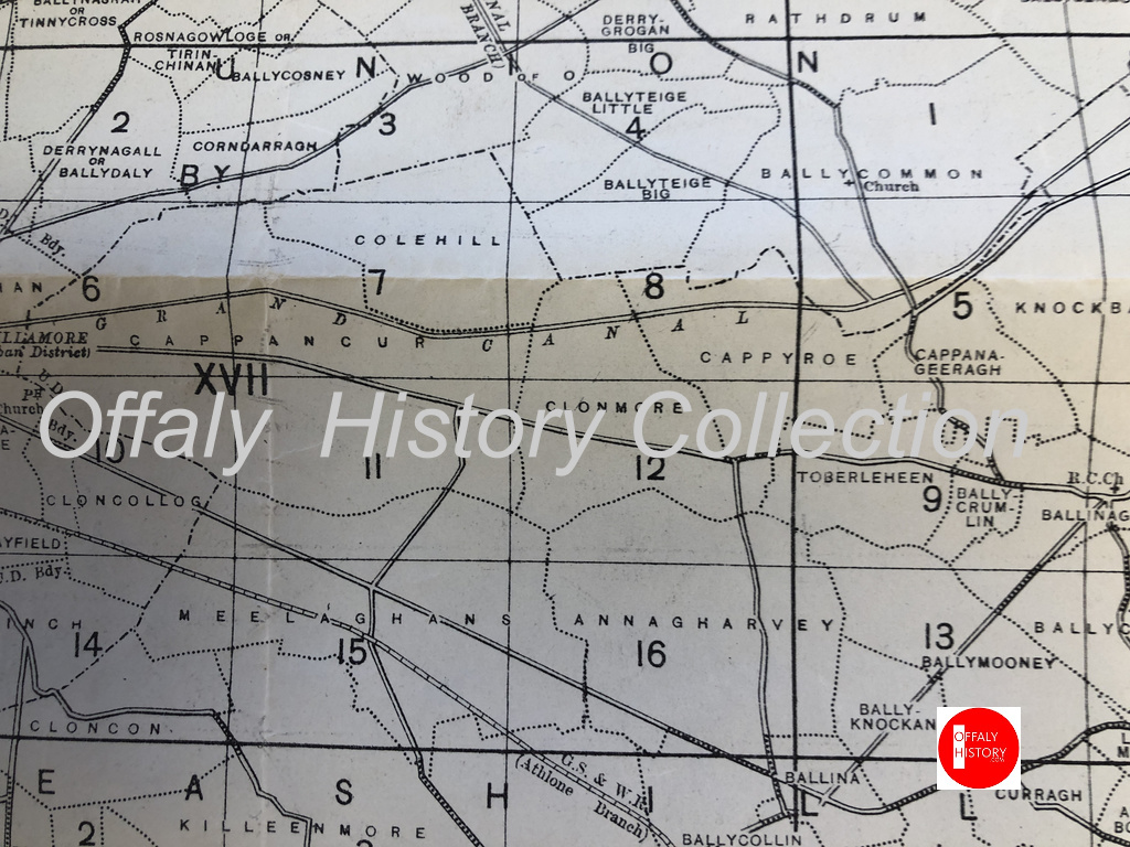
Map of the townlands from Ballycommon to Tullamore. There are over 1,000 townlands in Offaly. See townlands.ie for more.Your walk along the canal from Ballycommon will see you visit Cappyroe, Clonmore and Cappancur
In 1911 Cappyroe had one of the lowest concentration of houses in the area, during this period the household returns and ancillary, shows us that the population decreased from 106 in 1841 to 21 in 1911. There were 6 houses on record, all of all of Private Dwelling, with all inhabited, with classes of houses between 1st and 2nd . Age of occupiers ranging from 1-80. Here are the families that occupied these buildings during this time:
As we make our way along the line, we come to lock 22nd, which was previously mentioned in the last series of “East to West”. The 23rd Lock is followed close behind. A smooth and clear pathway can be found, making it easy to walk or cycle along the way. Coming up we see the 24th Lock. This lock is located near the former Celtic Canal Cruisers. We are preparing an article on this canal attraction, 1974-2004.
(08. Celtic Canal Cruisers / Image Source/ Offaly History). We are preparing a blog on this important cruise line. Can you help with material?
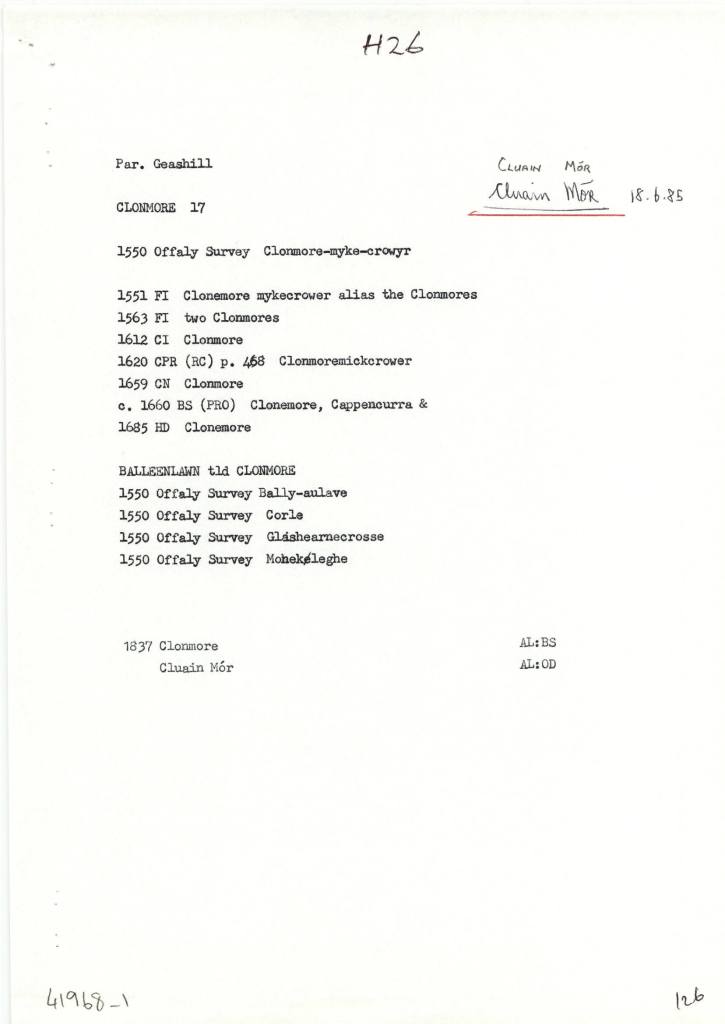
Clonmore (Cappancur), in the Civil Parish of Geashill, in the Barony of Geashill, in the County of Offaly. The Irish name for Clonmore is Cluain Mór meaning Great Field.
Clonmore is the site of a few known churches the Balleenlawn Church that stood until the early 19th century. Its Foundation, was discovered in 1942. It also contained an old graveyard that is still intact today[3].
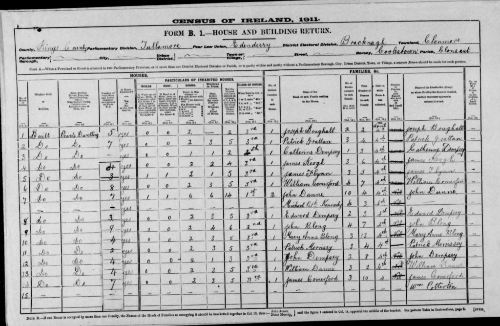
In 1911 Clonmore had 26 houses in the area, during this period the household returns and ancillary, shows us that the population decreased from 220 in 1841 to 101 in 1911. There was 26 houses show on record all of all of Private Dwelling, with all inhabited, with classes of houses between 1st, 2nd and 3rd. Age ranging from 1-80. Here are some of the families that occupied these buildings during this time:
(15.Coachman, source Travel and Transport in Ireland, Edited by Kevin B.Nowlan)
With the construction of the Grand Canal it provided a better connection to reach different townlands around the country. With many place still not connected by waterway, the coach services provided that connect for passengers to reach their final destinations.
As we make our way out of the Geashill Civil Parish, we reach the 25th Lock and Just at Digby Bridge, here we can see just the spire of Tullamore’s Catholic church. Close by is the 26th lock, the barony bridge with its passage under the canal and on to Tullamore. More on Wednesday.
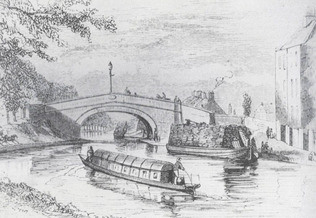
Flyboats on the canal in the 1830s, similar to the later design of the Celtic Cruisers fleet of the 1970s
[1] See “Safe Harbour, The Grand Canal at Edenderry” Mairead Evans & Therese Abbott” Topic Newsppapers Ltd, P22-23
[2] Offaly thought Time & Its Townlands. Thomas Lee. Pub: Ottait Publishing p173
[3] Offaly thought Time & Its Townlands. Thomas Lee. Pub: Ottait Publishing p173
As we make our way along we start to make the journey to Ballycommon, we come to Townparks townland, in the Electoral Division of Daingean, in Civil Parish of Killaderry, in the Barony of Lower Philipstown, in the County of Offaly. The Irish name for Townparks is Páirceanna an Bhaile. Townparks townland in Daingean has the site of Fort Governor which was built in 1547 on the site of an O’Connor Castle stronghold.
along this line we come to one of the gems along this way, the Bord Na Mona lifting Bridge, It’s an interesting spot and a great location to get the camera out. From the late 18th century, the canal was used as a way to transport turf from different cutting points along the line. As trading long the canal was increasing rapidly and was even more encouraged when charges were abandoned, the one that was always a difficult trade to control was the “Turf”[1].
03. The half-inch of c. 1910 from Philipstown to Ballycommon and Cappancur Offaly History Centre. Showing also the Kilbeggan Line of the 1830s.
A few incidents along the line was reported, before the construction of the Circular line, including situations where turf traders, held up and demanded change to the dispatching and the price of turf. After a standoff with an angry crowd, that were armed with swords and guns. The canal company, compromised with the people and ordered that all boats display a clear sign with the price of their turf.
During this time quays were used along the canal to unload turf and an inspector was appointed to see the overall control of the Turf trade. By the early 19th century, a steady flow of boats travelled up and down the line, with up to 33,000 tons every year arriving for dispatch. G- Boats were the main boat used when transporting product and with a fixed toll now applied to all traders, this encouraged the use of greater loads.
In March 1914 the Foresters Hall played host to meeting called organise the Irish Volunteers in the district. Following the outbreak of the Great War and the resulting divisions within nationalism, the Tullamore Corps of the National Volunteers gathered at the Foresters Hall to reaffirm their support for John Redmond. The Foresters branch secretary James Hayes joined the 5th Lancers in early 1916.
In December 1915, the Ideal Cinema was the venue for a screening of ‘Joan of Arc’ in aid of the Red Cross. Two months later, the Urban Council arranged a reception at the hall to present an address to captain Edward Sherlock after the Rahan man was awarded a military cross for his actions on the Western Front. As late as February 1918, the hall hosted a lecture by Henry Hanna KC on ‘The Pals (7th Dublin Fusiliers) at Suvla Bay’ in aid of the Leinster Regiments Prisoner of War fund. Nevertheless, by then the Foresters and their hall had come to be associated extreme nationalism in the mind of some within the police.
A programme for the Foresters in 1916
At a show the hall in on St Patricks Day 1917, a twelve-year-old girl Lena McGinley dressed in a ‘Green, White and Yellow’ costume performed a poem dealing with the 1916 Rising entitled ‘Vengeance’. As a result, sergeant Henry Cronin had the concert organisers James O’ Connor and Edward O’Carroll charged under the Defence of the Realm Act (DORA) for ‘attempting to cause disaffection among the civilian population ‘. On their conviction O’Connor and O’Carroll refused to be bound to peace and were instead imprisoned in Mountjoy.
The weather was bad when Joseph Hutchinson arrived in Tullamore. For 22 years Hutchinson had dedicated himself to the Irish National Foresters and as a result a small mutual aid society founded by 18 men in Dublin, had spread across the globe and recruited over 20,000 members in Ireland. On Sunday 9 April 1899, Hutchinson had come to the midlands to recruit some more members and establish the first INF branch in King’s County. His visit that day would have profound repercussions for Tullamore, but it had its roots in the north of England.
This article looks at the north Offaly towns featured in Major (later general) Vallancey’s report carried out in 1771 and designed to support the construction of the new Grand Canal line to Tullamore and the Shannon. Vallancey was then a young engineer, employed to report to the Commissioners of Inland Navigation and his findings were published in, AReport on the Grand Canal or Southern Line (Dublin 1771).[1] This report is useful as a window on some of the north King’s County (hereafter generally referred to as Offaly) towns and villages.[2]
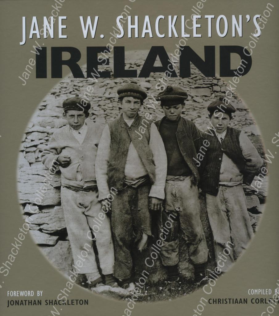
Jane W. Shackleton’s Ireland compiled by Christiaan Corlett (Cork, 2012) is an attractive large format publication was issued by Collins Press and consists of 180 well produced photographs by Jane Shackleton. These pictures are important for the photographic record in County Offaly and mostly date to 1894.
Not surprisingly there are many pictures of mills in this book and there are about ten pictures of Offaly interest. Jane Shackleton started taking pictures in the 1880s and made several tours on the Shannon and along the Grand Canal and Barrow lines. These waterways photographs contribute greatly to the history of the canals and the great mills which were associated with river locations. Many of these were in fact owned by Quaker industrialists. Like other interested women of the period Jane Shackleton was a member of the Royal Society of Antiquaries (RSAI) and took photographs of some of their tours including that of June 1904 around Ireland. Midleton Biddulph, the amateur photographer and retired army officer of Rathrobin near Tullamore was also on this trip and some of his pictures survive and have been published as Rathrobin and the two Irelands; the photographs of Middleton Westenra Biddulph, 1900–1920 (Tullamore, 2021). Corlett informs us that the Shackleton collection consists of 1,000 lantern slides and 44 albums containing several thousand prints, mostly of Irish subjects. This writer had the pleasure of seeing some of the Grand Canal and the turf works at Pollagh back in the early 1970s with Richard Shackleton and Jonathan Shackleton.
Part two of this presentation looks at the Charleville and Macartney aqueducts west of Tullamore and the Silver River aqueduct halfway between Ballycommon and Kilbeggan.
THE CHARLEVILLE AQUEDUCT
The Clodiagh River rises in Knockachoora Mountain in Sliabh Bloom and flows swiftly through Clonaslee and on under Gorteen, Clonad and Mucklagh bridges into Charleville Demesne before passing under the Charleville Aqueduct, just before its confluence with the Tullamore River at Kilgortin in Rahan. Less than half a mile upstream on the canal stands the Huband Aqueduct overlooked by the imposing Ballycowan Castle.
The Charleville Aqueduct is called after Charles William Bury who had become Viscount Charleville in December 1800 and it was as such, he was recorded in the lists of attendees of the Court of Directors of the Grand Canal Company during the years the canal was being constructed from Tullamore to Shannon Harbour, 1801-04.
Image 1.excerpt from the minutes
An excerpt from the minutes of a meeting of the canal company held 24th February 1801 where Lord Charleville’s request for the use of one of the company’s boats for the purpose of conveying Lady Charleville to town was accommodated. The memo further states that his wife was in a precarious state of health, most likely an allusion to her being in the advanced stages of pregnancy as her son Charles William Bury was born nine weeks later, on 29th April 1801. (Courtesy of National Archives of Ireland, Dublin)
Image 2. Charles William Bury, 2nd earl
Charles William Bury, 2nd Earl of Charleville, born late April 1801, seated in red cloak before a curtain, portrait by Henry Pierce Bone, 1835.
C. J. Woods’s entry for the first earl of Charleville, (1764-1835), in Dictionary of Irish Biography, R. I. A., (2009), gives a concise résumé of his adult life:
Bury was MP for Kilmallock in 1789–90 and 1791–7, becoming Baron Tullamore on 26 November 1797, Viscount Charleville on 29 December 1800, and 1st earl of Charleville (of the second creation) on 16 February 1806. He was an Irish representative peer from 1801 until his death. With Johnston he designed and built a Gothic castle on his demesne, Charleville Forest, 3 km south-west of Tullamore. Begun by November 1800, it was completed in 1808, to which a terrace, lawns, artificial lake, grotto, and 1,500 acres of woodland were added. Elected a fellow of the Royal Society in 1803 and a fellow of the Society of Arts in 1814, Charleville had ‘wide intellectual interests which never came to fruition’. The earl of Charleville died 31 October 1835 in his lodgings at Dover and was buried at Charleville.
Fred Hammond’s great survey of the bridges in Offaly (2005) gives the following description of the building:
Triple-span masonry bridge carries Grand Canal over Clodiagh River. Abutments, piers and cutwaters are of dressed limestone blocks, regularly laid. The cutwaters are of triangular profile and rise to arch spring level at both ends of the piers. The arches are of segmental profile and each spans 3.07m; their voussoirs are of finely dressed stone. The soffits are very slightly dipped towards their centres to accommodate the bed of the canal. Dressed string course over arch crowns. Parapets are of random rubble, coped with dressed masonry blocks. The parapets are spaced at 10.08m and terminate in out-projecting dressed stone piers. The east end of the south parapet has been rebuilt. The canal narrows to 4.50m, with tow paths either side. The sides are stone lined at this point and there are timber stop slots at the east end of the aqueduct.
Hammond considered the edifice worthy of regional heritage importance.
THE MACARTNEY AQUEDUCT
Image 3.Detail of William Ashford’s painting
Detail of William Ashford’s painting of the crowded scenes at the opening of the Ringsend Docks, Dublin, 23 April 1796, showing Lord Camden, the Lord Lieutenant of Ireland, conferring a knighthood on Mr. John Macartney with the Westmoreland, Buckingham and Camden Locks in the background. Macartney can be seen in a genuflected position on the right-hand quay wall beneath a billowing British naval flag. (Courtesy of the National Gallery of Ireland)
This is the western-most aqueduct in Offaly straddling the townlands of Falsk and Derrycarney, south of Ferbane. The structure is named after Sir John Macartney, one of the more influential directors of the Grand Canal Company. As alluded to above he was knighted by the Lord Lieutenant at the opening of the Grand Canal Docks in 1796, “in consequence of his energetic exertions in the promotion of the inland navigation of Ireland.” Like Huband’s Aqueduct at Ballycowan, it has two commemorative plaques dating it to 1803.
Image 4. Commemorative plaque dated 1803
Commemorative plaque dated 1803 on the south parapet wall of the Macartney Aqueduct.
Fred Hammond’s appraisal of the building says it all:
This is the largest aqueduct on the Grand Canal in Co. Offaly and second only to the Leinster Aqueduct (Co. Kildare) in size on this canal. It is of high-quality construction and has been sympathetically refurbished. It is of historical interest due to attested date and link with Grand Canal Co. Also, a substantial landscape feature hereabouts. Of national heritage significance, meriting inclusion in Record of Protected Structures.
Image 5. A delightful drawing by Israel Rhodes
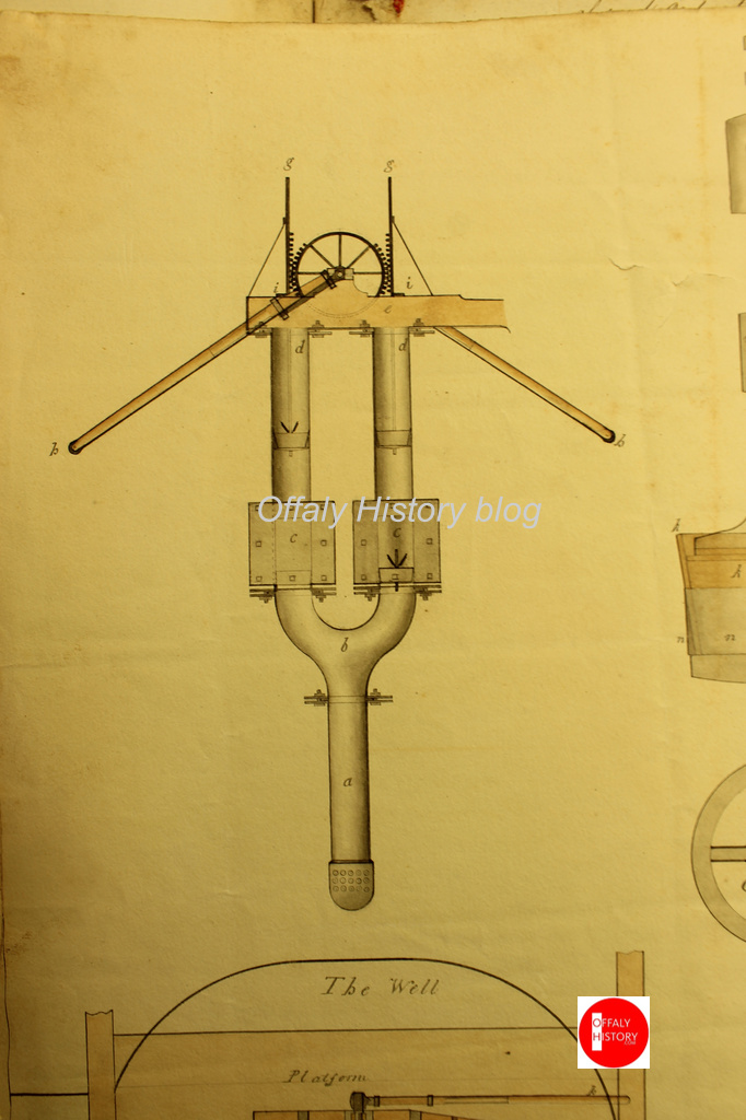
A delightful drawing by Israel Rhodes, dated to March 1802, showing details of the steam-powered pump that was used during the construction of the Macartney Aqueduct over the Silver River. This is from the minute books of the Grand Canal Company where such visual representations are very rare. The depiction is signed by Rhodes as engineer and by Arthur Chichester Macartney, then an influential director of the canal company. (Courtesy of National Archives of Ireland, Dublin)
The aqueduct crosses the fast-flowing Silver River after it has meandered over twenty-miles from the slopes of Wolftrap Mountain high up in Sliabh Bloom The river’s course takes it through Cadamstown, Ballyboy, Kilcormac and Lumcloon before joining with the Brosna half a mile downstream of the aqueduct.
Image 6. Map by John Longfield c.1810
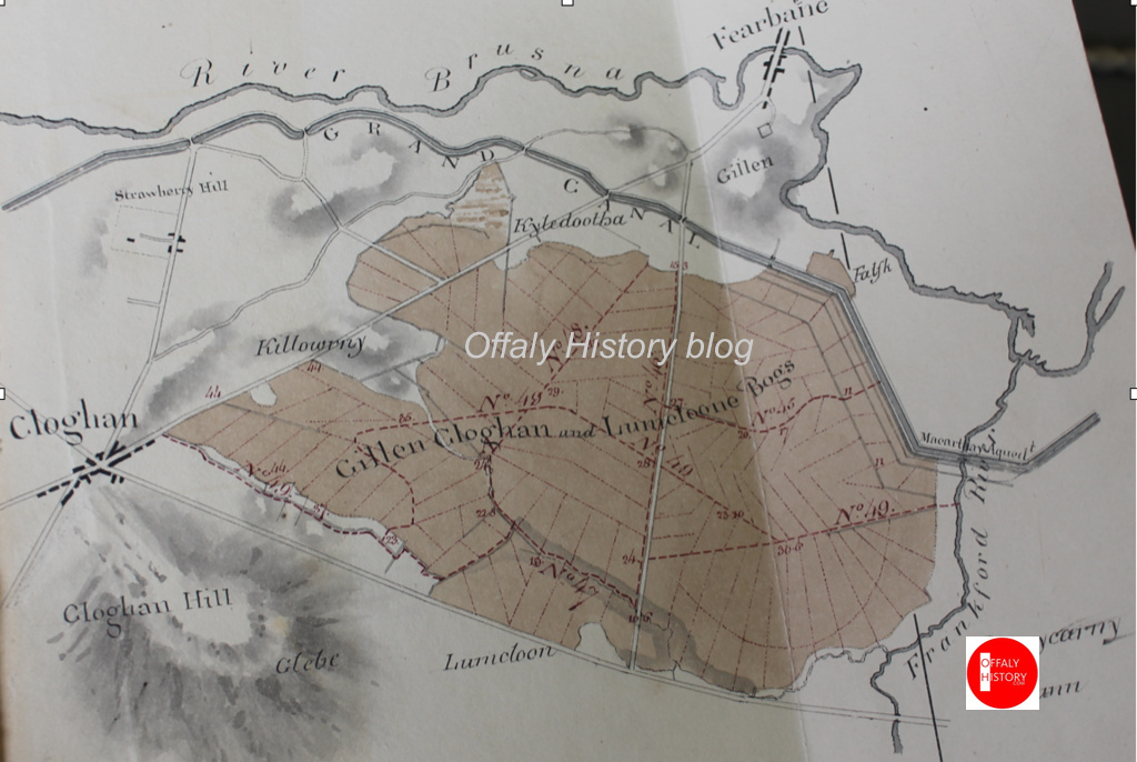
Map by John Longfield c.1810 showing the Grand Canal turning sharply to the north-west just downstream of the Macartney Aqueduct and thus avoiding the Gallen, Cloghan and Lumcloon complex of bogs before meandering (almost) from Gallen to Belmont, always in close proximity to the River Brosna. The Silver River is depicted as the Frankford River in deference to the old name for Kilcormac, the last town it passes through before its confluence with the Brosna. (Courtesy of The National Library of Ireland)
SILVER RIVER AQUEDUCT ON THE KILBEGGAN BRANCH
To avoid confusion with the other Silver River crossed by the Macartney Aqueduct, this aqueduct straddles the Silver River which separates the counties of Offaly and Westmeath between the townlands of Bracklin Little and Lowertown. The river rises upstream of New Mill Bridge, in Rahugh, in Westmeath. In Offaly it flows via Derrygolan, Acantha, Gormagh, Ballyduff, Aharney, Coleraine, Coolnahely and Aghananagh before joining the Clodiagh at Aghadonagh, in Rahan. The 1838 six-inch map shows five mills on this relatively short river. The earliest of these mills is probably that at Ballynasrah or Tinnycross as it is shown on John Gwin’s map of the Barony of Ballycowan which was drawn c.1625, almost four hundred years ago.
Image 7. Detail of John Gwin’s map showing Silver River
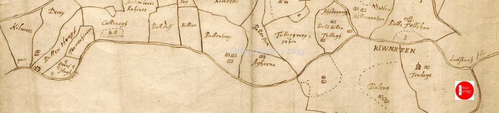
Detail of John Gwin’s map of the barony of Ballycowan which shows the Silver River flowing from Ballynasrah in the bottom left-hand corner to its confluence the Clodiagh at Aghadonagh on the right- hand side, passing Ballyduff, Aharney and Tullymorerahan. The mill is indicated by a mill-wheel symbol. The map is part of a set of twenty-eight important maps of various parts of Offaly drawn four hundred years ago in the Mathew De Renzy papers in the National Archives in London.
KILBEGGAN BRANCH
As early as 1806 the Grand Canal Company’s engineer John Killaly had prepared a detailed map for a proposed branch from Ballycommon on the main canal to Kilbeggan. This line was closely adhered to when work finally begun twenty-four years later in 1830. An application for funding was made in 1825 and despite strenuous objections from the Royal Canal Company a loan was approved in 1828. In March 1829 Killaly had completed the plans and specifications for the line. A month later William Dargan’s proposal to build the line for £12,850 was accepted.
Image 8 William Dargan
William Dargan, (1799-1867)
From the outset work was slow due to continuous wrangling between the contactor and the company. Dargan had taken his own levels, but the canal company insisted he use those of Killaly. Even when progress was made recurring problems with staunching the huge embankments at Bracklin Little and Lowertown delayed construction. Allied to this was the major distraction of Dargan’s involvement with the building of Ireland’s first railway line.
Image 9. Bracklin Little and Lowertown townlands on the1912
Bracklin Little and Lowertown townlands on the1912 Ordnance Survey six-inch map, showing the meandering Silver River and the dense hachuring between Lowertown and Murphy’s bridges. This represents the steep slopes of the embankments which carry the aqueduct high above the surrounding landscape. Note the overflow at south end of the aqueduct. This was to prevent the level of the canal rising to a height where it would overflow the banks and lead to a major breach. Just like at the Blundell Aqueduct there were twenty-six miles of canal without a lock which would have poured out at this point if a burst occurred, leading to much destruction and a long-term closure of the navigation.
Dargan’s chief biographer Fergus Mulligan describes this episode in Dargan’s life in the Royal Irish Academy’s Dictionary of Irish Biography:
Ireland’s first railway line, the Dublin & Kingstown, opened in 1834 and Dargan was fortunate to win the contract to build it against six competitors. Working under another Telford pupil, Charles Vignoles (qv), as engineer, Dargan began work near Salthill in April 1833, and although he was six months late finishing the line (which opened on 17 December 1834) the penalty clauses in his detailed contract were not enforced. The successful completion of this line gave Dargan a springboard to winning a substantial share of Irish railway construction contracts on offer in the 1840s and 1850s.
Again, we are greatly indebted to Fred Hammond’s monumental survey of all 407 bridges in Offaly in 2005 for a detailed description of this aqueduct:
A tall arched masonry bridge carries the disused Kilbeggan Branch of the Grand Canal over the Silver River at the county boundary. The abutments are of dressed limestone blocks, regularly laid and with finely dressed quoins. The arch is of semi-circular profile, with finely dressed radial voussoirs and dressed stone soffit blocks; it spans 3.59m. The arch is embellished with finely dressed string courses around the tops of the quoins and across the crown. Over the top of the upper string course are four regular courses of dressed stone blocks. They are surmounted by a slightly inset random rubble parapet. The sloping wing walls are detailed as the abutments and are coped with stone flags.
Patrick Lynch and John Vaizey in their history of Guinness’s brewery in the Irish economy to 1876 observed that in England the canals followed trade while in Ireland it was hoped that trade would follow the canals. It was a hope that was only partially fulfilled as outside of Dublin the new canals served few areas of commercial or industrial importance.[1] The observation was following in the line of Arthur Young in the 1770s who had advised ‘to have something to carry before you seek the means of carriage’.[2] Yet the record of the carriage of goods on the canal was satisfactory with 500 million ton miles carried in 1800 and double that by the 1830s.[3] The Grand Canal was especially beneficial to north Offaly for the transport of stone, brick, turf, barley, malt and whiskey. All bulky goods suited to water transport. The emerging firm of Guinness also found the inland water transport system helpful to sales and market penetration. The slow movement of Guinness beer by waterway was good for product quality on arrival.
The view is about 1840 and the book 1960. There is a copy at Offaly History Centre Library
Work on the Grand Canal started in 1756 and by 1779 the first stretch of water from James’s Street to Robertstown was completed. Over the next twenty years the canal was extended to Tullamore (1798) and Shannon Harbour (1804). The six-year delay at Tullamore while resolving issues with the direction of the ‘Brosna Line’ at Tullamore facilitated the establishment of a canal hotel, stores and a harbour.
We looked a few days ago at Charles Lever’s description of Shannon Harbour through the eyes of Jack Hinton (1843) and which he commenced writing in the winter of 1841. Another visitor to Banagher was the celebrated novelist, Anthony Trollope. Material has already been published on Offaly History blog on Trollope’s connection with Banagher where he arrived in September 1841 to take up employment with the Post Office. In his Kellys and the O’Kellys (London, 1848), Trollope sends Martin Kelly from Portobello, Dublin to Ballinasloe. His description of the journey is as derogatory as Lever’s and may well be autobiographical as Trollope travelled on the canal as a young man to take up that first post at Banagher.
The line from Tullamore to the Shannon is known as the Brosna route. Last week we looked at it from the terminus at Shannon Harbour and followed Donal Boland’s well illustrated trip from the Shannon to Tullamore. The canal had reached Daingean in 1797 and Tullamore in 1798. It was then the terminus for six years with trade opened to Shannon Harbour in 1804 and fully in 1805. During that period the directors of the Grand Canal Company had considered three options for completing the canal to the Shannon:
1. To lock down into the River Brosna and continue as a river navigation.
2. To construct a canal alongside the Brosna.
3. To continue the canal on the same level to the south, with the possibility of an extension to Birr and the lock down steeply into the Shannon at Banagher.
The commencement of the Brosna line at Tullamore was east of the Kilbeggan bridgeand close to the first canal warehouse on Bury Quay close by this footbridge of the 1930s to 2013.(more…)













 offalyhistoryblog