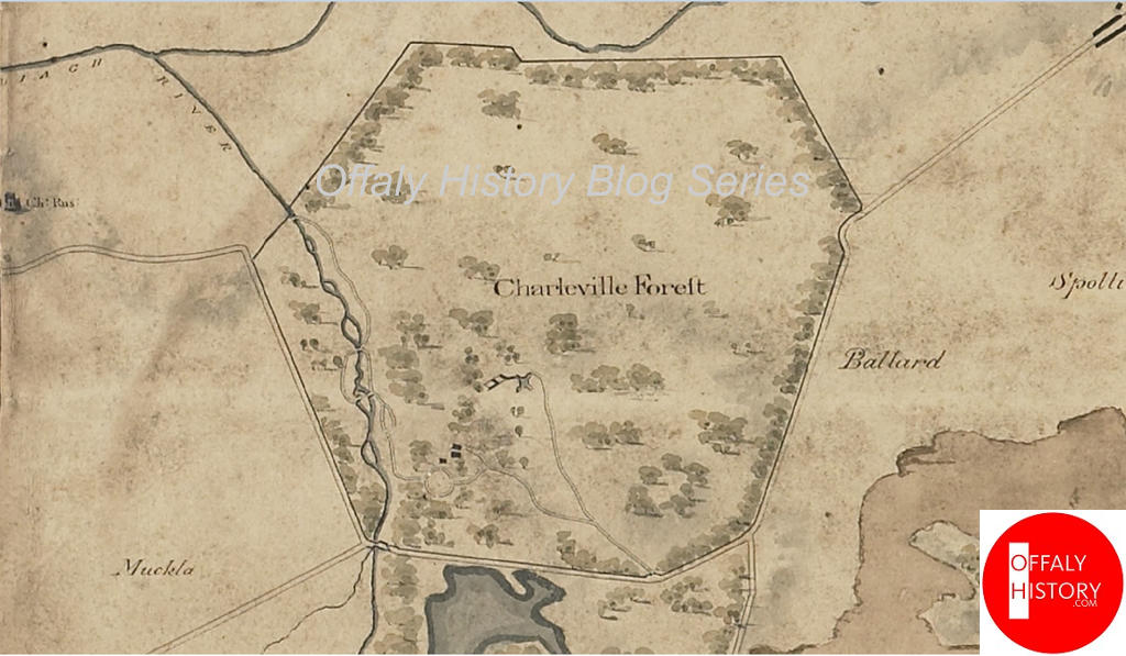
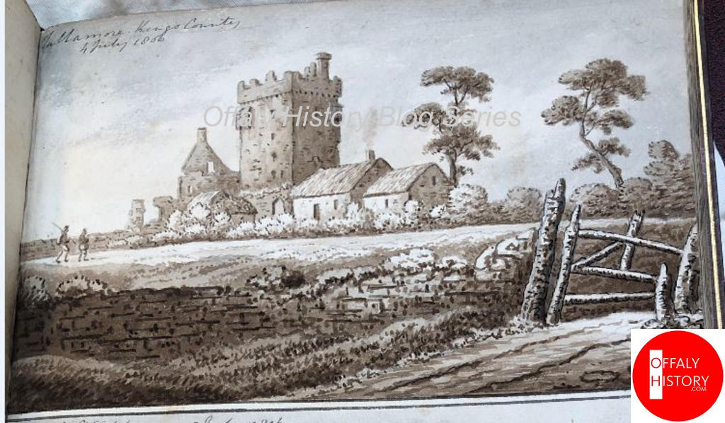
Sir Richard Colt Hoare’s account of his visit to Ireland in 1806 is of interest to us in County Offaly for his comments on the progress of building at Charleville and the two surviving drawings of the Srah and Charleville castles in a book of drawings of Colt Hoare’s in the RIA. These drawings are important for the catalogue of topographical drawings and paintings of King’s County/Offaly interest and hence their inclusion here. Srah/Sragh Castle can be described as Tullamore’s oldest surviving house and was erected in 1588. The fortifed house has attracted the interest of antiquarians since the 1800s. The Colt Hoare drawings are among the earliest and certainly that is so for Tullamore where paintings and drawings of topographical features are scarce until the contemporary artists began to fill the void.
The RIA in a blog (probably by the late Peter Harbison who was working on a book of Colt Hoare’s drawings before his death) commented:
Sir Richard Colt Hoare (1758–1838) was an English antiquary, archaeologist and traveller, who inherited a large estate centred on Stourhead in Wiltshire. He was independently wealthy, and could afford the luxury of travel. His Recollections abroad, published at Bath in the years 1815–1818, were based on his tours of continental Europe between 1785 and 1791. He visited Ireland in 1806.
In later life he developed a particular interest in the archaeology of his own area, and published the findings of his local archaeological excavations in two volumes on The ancient history of Wiltshire (1812; 1821; reprinted 1975). He assembled a large private library on the history and topography of Britain and Ireland; the printed catalogue of his library ran to 361 pages.
Sir Richard Colt Hoare visited Ireland in 1806 and created an album of pencil and watercolour sketches of castles and monastic buildings. Royal Irish Academy MS 3 C 40 is a bound album entitled ‘Views of Ireland’ and comprises 104 pencil and watercolour sketches illustrating his extensive tour in Ulster, Munster, and Leinster. He also wrote at length about his journey, and this was published in the following year: Journal of a tour in Ireland in 1806 (London & Dublin, 1807). The 1807 book does not contain illustrations.
In introducing his narrative of his Irish journey, he observed that in contrast to Wales and Scotland, ‘the Island of Hibernia still remains unvisited and unknown’. He lamented the lack of books about Ireland’s history and antiquities, and he prefaced his narrative with an overview of the books that were available to him.
His interest in antiquities was clearly revealed in his visual record of his tour of Ireland preserved in RIA MS 3 C 40. Rather than sketching landscapes, he devoted his attention to depicting castles, monasteries, and occasional round towers.
Harbison published an article in the Irish Arts Review in 2019 (part online) where he commented on Colt Hoare’s work and illustrated the article with the drawing of Srah Castle among others. The drawing is described as Tullamore 4 July 1806. The published account of the tour appeared in 1807 and probably disappointed the Charleville’s who were preparing to open the castle in 1809. It was completed in 1812 in the same year as Edward Wakefield’s unkind remarks about Charleville.
Colt Hoare wrote:
Page 30 From Mitchelstown to Tullamore, Nenagh, Killaloe, Limerick, Adair, Tarbert, Tralee, Ardfert and Killarney.
Friday 4th July. – From Mitchelstown to Mullingar XII miles: road good, country stoney and flat, chiefly pasture. See Martinstown Castle in a field to the left; and the ruins of another fort on the right, with a small lake. See on the left Reynella, the seat of Mr. Reynell, and afterwards on the right Killynan, another seat of the same family. Observe a tumulus on the left. Cookesborough the seat of Mr. Cooke; a line of most miserable hovels, with smoke issuing from a hole in the thatched roof: two lakes on the right.[1] This tract of country bears but a ragged appearance, from the general want of trees, hedge-rows, and the slovenly state of its cultivation. A large fair now holding at Mullingar, which a traveller would wish to avoid as much in Ireland as in Wales. The post-horses met us at the entrance to the town, 31 where the hostler harnessed the riding horse on the off-side, and did not perceive his mistake till asked by us “If that was the custom of his country?”
From Mullingar to Kilbeggan XII miles. Road good, and mostly flat. See crowds of females, and many of them otherwise well drest, flocking barefooted (more Cambrico) to the fair: and near the town a large group performing ablutions in a pond, preparatory to putting on their stockings. A circular earthen work adjoining the road on the right; also a large lake called Lough Ennel in the same direction. Many gentlemen’s seats*[2] decorate its eastern banks, which are well wooded, and more abrupt than those on the opposite 32 side. A church in ruins on the right, cemetery crowded with monumental memorials; another in the same line and in the same state; a lodge placed on the opposite side of the road to the entrance gate; a peculiarity, I am told, very common in Ireland: ornament and cultivation cease; a mere spirit: dreary country returns, lands rather more cultivated with corn; a large bog; cross the River Brusna flowing out of lough Ennel; several mills in a vale on the left; and a ruined castle on the right.
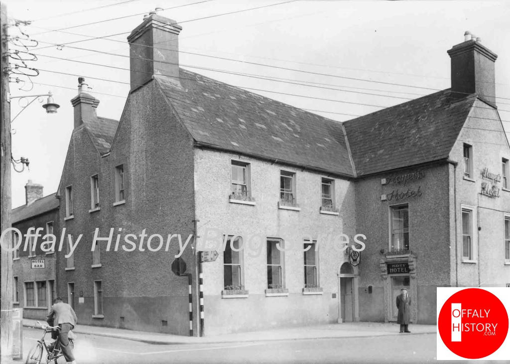
Kilbeggan is a small town situated on the River Brusna. Post horses kept, but none at home. Landlord’s name is Cuffe, who was knighted in a frolic by Lord Townshend during his Lieutenancy; and his wife still prides herself in her titled honours. The inn though kept by a Knight and his Lady, bears but a melancholy appearance.[3] Continued our journey with the same post horses; a raised causeway over a bog, with deep ditches on each side; a narrow ridge of hill; corn fields increase; see distant hills on the right: another bottom and ascent; road becomes worse and wants mending. Leave the County of Westmeath, and enter the King’s County. The face of the country improves on approaching Tullamore, where I found a good Inn and accommodations at Doherty’s, (the Charleville Arms)[4] near the bridge.
33 This town was burnt down a few years ago, but is reviving very rapidly, and bears a busy and flourishing aspect: it is intersected by a canal leading from Dublin to the Port on the Shannon, on which a covered boat, like the coche d’eau in Holland and Flanders, is fitted up for the convenience of travellers. At a short distance from the town, and on the banks of this canal is a small square fort in good preservation.
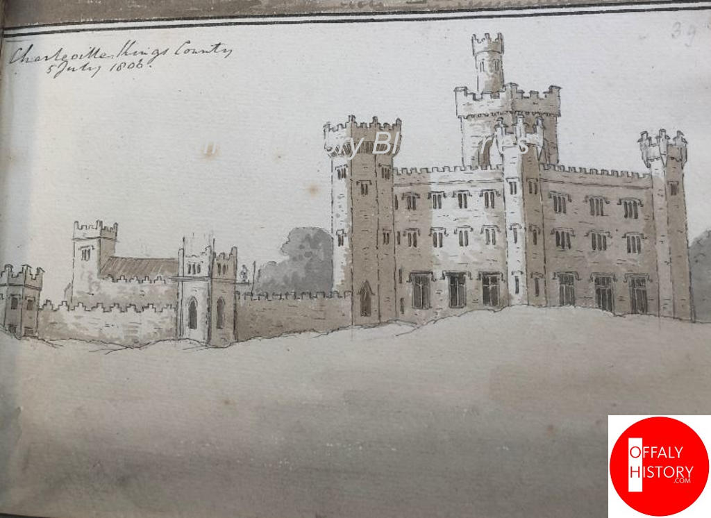
Saturday 5 July. From Tullamore through Frankford, to Birr XIX miles. Two miles from Tullamore is the seat of Lord Charleville adjoining the turnpike road, where a handsome castellated mansion is now erecting under the superintendence of Johnson the architect.[5] The plan of this building aims at accommodating the most prominent features of a baronial castle to the conveniences of a modern habitation: the most objectionable part is the large tower which appears to issue from the centre of the building; and which at an immense height is perforated by four large arches; and thus its massive solidity and grandeur are completely destroyed. The whole is built with fine grey stone, and seems very well executed. The adjoining park is well wooded, but flat. Returning to my carriage, I continued my route; open corn fields; a country ragged and stony. See a gentleman’s seat on 34 the left [Merryfield];[6] a roofless chapel on the right; a long tract of dreary country; road rough in parts; a large extent of bog on the right. Country improves on approaching to Frankford, a small town with an inn, and a scanty supply of post horses. Here I baited mine. There is nothing at this place worthy of the stranger’s attention. The cultivation is good near the town, but it soon ceases. Turf cars busily employed in bringing home food for the winter’s fires. A bog on each side of the road; a gentleman’s seat, and better cultivation occasionally enliven the face of the country; a nursery garden of firs and forest trees on the right: Would that they were more numerous, and that they found customers! Ireland would then regain the sylvan honours it has lost for so many centuries, and no longer present so black and barren an aspect.**[7]
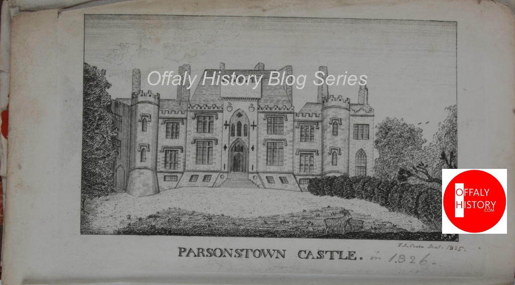
Birr, formerly called Parsonstown, is situated on the River Birr. It is a large, new well-built town with straight streets; the principal of which is terminated by Duke’s Square, so called from a statue of the Duke of Cumberland, by Cheere, erected on a handsome and lofty column. It is placed disadvantageously 35 within a circular inclosure, and moated by a stream of water.[8][9] At the other end of the town is a castellated mansion of the Parsons family, built (as I was informed) after the designs of Johnson the architect. At Birr, is a good inn, (King’s Arms, Dooly) where I snacked***.[10]
Leaving Birr, I shortly entered the county of Tipperary, passing through a village with mills, and a small castle; another ruined fort on the left; corn lands; a castle in ruins on the right; a line of road as straight as if it had been planned by a Roman engineer; an extensive plain, with distant hills; bog; a slight ascent; a large bog on the right; a church rebuilt, with the ruins of the more ancient one, annexed. Corn, pastures, and bog; road rough in parts; a gentleman’s seat on the right; more wood; another seat on the right; the country improves; plain bounded by some high hills.
Nenagh is a large town, regularly built; has the remains of a castle, with a round tower of strong masonry. I found good accommodations at the New Inn, (Fitz-Patrick.) Cattrell’s New Inn has the advantage as to exterior appearance: but some friends of mine, who followed me, complained bitterly of its interior.
36….
[1] [This must have been Robert Cooke, father of Adolphus about whom the DIB entry records: Cooke, Adolphus (1792–1876), eccentric, was born in Cookesborough near Mullingar, Co. Westmeath, illegitimate son of Robert Cooke, landowner, and an unnamed servant. Adolphus’s mother was sent away, and he was raised by a nurse, Mary Kelly, in a two-room thatched cottage, forbidden to visit his father’s house. Educated in England, he joined the army, serving in Spain, Portugal, and South Africa. Robert Cooke died in 1835; as his two legitimate sons had predeceased him, the estate was left to Adolphus. As a landlord, he was a military disciplinarian. He drilled his labourers as if they were soldiers and dismissed them if they lost any of the tools he had given them. He hired unusual staff, including a large, slow-witted man called Tom Cruise.] You can read online at DIB and it gets better,
[2] * Mr. Rochfort’s, Lord Belvedere’s, &c. In speaking of the latter, Mr. Young in his admirable Tour through Ireland, says, “The house is perched on the crown of a beautiful little hill, half surrounded with others, variegated and melting into one another. It is a most singular place; spreads to the eye a beautiful lawn of undulating ground, margined with wood; single trees scattered in some places, and clumps in others; the effect so pleasing, that were there nothing further, the place would be beautiful; but the rest of the canvas is admirably filled. Lough Ennel, many miles in length, and two or three broad, flows beneath the windows. It is spotted with islets; a promontory of rock, fringed with trees, starts into it, and the whole is bounded by distant hills. Greater and more magnificent scenes are often met with, but no where a more beautiful or a more singular one.” [all on page 31]
[3] The Volunteer Inn – the story is well known
[4] Later Hayes’ Hotel and now the location of Boots Pharmacy.
[5] Francis Johnston, architect
[6] Proably a reference to the lost house of Merryfield and the Croftons – see Taylor and Skinner.
[7] ** The numerous and large pieces of timber found in the bogs throughout Ireland, prove how well wooded the country must have been in ancient times.
[8] The column erected in 1747 and still in Birr but less the Duke removed as it was leaning in 1915.
[9] Interesting comment and may confirm that when erected the column was on part of the Green.
[10] *** Snack is in Ireland synonymous [sic], with lunch in England.
This series is supported by Offaly County Council’s Creative Ireland community grant programme 2025-2027.

