The Church Street series of articles is supported by the Heritage Council. The series has as its object making people aware of the history and heritage of their own town and to see how, in this case, one Tullamore street has evolved over 300 years.
You can help with the study by sending us your memories, stories and pictures to me at info@offalyhistory.com. You can also call to Offaly History Centre, Bury Quay (beside the new Aldi), We can photocopy items or scan them as you wish.
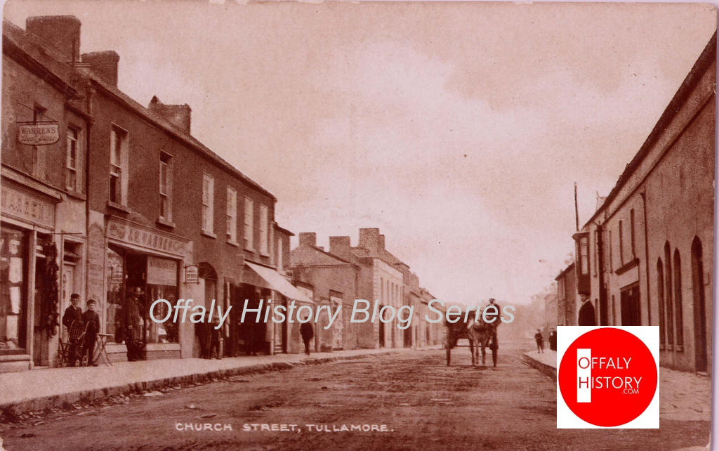
Church Street was no more than a laneway in its early years and its principal building was the Protestant church in the area that served as the Shambles from 1820 and was later the Country Market and Bracken’s/McCann’s shop. The oldest part off the street is to the west from the access to what is now Market Square to the junction with William/Columcille Street.
The street was widened from near the present Methodist church and the new bridge on the river completed in about 1795, later called Pound Bridge. There are no lanes on the southern side of the street because there was no access to the lands across the river (save behind the present-day library) and the southern side backed on to the Tullamore River.

The northern side of Church Street has varying dates with the church of 1726 the earliest building and joined in 1925 by the Foresters’ Hall and in the 1980s and 1990s by the new Unity Hall and the Chinese restaurant.
Institutional buildings were five in number when the public inn is included:
- The first Protestant church in Tullamore of 1726 and out of use from 1815.
- The Methodist church of 1889 is on the site of not one but two earlier Methodist churches that of 1788 and that of 1814.
- The County Infirmary (now Library Hall) of 1788 and in use as a public library from c 1942 to 1977 or 35 years.
- The former Charleville School of 1811.
- The Tullamore town hotel of 1785, known as Doherty’s by 1800 and for many years as Hayes’ Hotel (demolished in 2000 to make way for what is now Boots Pharmacy). It was a public building in that it served the public and survived for almost 215 years. It may have been older but we can consider that later.
All the public buildings have now gone out of use for their intended purpose save the Methodist church where the same site is still in use but in the third building on the site. With five public buildings in use the street was an important thoroughfare at least up the coming of the one-way system in c. 1964 and the restricted parking.
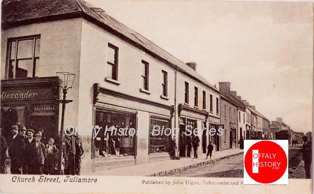
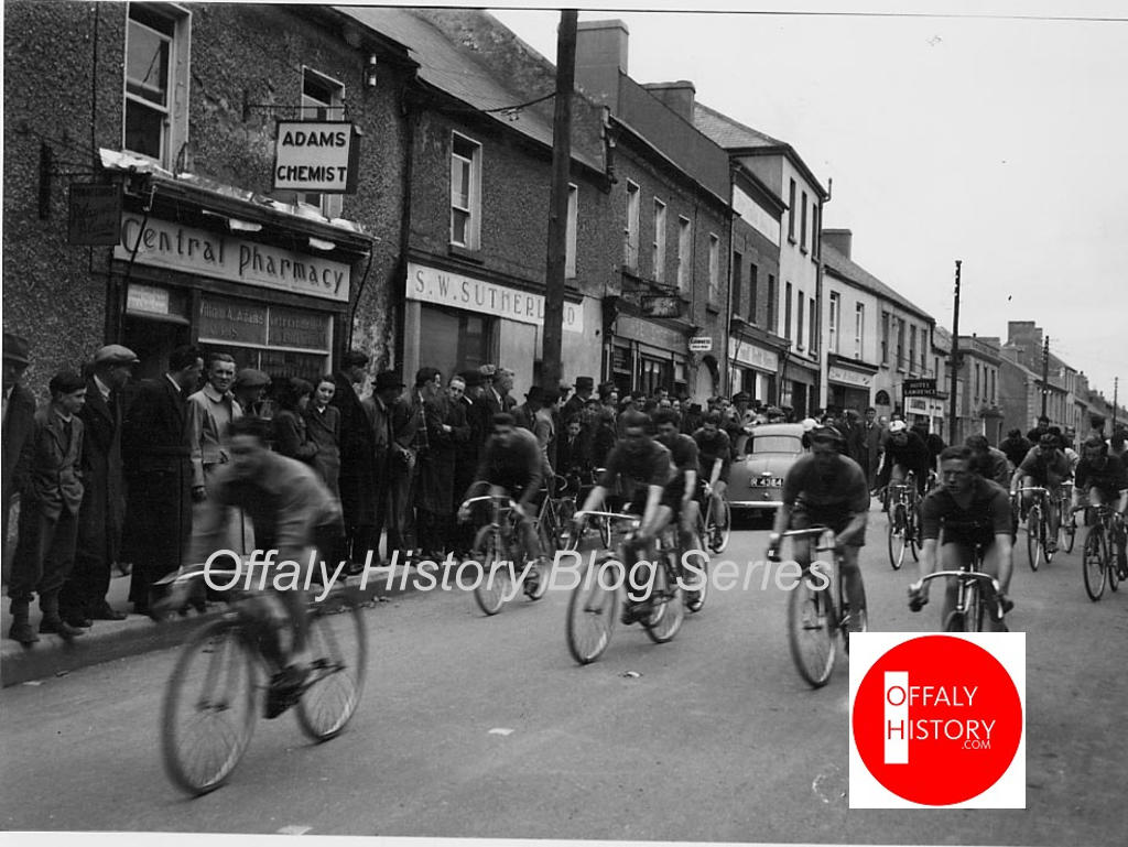
Over the course of the articles we look at these uses and the changes. We have also the shops and private houses to review and the private and business families who lived in them. Being near the market place pubs were strong on the street with Wyer’s, Lee’s, Hole in the Wall (Egan’s) and two more near the Champs drapery stores, and that is not including the hotel. Up to the 1970s there were no shops on the southern side of the street save the hotel and Clarke’s barbers. These were followed by the 1970s with Benny’s Flowers, Davis Footwear and auctioneers – (three firms at one stage) including Brendan Dunne’s and Liam Keegan’s.
Church Street provided an access to the fairs held in the Market Square and in O’Carroll (Henry) Street. I was told lately by Mr Cummins that the area in front of the old infirmary was used by the Travelling Community for the sale of horses and donkeys.
Church Street was a good-quality residential area (especially on the terrace between the Methodist church and the library/infirmary but it began to weaken in the 1960s and 1970s as the one-way system and restricted parking began to be felt. The three-storey terrace was converted in some cases into rented rooms and flats and the houses allowed to deteriorate. Church St was on a par with Cormac Street and O’Moore Street but did not have any particularly good houses (ie rated over £30).
The first valuations of 1843–54 provide a good indication of status of housing on the street. Church Street in the printed Griffith Valuation (1854) had 57 rated units of which 56 were buildings and one the pound. The pound was west of the river on the southern side and close to what is the Lidl site and buildings today. The infirmary and hotel buildings were rated at £37, or similar to the very large houses in High Street. The terrace on the south side was averaged £7 or similar to the houses in O’Moore Street south (Victoria Terrace). Thomas Stirling’s houses west of Lee’s Bar were close on £15 each and the Magill shop (later Morris) was £13. In the course of the forthcoming articles we can look at the 1843 valuation and those post 1854.
Church Road was further developed from the 1970s with new suburban housing and in the 1980s a new shopping centre still trading today and due to be expanded. On the western side of Church Road was the bacon factory and creamery where up to 100 people, mostly men, were employed up to the late 1980s (now mostly the site of the second Lidl supermarket).
Drapery stores trading since the 1900s, and before, began to suffer out when Dunnes opened in 1968 in Patrick Street.
New buildings on the northern side included Unity Hall of the FWUI and Jimmy Wan’s Chinese restaurant. The latter was beside Pike’s or Market which provided one of the two direct access routes to the square.
Looking forward to your assistance with the Church Street articles. Call to Bury Quay or email info@offalyhistory.com