23 May 2026 Saturday, Tour of Shannonbridge depart at 10 a.m. from Offaly History Centre (let us know if you can share or need a lift). To meet at Shannonbridge at the Old Fort across the Bridge at 11 a.m. Our guide is Declan Ryan. Starting with coffee, followed by tours of the forts, the river and the town. To conclude about 1.30 p.m. with lunch at Killeen’s (you need to book this yourself). This is an excellent venue so why not make it a day out and bring the family and friends. Declan will be an excellent guide Note Sturdy Footwear required for uneven ground and long wet grass. And on Friday evening in Banagher….
TALK ON ARMSTRONG FAMILY HISTORY 22 May 5 p.mby Eduardo M. Garcia Fernandez Saenz from Buenos Aires
Local history enthusiasts are in for a real treat next week when Eduardo M. Garcia Fernandez Saenz from Buenos Aires will give an important talk on his Armstrong ancestors, in particular Thomas St. George Armstrong who was born in Garrycastle, Banagher, in 1797. At the early age of twenty Thomas went to Argentina and between then and his death in 1875 he became a very successful businessman, married into aristocratic society and also became an adviser to the rulers of Argentina. The talk will be held in Crank House, Lower Main Street, Banagher at 5 p.m. on Friday 22nd May. The event is organised by Offaly History and all are welcome. Enquiries to James Scully at 085 710 7569.
I grew up on a small farm beside Lemanaghan Bog, and to this day I can still feel the rhythm of those summers spent wandering up and down the lane that led from our 150 year old farm house to the bog. It wasn’t just a lane, it was an enchanted corridor. The hedges were alive with native flora and fauna, and as children we were convinced there was something mystical about that stretch of road. Maybe it was the way the light filtered through the trees and hedges or the rustle of wings from creatures we could never quite see. Whatever it was, it shaped our imaginations long before we understood the world beyond it.
From the top of the lane, the view swept across the bog all the way to the Kinnitty Mountains which is what we called them then, though of course they are the Slieve Blooms. Their colour changed with the weather: soft blues on warm days, deep purples in the evenings, and that unmistakable dark, heavy shade that meant rain was on the way. Some days they felt close enough to touch, other days they drifted away like a dream. That shifting landscape was the backdrop of our childhood.
I was lucky, truly lucky, to grow up with my grandparents. Not everyone gets that gift. They filled our days with stories, traditions, and the kind of work that didn’t feel like work until you were old enough to realise it was. As a small children on the bog, we were more of a hindrance than a help, too busy chasing frogs, spotting bog lizards, or watching butterflies and dragonflies dance over the bog waters. If you had to go in evening, you would get ate alive by midges and it would cause great distress but of course knowing that they are a vital food source in a healthy ecosystem, was good reason enough to put up. It was magical, and we didn’t know it then, but those were the moments that would stay with us for life.
Of course, when you got older, the magic didn’t excuse you from the reality of saving turf. As the saying went, “If you want to keep your arse warm for the winter, you need to help save the turf.” At the time, I thought it was hardship. Other families didn’t have to go to the bog, and I envied them. But looking back now, I see it differently. Those balmy summer days, the laughter, the bottles of water buried in a bog hole to keep cool, the quiet companionship, they were some of the happiest times of my life.
A Landscape Layered with Time
What makes Lemanaghan truly extraordinary is not just its beauty or its wildlife, but the sheer depth of history held within its soil. This landscape is a tapestry woven from thousands of years of human presence — Mesolithic hunter‑gatherers, Neolithic farmers, early Christian monks, medieval pilgrims, and the families who still live here today. All of these eras sit side by side, layered gently through the bog, preserved in a way that few places in Ireland can match.
Across the bog, the old toghers still lie beneath the surface — wooden trackways built by our ancestors to cross the wetlands long before roads existed. Some date back to prehistory, others to the early Christian period. In recent years they’ve been called pilgrim paths or mass paths, but whatever name they carry, they are proof of continuous life, movement, and devotion across this landscape. These paths connect us to places of deep significance like Clonmacnoise and the Hill of Tara and are the only remaining paths from our past that we have. They need to be protected. Generations walked these routes with purpose: to travel, to worship, to trade, to survive. When you stand on the bog today, you are standing on the same ground they crossed.
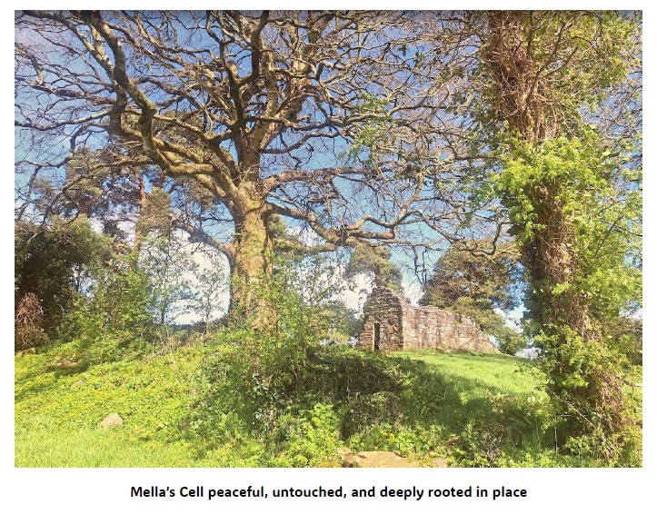
One discovery in particular brought this ancient world sharply into focus. In 1998, part of a bog body was uncovered in the townland of Tumbeagh. It was a remarkable archaeological find — a direct connection to a person who lived and died here centuries or even millennia ago. Maybe a native to the are or a pilgrim who lost their way. But the circumstances of the discovery were a stark reminder of the cost of industrial peat extraction. The body was found during the milling of peat, and some of the remains had already been sent to a power station and burned as fuel before anyone realised what they were. It was heartbreaking, and it showed clearly that these peatlands are not wastelands or empty spaces waiting to be exploited. They are sacred ground, holding the stories and the bones of our ancestors, much like the recent discovery back in January 2025 at Mella’s Cell when storm Éowyn swept through the land and with it, it brought down trees in Mellas Cell. Yet another discovery was made. Human remains from over a thousand years ago were uncovered. This was the first time it was realised that this was in fact a sacred burial grounds. These ancient trees had managed to fall but avoided falling on the remaining structure of Mella’s Cell as luck would truly have it.
The Changing Bog
When Bord na Móna took over the bogs, the land began to shift in ways we didn’t fully understand at the time. Drains were cut long before harvesting began. My granddad was deeply uneasy about it. He knew — instinctively, from a lifetime on the land, that this kind of change wasn’t good for the landscape. But compulsory purchase orders came, and people had no choice. You accepted it and got on with it, because that’s what rural people did.
Over the years, natural springs and wells that had flowed for generations dried up. Water tables dropped. Getting water to cattle became a more difficult task. The land we knew began to alter under our feet. And yet, for many families, Bord na Móna meant jobs, stability, a way to support children. It was a trade-off that people felt they had to endure it seems.
But there were other consequences too. Fires on the bog were not unusual, especially during long hot spells. Many of them were never acknowledged by Bord na Móna, even when the community knew exactly how they had started. The most recent major fire in the late 2010s is still fresh in people’s minds. We were not long moved into our new house when it happened. Homes were filled with smoke, belongings destroyed, and yet when people reached out for help, nothing was done. That memory lingers — not just the damage, but the feeling of being dismissed.
A Community Under Threat Again
And now, here we are again.
The community around Lemanaghan Bog is facing another upheaval, this time in the form of a proposed wind farm: fifteen turbines, each 220 metres tall, right through the heart of the bog. People are angry, upset, and deeply worried. The consultation process felt deceitful from the start. A semi‑state body has enormous power, and they know it. They can pressure, divide, and buy silence. What was once a company rooted in community has become something unrecognisable, one determined in causing division and willing to fracture the very places and people it once relied on. These places have helped people heal in the greatest time of need and I can vouch for that personally. In times of grief, all one needs sometimes is solace and time to reflect and remember in peace. Lemanaghan Bog gives us all of that reminding us each of our life times are short and that we are connected through generations that went before us and their presence is still there it just appears in a different form. In that there is comfort.
For many of us, especially during COVID, the bog was our sanctuary. It was the one place we could walk freely, breathe deeply, and feel grounded. It is still the most peaceful place you could wander. But if the machinery comes — the diggers, the cranes, the convoys of lorries — that peace will be shattered. The wildlife that has survived generations of change will be displaced. The delicate ecology of the bog will be torn apart. And all the “surveys” carried out over a few rushed days here and there will never capture the depth of local knowledge that has been passed down through families like in our communities.
Our fear is simple: that once again, the people who live here — who love this place, who understand it — will be ignored. And if the project becomes inconvenient, BnM will simply sell it on, as they have done in other areas, leaving the community to deal with the consequences. There are some things that money simply can not buy and connection is one.
Growing up beside Lemanaghan Bog taught me the value of land, heritage, and memory. It taught me that these landscapes hold stories, and that communities are shaped by the places they belong to. What worries me now is that those stories — our stories rich in heritage— are at risk of being drowned out by decisions made far away by people who will never walk that enchanted lane or watch the Slieve Blooms change colour with the weather.
All we want is to protect the place that shaped us. You don’t need to be deeply religious or even believe in anything in particular, but when you have a deep connection with the land that you live upon, you just know that an area is not suitable for what is being forced upon it. I believe that our ancestors will rise to help us whether it is to show people that they need to lay off and choose more suitable places to build their energy plants. This is not suitable or natural place for industrial wind farms. We need to protect our peatlands.
Down in the Jetty. In your early childhood? Yeah.What form of lighting was used down there?
Hurricane lamps. All the time. All the time
There was always a few hurricane lamps here and you’d light up and walk down with this hurricane lamp hanging out of you and, you know,
And that was in the office and in the store.
Oh, yeah. No other light only paraffin oil, hurricane lamps. During the time that the boats were traveling night and day, they always had a red light up in the stern of the boat.
That’s up on the front of the boat?
Yes. Just as one board could see another.
And what? These lamps.What fueled the lamps?
Just an ordinary pony and trap lamp, you see, with a candle in it. And that’s all just red surround. Well, that was before the all night traffic stopped. There was a big strike, and there were several boats tied up here.
My grandfather, Henry Robinson, was born on the 18th of November 1920 and lived his entire life in the countryside between the villages of Belmont and Cloghan in County Offaly in Ireland.He grew up on a small strip of land between the River Brosna and the Grand Canal.
It was on the Grand Canal where his own father, G.R. worked on the local jetty, unloading goods and acting as an agent for Guinness.The Grand Canal to Shannon Harbour was opened in 1804, and for some 150 years was a vital industrial thoroughfare linking Dublin with Limerick.
The canal ran from the centre of Dublin and through the Irish Midlands until it met the River Shannon.Barges would travel along the canal and then down the Shannon and across the waters of Lough Derg, until they reached the city of Limerick.
Over the course of several months in 2003, my aunt Sandra Robinson sat down with her father, my grandfather, and recorded some 24 hours’ worth of material on cassette tapes detailing his life and his knowledge of farming, milling, the canal trade and the history of the Belmont area of West Offaly.I have digitised and remastered these recordings in order that they be preserved for posterity.Here I present some 35 minutes of cut together with material detailing my grandfather and great grandfather’s experiences working on the Grand Canal.
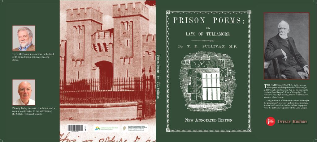
28 March Saturday at 11.00 a.m. at the former Tullamore Prison/Kilcruttin Business Park, Cormac Street, Tullamore, for the Launch of anew edition of Prison Poems or Lays of Tullamore by T.D. Sullivan, edited by Terry Moylan and Padráig Turley. Sullivan like William O’Brien and John Mandeville were political prisoners who refused to wear the prison clothes.
See Cormac Street from a new perspective
Jacket of the new edition of Prison Poems
Today we are reminded of the jail every time we stop at the lights at the junction with Cormac Street, Kilcruttin and Charleville Road and look to the magnificent limestone façade, memorial tablet, jail warders’ cottages and the very fine gates with their Roman fasces to remind us of the symbols of authority back to early times. Then who has not heard of the underground passage (now mostly closed off) that allowed the prisoners to be brought into one of the two semi-circular courts in the old pre-1922 courthouse.
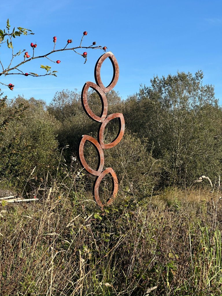
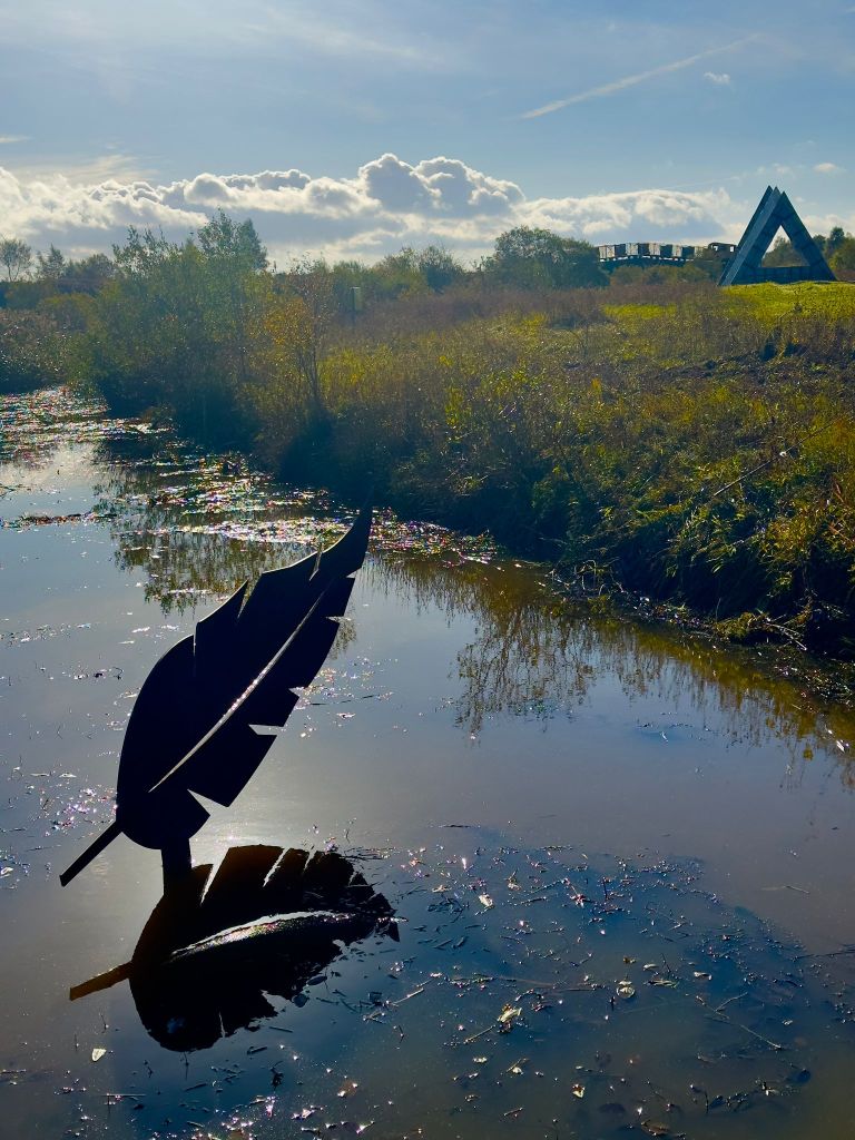
Two new sculptural works by artist Kevin O’Dwyer have been officially launched at Lough Boora Discovery Park, marking the first major additions to the park’s sculpture collection in over a decade. The works, titled Regeneration and Light as a Feather, reflect the park’s evolving story of transformation from industrial peatlands to a landscape of ecological restoration, culture and public enjoyment.
Regeneration draws inspiration from the seed as a symbol of renewal, growth, and cyclical change. Rising vertically from the ground, the work acknowledges the industrial history of the site while pointing toward its continued regeneration.
Light as a Feather offers a contrasting visual language — a suspended, airy form that engages with space, balance, stillness and the quiet expansiveness of Boora’s open horizon.
“Lough Boora is a place shaped by change, resilience and imagination,” said Kevin O’Dwyer. “These works are rooted in the landscape’s capacity to hold memory while continually becoming something new. O’Dwyer says it has been an honour to contribute to this next chapter in the park’s cultural and environmental renewal.”
Walk around Tullamore’s canal quarter with Michael Byrne as guide. Find out where was Charles Street, Deane Place and Gas Works Lane. Where did Lord Tullamore live before the family moved to Charleville in 1740. When did the canal arrive. Was there a barracks there before that? Where was Pentland’s Distillery. Who was the Thomas in Thomas Street? Find out where the largest meeting in Tullamore was held and why. Take care and thanks to our yellow-jacketed stewards Shaun and Pat and to Helen and friends for assistance with the teas.
We meet at Offaly History Centre, Bury Quay (beside new Aldi and Tullamore Old Warehouse restaurant) for ease of parking from 10 30 a.m. All are welcome and the tour is free. Tea/Coffee/scones available from Offaly History Centre from 10. 30 a.m. Bathrooms available. We walk to Harbour Street through the new Aldi car park (over the former Williams oats store and Irish Mist warehouses and into Offally (sic) Street or Wheelwright Lane).
Harbour Street
Developed over the period from 1800 to 1825 it could be described as the opening to the canal quarter facilitating access to the new streets at Deane Place, Market Square, Chapel Street, Store Street, Gas Works Lane and O’Carroll Street. Surprisingly for such a great artery it was never an important trading street. The harbour takes up much of the eastern end of the street together with the great distillery of the 1820s – now the Granary apartments. The original name here was Charles Street and this can be seen carved in stone on the corner with O’Carroll Street.
5 July, Saturday morning from 11 to 12 30 p.m. Walking tour of Tullamore town: Patrick Street and Church Street with Michael Byrne. Explore the history of these old streets dating back to the 1700s, from the military barracks of 1716 to the church of 1726, county hospital of 1788, the Methodist chapels (4) and the families and shops over 250 years. Find out what is left of the old barracks; where was Swaddling Lane and Pike’s Lane, the linen factory. Who was the Henry in Henry Street – and so much more.
We can meet outside Offaly History Centre, Bury Quay (beside Old Bonded Warehouse restaurant) for ease of parking from 10 45 a.m. All are welcome and the tour is free. Teas/Coffee and bathrooms available from Offaly History Centre from 10. 30 a.m. A big welcome to Birr IGS members who are planning to join the tour.
12 July Saturday morning from 11 to 12 30 p.m.Walk around Harbour Street, Store Street, St Brigid’s Place, the Harbour and O’Carroll Street with Michael Byrne. We can meet outside Offaly History Centre for ease of parking from 10 45 a.m. All are welcome and the tour is free. Coffee and bathrooms available from Offaly History Centre from 10. 30 a.m. Tea and scones available.
How often have we seen relatively small scale and cheap solutions deferred in the expectation that more ambitious longer-term projects will arrive at some future date to solve everything? Frequently the costs of the more grandiose schemes balloon over time and their implementation indefinitely deferred or even abandoned. Meanwhile the problem gets progressively worse – often to the point that any solution becomes unrealistic.
While the making of good long-term plans must always be pursued, the delivery of shorter term and achievable remedies should not be easily dismissed. Two high profile projects in the Tullamore area offer classic examples of the dilemma.
This blog post will trace the decline of the canal as a means of transport and critical element in the economic development of Edenderry and the surrounding area. The transition of the canal and harbour as a tourist and leisure amenity will be discussed further on. The introduction of the railways in the mid-nineteenth century weakened the canals importance to the economy. Both the canal and railway had to compete for the limited inland trade. A struggle the canal was also going to lose.[i]
In the summer of 1846 it was reported that the people of Edenderry had averted an accidental breach in the branch canal to the town harbour.[ii] Another serious breach occurred between Ticknevin lock (20th) and the Blundell aqueduct in February 1849. The breach occurred in the bog embankment.[iii] The repairs were carried out under the Grand Canal Company’s (G.C.C.) new engineer, Christopher Mulvany. While repairs occurred Mulvany constructed dams and laid a tramway along the canals north bank allowing trade to continue. If the first half of the nineteenth century saw the rise of the canal as a revolutionary mode of transport, so too can the railway be seen to replace the canal.
‘Map of the canal and railway lines’, Ruth Delany, The Grand Canal, figure 23.
In 1835 Thomas Murray derided the idea of the possibility of a rail link to Edenderry:
‘There is nothing to be sent from this but a few passengers which only fill about three or four coaches every day and which will not pay almost anything.’[iv]
Although the Midland Great Western Railway (M.G.W.R.) and Great Southern and Western Railway (G.S.W.R.) both showed an interest in buying the G.C.C. in the 1850s, nothing came of it, and the Company remained independent.[v]
In 1871 before the beginning of the Land War, the Downshires still owned 14,000 acres of Edenderry as they had done at the beginning of the century, now with an annual rental of £6,800. The M. G. W. R. established a train station in Edenderry in 1877. It had reached Enfield twenty-seven years earlier. By the 1880s traffic on the canal had begun to decrease, although the G.C.C. was still running at a profit. In 1888 the Alesbury brothers moved their premises to the Grand Canal and built a factory there. The Alesburys used their own canal boat to transport timber for use in making furniture.[vi] In 1911 the G.C.C.’s engineer, Henry Wayte, was allowed by the Board to become the Irish agent for Bolinder engines and four of these were fitted. By 1911 the G.C.C. was converting its horse-drawn fleet to the Bolinder diesel engine. By 1914 twenty-eight canal boats had been converted to Bolinder engines.[vii]
‘Breach at Edenderry, 1989’, Safe harbour, p. 17.
In 1916, again, there was a breach in the canal at Edenderry in the north bank of the canal near Blundell Aqueduct. On 11 January 1916, 300 yards of bank were carried away. Wayte had dams erected to try and keep trade moving and to help in bringing clay to the sit. The Leinster Leader vividly depicted the aftermath of the breach:
‘…no description, however graphic, could have prepared them for what they saw-the havoc wrought by the muddy rushing water, the enormous force that must have pressed it outwards, the utter impotence of the protecting line to resist the pressure and the great cataclysm that resulted….Again the breach took place on exactly the same spot as the great breach of 60 years ago.’[viii]
The cause of the breach was attributed by Gordon Thomas, engineer to the Grand Junction and Regent’s Canals, to ‘boisterous weather’ and ‘heavy rainfall.’[ix] Soon after Wayte decided to use three rows of new piles, backed and filled in with clay and bog material. Work in February was hampered by gales and snow with the workers exhausted. In March snows and blizzards continued to slow down progress. In early April, Wayte was able to report in his weekly report to the G.C.C. Board that the repair work had been completed.[x]
From 1917 to 1920 the government subsidised maintenance costs of the canal and paid war bonuses to the G.C.C. employees.[xi] During the Civil War conflict erupted on the canal when stores were burned and boats were attacked. By 1922, with the end of the revolutionary period, the Downshire estate consisted of 6,780 acres, most of it being unleased bog land. And in 1923 with the passage of the Irish Free State’s Land Act, the process of land purchase was completed. In 1950 the Grand Canal was nationalised under Córas Iompair Éireann at a cost of 1.25 million.[xii]
With the development of the River Shannon as a tourist amenity it was shown the Grand Canal still had a post-nineteenth century role for the Irish economy. The final barge to leave Edenderry Harbour was the 48M Canal Barge in May 1960, ending over 150 years of service.[xiii] The Edenderry branch had become impassable with weeds and was cleared and reopened for the opportunity tourism brought with it. An advertisement for the sale of the warehouse at the harbour, as part of the winding up of the financial use of the canal, was placed in the Offaly Independent in October 1960.[xiv]
‘Last barge, 1960’, Safe harbour, p. 26.
The canal breach of January 15th 1989 was the worst seen since 1916. 400 meters of the north embankment broke away at the midway point between Blundell Aqueduct and the Edenderry line.[xv] £1 million worth of damages was caused by the breach.[xvi] It would not be until March 1990 that the Office of Public Works would complete the repairs of the Edenderry canal.[xvii]
Stephen Rynne summed up the canal’s history as:
Fifty years in the thinking-out and arguing; fifty years in the making; almost fifty years flourishing; over a hundred years staggering along and not knowing from year to year when the final blow would fall.[xviii]
Since the 1990s festivals have become a recurrent sight during the summer season in Edenderry harbour. Canoeing too is popular today on the canal along with fishing. Among the fish inhabitants of the canal are roach, bream, perch and pike.[xix] The local inhabitants of Edenderry and the surrounding townlands and villages use the canal year-round as a walking route. The successful transition of Edenderry harbour and canal into a leisure and tourist amenity has given it a new lease of life into the twenty-first century.
‘Map of the canal and railway lines’, Ruth Delany, The Grand Canal, figure 23.
[i] Ruth Delany, A celebration of 250 years of Ireland’s Inland Waterways (Belfast, 1992), p. 5.
[ii] Delany, The Grand Canal (Newton Abbot, 1973), p. 165.
[iii] Delany, The Grand Canal of Ireland (Dublin, 1995), p. 175.
[iv] W. A. Maguire, ‘Missing persons: Edenderry under the Blundells and the Downshires, 1707-1922’ in William Nolan and Timothy P. O’Neill (eds), Offaly: history & society (Dublin, 1998), pp 515-42 at p. 537.