Last week we set out reasons why Cormac Street can be considered so good. Anybody getting off the train, visiting the town park or the courthouse cannot but be impressed. The street is very largely intact since it was built and has been enhanced by the town park. The restoration of the full Kilcruttin Hill beside the folly should be undertaken by the municipal council given its historic importance. Charleville/Cormac Street was the outer extremity of the town when building started here in the 1780s. Probably the Elmfield house (now the location of the Aras an Chontae) dates to 1795. Both Norris of that house and Acres of Acres Hall (dated to 1786) were functionaries of the young landlord’s family and both built on the road to the demesne. Bury came of age in June 1786 and so could regulate matters himself. While there were some cabins on Charleville Road these were temporary structures and aside from Elmfield no building leases were granted here until that to Daniel E. Williams in 1898. He completed Dew Park by 1900 and it was then regarded as the best house in Tullamore having taken that honour from Acres Hall. It reflected changing times with the demise and relative impoverishment of the Acres family and the growing importance of the new Catholic merchant class of Egan’s and Williams. While Williams had a virtual freehold in Dew Park lands the Egan family took a long lease from the Acres Pierce family of Acres Hall in 1891. The third big house that of Elmfield may well have earned the first-place honour but the Goodbodys sold this house in the 1880s and moved to Dublin. Richard Bull, the sub-sheriff moved in and departed after 1904 when the house was taken by Dr Kennedy who had moved from The Cottage in O’Moore Street.

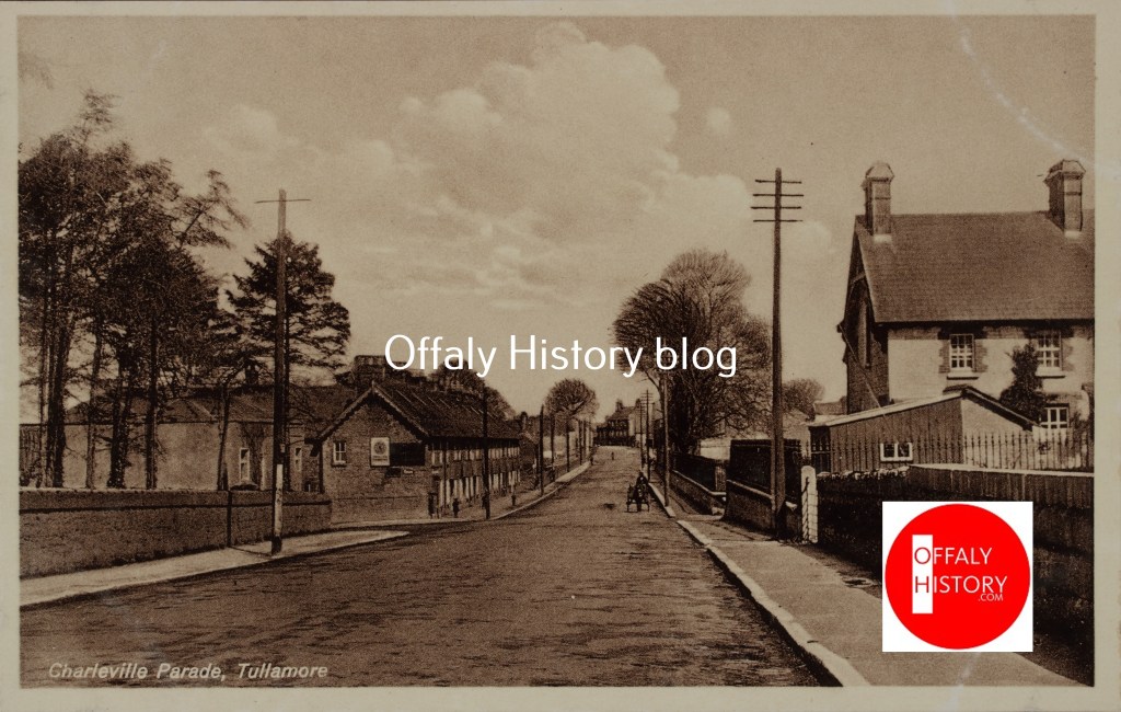
Cormac Street is a wide street with a particularly good terrace of houses between the Adams house on the corner with O’Moore Street and the courthouse dating to the 1800s.The street is still largely residential with one shop now and some houses converted for office use. Back in the twentieth century it had Lloyd’s (later Moore’s shop) and Kemmy’s. Near the courthouse was a small bakery operated by the Behan family. Cormac Street or Charleville Street/ Charleville Parade as it was once called, is on the approach road to Charleville Demesne and has very good houses at the junction of High Street, O’Moore Street and Cormac Street together with the terrace between this large three-storey over basement block and the courthouse. At the other end and set back from the street are the former jail (1830), the courthouse (1835) and on the southern extremity of the town prior to the development of Charleville Road after 1900. The railway line dates from 1859, the station from 1865 and the road from Kilcruttin only in 1938. This new road was to facilitate access to the Salts’ worsted mill built on the gaol site in 1937-8. Prior to the 1900s Cormac Street was one of the best areas in town, but after 1900 and the development of the motor car the focus of attention moved to Charleville Road and to a lesser extent Clonminch Road.

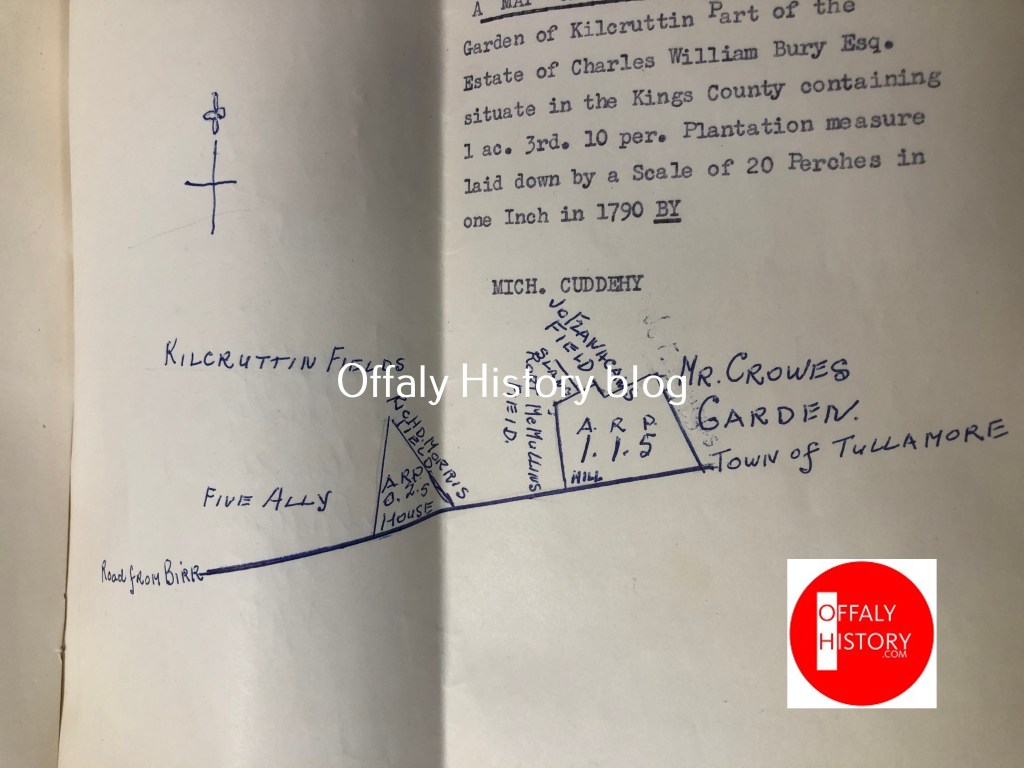
In the early eighteenth century the roadway or street here was known as the road to Redwood (now Charleville Demesne), on the way to Birr. When the name Redwood was changed for Charleville about 1740 it became known as Charleville Road and with the building of the houses here Charleville Street or Charleville Parade.[1] The name Charleville Road is now reserved for the roadway south of the railway bridge. The name of the street was changed to Cormac Street by the urban council in 1905. Charleville Parade is still used by some people to describe the row of houses from the town park to the old lane to Kilcruttin graveyard. In the 1880s the terrace between the house now occupied by Brian Adams and Wellington Barrack was known as Charleville Place. Kilcruttin Lane, at the southern end of the terrace opposite the gaol did not merit attention in 1843-54 as part of the valuation survey but was noted in the 1901 census.
On that walking tour on 13 July, we looked at stages in the development of Cormac Street and these can be enumerated as follows:

- The building of Acres Hall by Thomas Acres (now the home of the Tullamore Municipal Council. This house is dated to 1786 and looked over to the 1720s windmill built on the hill of Tullamore.
- The completion of the terrace on the western side as far as Deverill Dolan’s office over the years 1786 to 1800. However, three houses here have been rebuilt – that of Clancy’s in the 1970s and the two houses south of it in 1898 by long-standing builders in Tullamore – the McMullen family.
- The lands of the town park today were never built on being soft ground and close to the Kilcruttin Cemetery. This cemetery may date from the 1700s to 1750s, but the earliest tombstone located is only 1770. These lands were let for grazing and did not form part of the Acres Kilcruttin Hill lease.
- The triangular piece on which ten houses were built for the Acres Pierce estate in 1879-80 had a common garden to the rear – at least until the 1960s. Prior to these houses it was occupied by cabins let by Acres (d. 1836) and latter his son-in-law Dr Pierce (d. 1859).
- The yellow brick house at the junction with the Kilcruttin Road probably dates to 1830 but with modifications for the railway company in 1865.
- The new railway station was built in 1865 and replaced that at Clonminch.
- The site for the jail and the courthouse were reserved by the Charleville family possibly as early as 1795 given that the Windmill Hill lease boundary was the present Dr Delaney’s house north of the courthouse. The terrace of four house in the jail grounds date to 1889.
- The jail was started in 1826 and finished in 1830. It remained in use until January 1922 and was burned by the departing Republicans, as was the courthouse and barracks, on 20 July 1922.
- The terrace from Delaney’s to Adams dates from c. 1800 to 1840 with the Adams to Tony Flanagan terrace about 1800 and four of the six houses at Wellington Barracks may date from c. 1810 while the two big houses are grander and later.
- The street had two lanes – the oldest was that leading to Kilcruttin Cemetery and is now closed off and lands incorporated in other holdings. From the early eighteenth century to recent years access to Kilcruttin graveyard was via this laneway at the southern end of the terrace of 1879.
- On the eastern side of the street near the courthouse was Wellington Barracks (after 1905 known as Coleman’s Place). The four houses between the lane and the site or what are now the two tall houses near the courthouse (nos 515-6) were built for army offices to the front of what was a rectangular square with the entrance from the middle of the laneway. At the end of the war in 1815 the barracks was adapted for use by civilians renting from Acres. The two large houses to the south of Wellington Barracks and north of the courthouse were built about 1840. Coleman’s Place was a very poor place from the time the army left after 1815 and for the next 100 years.
Cormac Street and Coleman’s Place in 1821 and 1901, Kilcruttin Lane in 1901
In 1821 Charleville Street, as it then was, had a population of 215 people living in 46 houses. at least half of which were probably thatched single-storey and this probably included Coleman’s Place. In 1821 some twenty-two houses can be accounted for as in the first and second class, leaving thatched houses possibly in the vicinity of the site of the 1879 terrace of ten, the site of the railway station and Kilcruttin Lane (the access road to the cemetery). In 1901 the street had a population of 326 with forty-one families and forty-one houses. All the houses were now slated and stone-walled and eleven of them were placed in the first class and twenty-eight of them in the second-class category. The outbuildings included nine stables, four coach houses, five cow houses, a dairy and four fowl houses. With such a high population one would have expected subdivision of some of the houses, but in fact the high density is explained by the number of prisoners in the gaol which in 1901.
Coleman’s Place in 1901had a population of forty-one with nine inhabited houses and nine families. The houses were all slated and stone-walled and were placed in the second class. The outbuildings included a stable and three piggeries. What is surprising is that given the state of the buildings they were all demolished by the 1950s.
Kilcruttin Lane was not separately noted in the 1840s and was most likely included with Cormac Street and houses not to be valued. In 1854 these houses were probably listed as in Kilcruttin townland. The structure of buildings can clearly be seen on the 1838 five-foot map and in the 1888 map. The latter map suggests four small houses and in 1901 the lane had twenty residents comprised of three families in three houses.
On Saturday 27 July Acres Hall and Thomas Acres
[1] See recital in Registry of Deeds, 1 June 1713, Moore and Lyons to Gale, memorial no., 41/393/26491; Manor court book, 18 October 1798.
