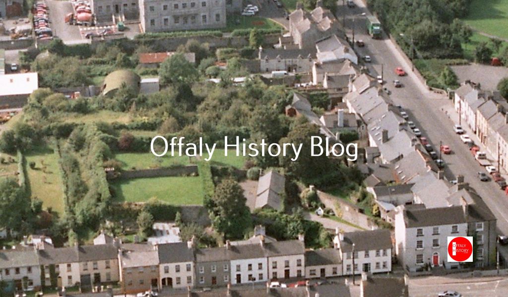
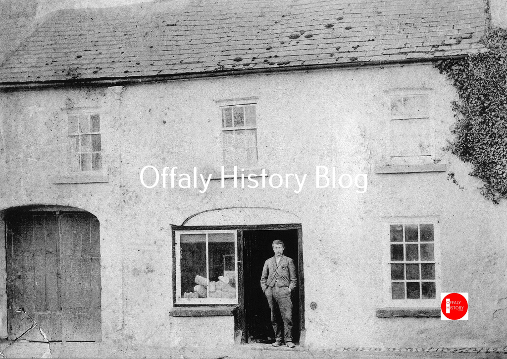
In this article we are looking at the houses from the courthouse to the junction with O’Moore Street. The area was residential but with the two big public buildings – the jail and the courthouse, and across from the courthouse was low-lying land used for farming purposes and in the corner the old town graveyard. For a decade or so from the mid-1830s two of the houses were transformed into a hotel to serve the courthouse and assizes among others. It was in house GV 13 that Benajamin Woodward was born in 1816 and described as ‘the most celebrated and original architect of nineteenth-century Ireland, designing over sixty buildings in the last twelve years of his life.’ We start with no. 14, the three-storey over basement house on the corner with the two faces – one to O’Moore Street and one to Cormac Street. The houses are numbered in Griffith’s printed valuation of 1854 (see image) as being numbers 3 to 14 and were built on the Windmill Hill site that Thomas Acres obtained from Charles William Bury, the town’s landlord, in 1795, supplemented in the late 1830s with land for the two big houses beside the courthouse.
The demand was coming from town growth in the period from 1786 to 1815. Some of this demand was as a result of the war with France from 1793 to 1815. We need also to take account of the construction of the canal to Tullamore in 1798. As already explained in previous articles there was a burst of activity after almost 21 years of the minority of the town’s landlord, Charles William Bury. He was born in 1764 and came of age in 1785. He set about reorganising the town in terms of site availability, the provision of the town’s hotel (1785), market house (1789), new streets, landscaping Charleville and building the castle from 1800 to completion in 1812.
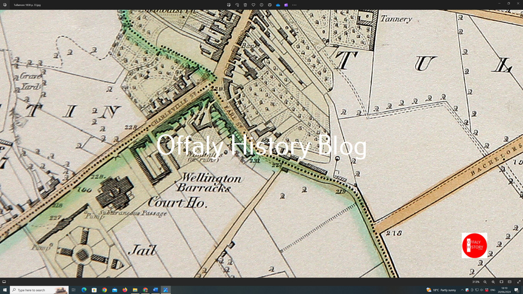
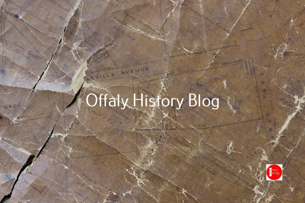
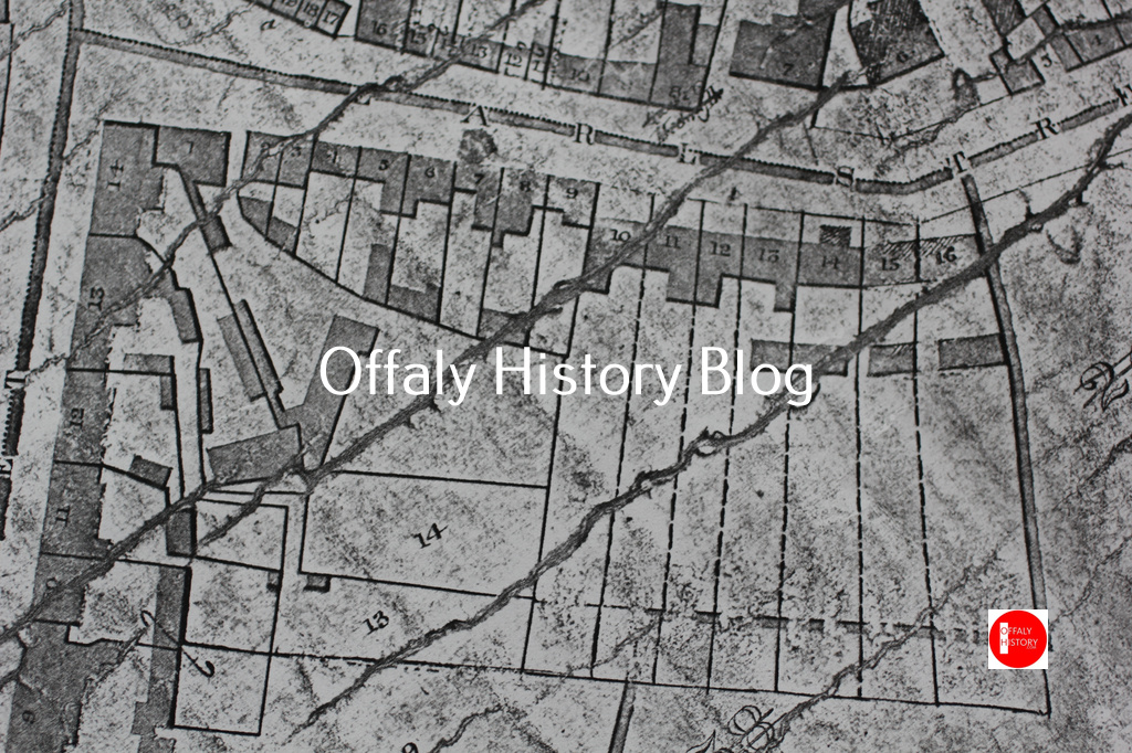
The Cormac Street east houses are on the Windmill Hill site. Facing Cormac Street this had a frontage to the street of over 483 ft., 247 ft to O’Moore Street and on the east side mearing Windmill Hill field 508 ft. The front to Cormac Street east provided ground for eleven or thirteen houses to the street and later 12 houses or cottages in what was the Wellington Barracks Lane, called after 1905 Coleman’s Place. Studying the maps will help here.
We are fond of the five stages in various building schemes in Cormac Street (see earlier blogs) and yes five can be identified here also on Cormac Street east:
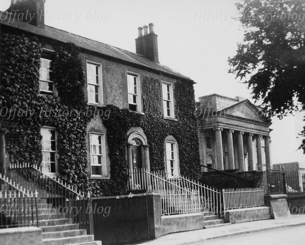
- The house no. 14 of the Adams family (along with 1 O’Moore Street) (Bannon’s) is the earliest house on Cormac Street east and can be dated to 1795-1805. It was used as an infantry barracks in the early 1800s.
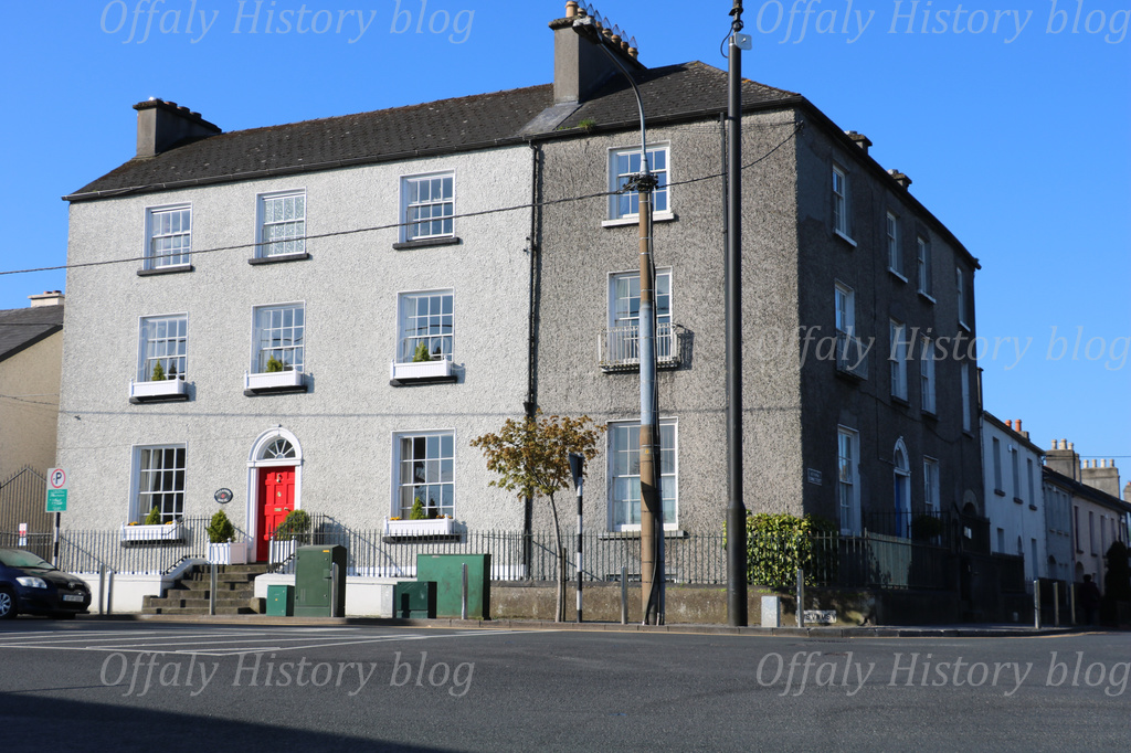
- The former McCann’s house (now used as offices for Jigsaw) was next and is of the same period. This and the next five were used as officers’ houses in the 1800-15 period before the end of the Napoleonic Wars with the Wellington victory at Waterloo. It was here that architect Benjamin Woodward was born.
- Thomas Acres next built the remaining five houses in this terrace.
- Then following, in the decade after 1805, the Wellington Commissariat Barracks was built by Acres and rented to the army. The barracks was designed to support the build-up of soldiers in the midlands in the event of a French invasion via the River Shannon. Tullamore had upwards of 1,000 soldiers stationed in its two barracks and in various temporary barracks throughout the town in the 1800–14 period. House numbers 5 to 8 were built as part of the Wellington Barracks scheme with an open plan terrace and yard to the rear (see the maps).
- The final residential phase was that of the two big houses beside the courthouse dating to late 1830s – GV numbers 3 and 4, no 3 is now that of the dentist Dr Delaney.

The war finished in 1815 and there followed substantial demobilisation. This was when Pensioners Row was built (now O’Molloy Street) to help retiring soldiers. The year 1816 was a very bad year when literally darkness hung over the earth for a while because of a volcanic eruption, severe cold and crop failure. This was followed by hunger and disease. The Wellington barracks was converted to housing for the poor and the access laneway (now that to the former council maintenance yard) and was the home to twelve families and remained as such until the 1900s.
Meantime the terrace fronting the street was now sometimes called Charleville Place and or Charleville Street. The lands south of the former Wellington Barracks were held ‘at will’ by the landlord’s agent from the post 1815 period and intended as sites for a county jail and county courthouse (GV 1 and GV2). Both were completed by 1835. The Jail Lawn houses were not built until 1889.
The building of the courthouse encouraged Dr Pierce, the son-in-law of Acres to complete the two big houses beside the courthouse (now Delaney’s and Loughman’s). These were built by 1840. The other four houses in this smaller terrace are part of the original Wellington Barracks. Of course, we do not know what reforms and improvements may have been made to these four houses before 1843 when the first valuation was carried out. The two big houses were designed in quality and scale to complement the courthouse.
What was Cormac Street east like in 1843–54 – the view from the valuation records.
Charleville Street or Parade – east, from the Adams family home to Dr Delaney’s house north of the courthouse.
The 13 substantial houses fronting the street ranged in valuation from £24 for the Adams house (GV 14) to £2. 5s for the smaller house (GV 10) at the corner of the laneway known as Wellington Barracks. The houses in the terrace from GV 9 to GV 13 were generally in the £14 to £13 range. The two new houses GV 3 and 4 in Charleville St beside the courthouse were valued at £21 and £20. That occupied by Captain Cassen in 1854 was at £21 and had a big garden.
14. (488) [Robert James Goodbody] in 1854. Square brackets denote the printed Griffith Valuation as per image.
R.B. Cameron – county inspector – of the police.
D.F.44.0, H.29.0, 1B+, Y.R.35.0, L.R.29.15.0
Mr Cameron holds from Dr Pierce – premises are in good repair and well enclosed – garden is detached.
[This was one of the leading houses in Tullamore with three storeys over a basement and carrying a valuation of £24 – now the home of the Adams family. Robert James Goodbody was a leading Tullamore businessman and concerned with the tobacco factory and shops in the town and was the occupier in 1854. Dr Ridley lived there in 1901 and Danny Williams, son of D.E. Williams, in 1911.]
13. (489) [George Johnson]
William Wallace M.D. and J.P
D.F.47.0, B.25.0, H.20.0, Q.L. 1B+, Y.R.30.0.0 (25.0.0), L.R.25.10.0
Holds from Pierce – well enclosed and in good repair – garden detached
[Dr Wallace was an army doctor and justice of the peace and was an interesting character. A fine house now used as offices. It had outbuildings to the south now converted to office use. It was here that It was more recently the home of the Raymond McCann family.] It was in this house that Benajamin Woodward was born in 1816 and described as ‘the most celebrated and original architect of nineteenth-century Ireland, designing over sixty buildings in the last twelve years of his life.’ (see entry in DIB by Frederick O’Dwyer and his substantial book).
12. (490) [Mrs Biddulph]
George Pierce M.D. – to be let
D.F.36.0, B.17.6, H.19.0, 1B+, Y.R.30.0.0, (25.00), L.R.25.10.0
[Probably of the Rathrobin, Mountbolus family. See the book on the family and its photographs published in 2022.]
11. (491) [Mrs Eliza Molloy]
Martha Berry – not in business
D.F.44.6, H.19.0, 1B+, Y.R.30.00 (25.0.0), L.R. [25.10.0] as above in no. 12
[The Berrys and Molloys were intermarried and connected with Francis Berry the Charleville agent]
10. (492) [Vacant]
John Stewart – sub inspector [of police]
L.36, H.19.0, 1B+ [1B], Y.R.30.00, [25.0.0], L.R.25.10.0 as above
9. (493) [Francis Berry]
Robert English – hotel keeper – (to be let)
D.F.102, H.19.0, 1B+ [1B], Y.R.50, L.R. [42.10.0]
English holds from Mr Berry – the premises are well enclosed and in good repair, there is a large garden adjoining. As an Inn English does not do much business except during assizes or quarter sessions (Berry pays Pierce £36 a year for part of this concern.
[no 9 was two houses let into one and that would explain the common yard to the rear. English was prominent in Tullamore until the early 1870s and may have gone to Athlone at that stage. In the expectation of more business with the building of the courthouse he may have expected to do well with this hotel but was gone by 1848. Berry had lived in what is now Farrelly’s of High Street from the 1830s up to its purchase by Robert Goodbody, father of Robert James G., in 1848. Berry was the Charleville agent and owned a nice cottage (now the modified brick house opposite the former jail entrance) and Robert English was here in the late 1840s but had gone by 1854.]

Wellington Barracks,{ Coleman’s Place}
12-7 (494) Six slated houses at 1/6 each week
6-2 (495) Five Slated houses at 0.2.0 per week each
1. (496) three slated houses at 1/per week each
[The fourteen houses were not valued in 1843, being less than £4 each but were listed in the printed valuation of 1854 – see image – as 11 houses with adjoining outbuildings and called Wellington Barracks on the 1838 Ordnance map and in the valuation records] The rents varied from 2s. to 1s. 6d per week. These houses had no water or sanitation and did not have sanitation in 1900 either. We can assume that they were slated given that they were part of the old barracks.
In 1901 there were nine houses in Wellington Barracks Lane occupied by 41 people with one family in each house, all RC, and varying in family size from 1 to 9 in house and 7 each in two others. The 1901 census confirmed all were slated with two rooms in each, save one house of one room with seven people. Four of the houses had outbuildings of which three were piggeries and one a turf shed, one a stable and one a store.
In 1911 nine houses were occupied with 37 people and one house was uninhabited. All now had two rooms and were slated and with two windows to the front. Outbuildings were marked as nil. All were RC with three families of 7 occupants and two with one each. Sgt Ahern of 1916 fame completed the census returns for this lane.
Now moving up the street towards the courthouse
Charleville Street– the six houses to the front of the street GV 3 to GV 8 – from Coleman’s Place to the entrance to the courthouse
[ – Lee in G.V.P.V]
8.(497) (Robert Cleg) [Nag] ?
George Pierce M.D. – to be let
D.F.24.6, H.14.0, Q.L. 1B, Y.R.(6.0.0)
7. (498) [ Vacant – Dr Pierce]
Nathaniel Dan – to lodgers
D.F.27.0, H.14.0, 1B (1C+) – in bad repair
[This house was later Behan’s and was a bakery in the early 1900s]
6. (499) [Captain Brisane
(Rev. John Wilson) – [Vacant in G.V.P.V of 1854]
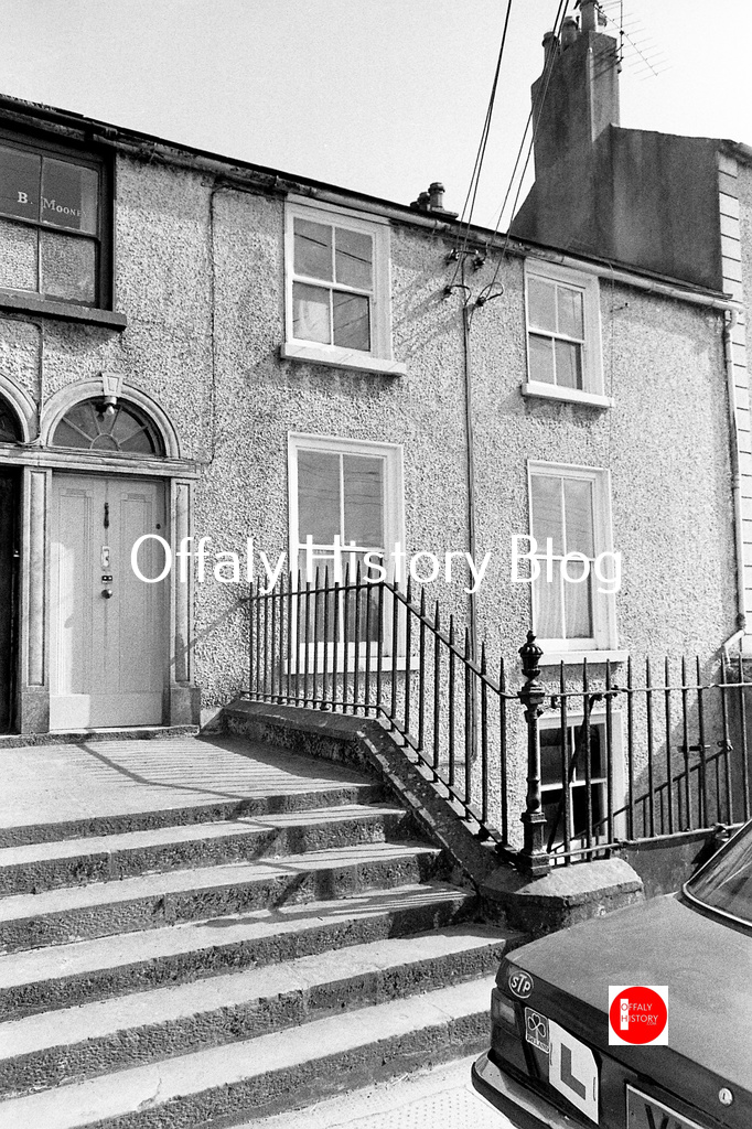
[This house was vacant in 1854 and is one of the two over basement with a common entrance to nos 5 and 6.]
George Pierce M.D. to be let – basement
D.28, H.15.6, 1B wants £20 a year rent – L.R. [17.0.0]
5. (500) [Mathew Knaggs in G.V.P.V 1854].
(Mr Murray) – basement
George Pierce M.D. to be let
D.27, H.15.6, 1B wants 20.0.0, L.R.17.00
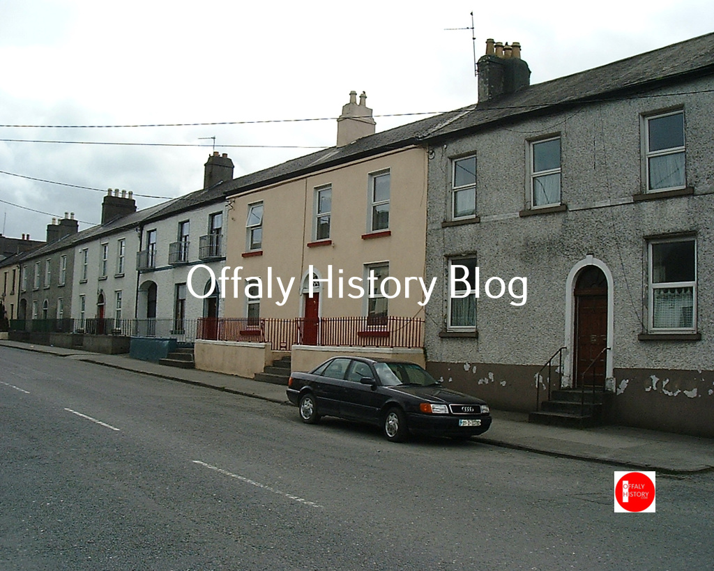
[These are the two-storey over basement houses sharing a common stepped entrance (see photograph]
4. (501) George Pierce M.D. to be let
D.F.33.6, H.20.6, Q.L., 1A and basement
3. (502) George Pierce M.D. to be let
D.F.32, 20.6, 1A quality
‘No’s 501 & 502 have [not] been occupied since they were built. Well enclosed and no. 502 has a garden in the rear. These two houses cost £1800 in building – ground rent £5 each.’]
[These are the two very fine houses beside the courthouse, the last one no. 3 in the printed valuation at £21 is now Dentist Delaney. The ground rent that Pierce told the valuers about would suggest that they were built on a new lease and not in fact part of the Windmill plot. Their being vacant for at least ten years would reflect that the 1840s were difficult with a fall in demand for good quality housing. No. 3 was let in 1854 to a Captain Wm Cassan but no. 4 was vacant and perhaps so since it was built in the late 1830s. By the 1860s William Adams had both houses and the family retained them into the 1920s. No. 4 has remained in the extended Adams family.

Next up on Saturday: The people living in Cormac Street in the early 1900s. All the blog articles (650) can be viewed on http://www.offalyhistory.com. You can get them on email every week by joining the email list. We welcome articles, stories and pictures to illustrate – info@offalyhistory.com
In September-October we publish two articles on the jail, two on the courthouse, the Connaught Rangers, the Foresters and a series on Birr’s Emmet Square and tourism in Kinnitty.
