The young Arthur Fisher from Annagharvey was at the age of twelve in 1880 apprenticed to Archibald Warrren, the Church Street draper (where Salter’s shop was later located) and could recall many years later (c. 1949) coming into Tullamore that day with his mother to begin his five-year term. At the end of the fifth year he would receive £5 and in the meantime live over the shop with bed and board. The town he recalled was built on the river and Grand Canal. He went on to describe the entry to the town from the Geashill Road-Portarlington via Cloncollog.
The four main streets meet in the shape of a cross. The Charleville Hotel occupies a prominent position at the cross streets near the bridge. Entering the town from Portarlington direction, on the right, stands the beautiful Church of Ireland, on Hope Hill, now called Hop hill. It has a beautiful bell that can be heard on a calm day, a distance of four miles. The hill is well wooded with containing walls on the top and sloping grass banks to the road. The carriage drive sweeps around the hill to the west entrance of the church, but a flight of stone steps from the town side, made it pleasant to watch from above, a steady stream of well-dressed people ascend the winding steps. Canon Craig [d. 1904] the rector, was a very, simple, approachable man, but a very poor preacher. As one entered the town over the bridge, there was the Grand Parade [Bachelors Walk]. A new road just made, which was considered the Lovers walk of the town. It ran into Church Street on the left at right angles. The first houses to notice were the Charleville School on the right and the County Infirmary on the left. The pig and meat market came next. Mr Warren’s shop was just beyond the entrance to the shambles and Market Square.[1]
From the earliest times the parish church of Tullamore was located at the old monastic site at Durrow. This remained the situation until c. 1800. Funds were allocated to raise Tullamore to a rectory independent of Durrow. The new parish church at Hop Hill followed in 1815.
The old church in what was then Church Lane remained in use until the opening of St Catherine’s church in 1815. The new church can be seen at the foot of Church Street. Beside the old church was said to be a cemetery and it was presumably here that some early members of the Moore family were buried, including the first Lord Tullamore (if not at ancestral Croghan). William Lumley in a speech at the opening of the new Methodist church in 1889 (also in Church Street and blog article to follow) recalled being told that the former Episcopalian church was on the other side of Church Street where the Shambles was subsequently placed after 1820. Also that the graveyard was exactly opposite the Methodist church and that his old informant could recall seeing the clay and even the bones of the dead carted away and spread on the fields for top-dressing and that close by was an oak tree plantation. It is said that some tombstones were found in Market Square in the nineteenth century. In 1940 a portion of a tombstone was recovered in repair work and some members of the council referred to the local belief that part of the Market Square had once been used as s cemetery.[2]
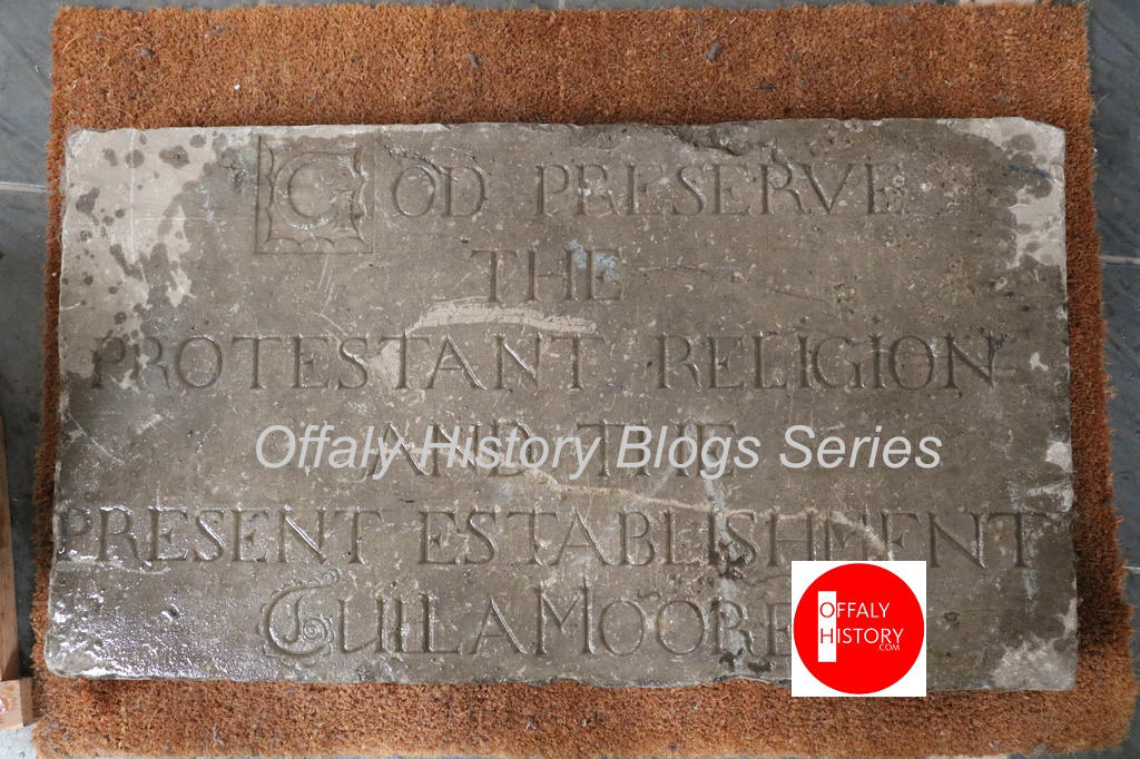
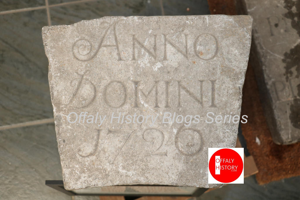
These may have included memorials to Mrs Ellen Moore who funded the 1726 church and other members of the family. Nonetheless the fact that nothing now survives of the old church except the date-stone and the fine Van Nost memorial to Charles Moore, first earl (first creation) who died in 1764 is surprising.
John Wesley we know saw the monument soon after its completion. (See previous blog article.) O’Neill Daunt in his memoir (published in 1896) who was born in Tullamore and lived in what is now Farrellys in High Street) tell the story of a rather shocking interruption to the quiet in the Protestant church in the eighteenth century.
There was a bow-legged lady who, one fine Sunday evening, asked my grandmother, then a girl in her teens, to accompany her to church. Away they went, and when near the church, a huge unruly sow bolted right between the lady’s legs, lifting her off her feet. She could not have kept her seat if her young companion had not held her fast by the arm, racing smartly along to keep pace with the pig. The animal, if I recollect aright, took its course through the open door, up the aisle, and in this unprecedented fashion was the rider borne to her devotions.
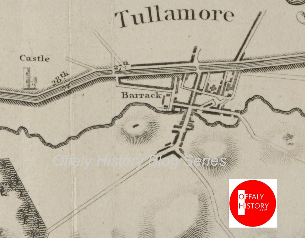
Church Street did not extend any further than the old church until the erection of a factory building by enterprising linen merchants in 1754. This factory was located opposite the later county infirmary building of 1788 (now Library Hall) at the turn for O’Carroll Street. The bridge beside the former bacon factory, now known as Pound Bridge was erected in 1795, opening up the street for traffic from Geashill and reducing Tanyard Lane traffic. Until that time the street was not much more than a lane and was sometimes referred to as such.

Building leases for the lower half of Church Street date from 1786 and 1790, but as in Patrick Street these may be new leases on the site of old poor quality housing. The upper half of Church Street is wider and leases for it date from 1790 on the north side and on the south side from 1805. Francis Johnston, the architect, was responsible for the design of upper Church Street. Johnston was visiting Tullamore at the time in connection with the building of Charleville castle. Most likely, he decided on the width of the street and the size and height of the terrace between the Methodist church and the county infirmary. Most of the houses below the recently vacated Charleville School at the junction with O’Carroll Street were built after 1840 and marked the end of development in the town until the 1900s. As with the bungalows built on the approach roads to Tullamore in the 1940s the scale was modest.
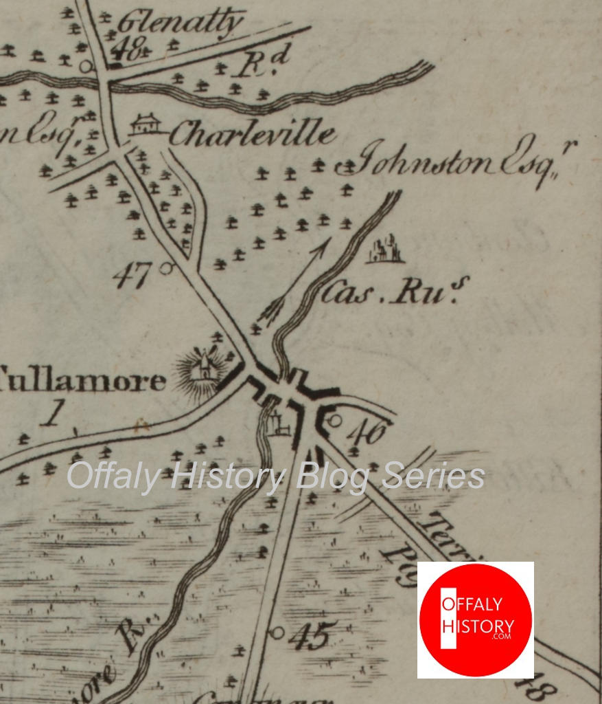
The landlord, Charles William Bury had reserved the large distillery plot for a new church from about 1800 to 1806 but this was built at Hop Hill instead and completed in 1815. Soon after the old church off Church Street was demolished and the site of the church and, it appears an adjoining graveyard, was converted as to part into the Shambles and the remaining land incorporated into the new market square or corn market.
In summary:
Tullamore first Church (C. of I.), Church St N. (635958, 725090[JM1] ). Built in 1726 (datestone at Offaly History Centre); ‘at the sole expense of Mrs Moore, grandmother of the present, the second Lord Tullaghmoor’ 1733 (G. Craig Historical Notes). Depicted 1730 (Moland 1730[JM2] ). The building was of no particular architectural interest according to Atkinson, in his tour of Ireland c. 1810, p. 72.
The church was also depicted 1777 (Taylor and Skinner maps), 1806 (Canal survey by John Killaly for the Grand Canal Company). Closed, congregation transferred to new church in 1815, Old church demolished, built over by shambles or meat market by c. 1820 (G. Craig Historical Notes).
[1] Diary of Arthur Fisher, copy with OHAS and to be published.
[2] OI, 9/11/1940.
