Very soon now Tullamore will have a new Aldi Store at Tay Lane/O’Connell Street, Tullamore. This is the company’s second store in the town/The first was opened in 2000 at Cloncollog and preceded Tesco in 2004 (who once occupied the adjoining Tay Lane site and are near neighbours of Aldi at Cloncollog). Lidl and Dunnes already have two stores each in Tullamore and now Aldi will join this grouping with an investment in Tay Lane of close on €20 million when all expenses are taken into account.

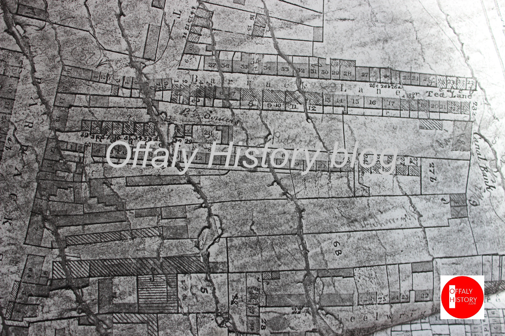
Tea Lane (‘Tay’ Lane) is a popular old street name in Tullamore and most people seem to know that it was the area from the Al Conroy Printing Works (now again Stella Press under Brian Conroy) as far as the Offaly History Centre on the corner of Bury Quay and the former bonded warehouse (the Tullamore DEW Old Bonded Warehouse, 2000–20) and since December 2022 the Old Warehouse bar and restaurant (proprietor Shane Lowry). The name was in existence as early as 1821. The northern part of the lane was called the Old Fair Fields on a 1791 lease map. More changes are now in hand with the opening of a new Aldi store in late November 2024, following on the demolition of all the Irish Mist warehouses (erected from 1970 to 1985) and the great oats store of 1929. Irish Mist and Williams constituted the third layer. The first was that of long gardens from Patrick Street to almost the canal bank and before the canal (1801) the old fair fields. The second was the Williams buildings on these lands post 1897 and before their demolition for the new Irish Mist buildings of 1970-1985. Now Aldi will provide the fourth layer.
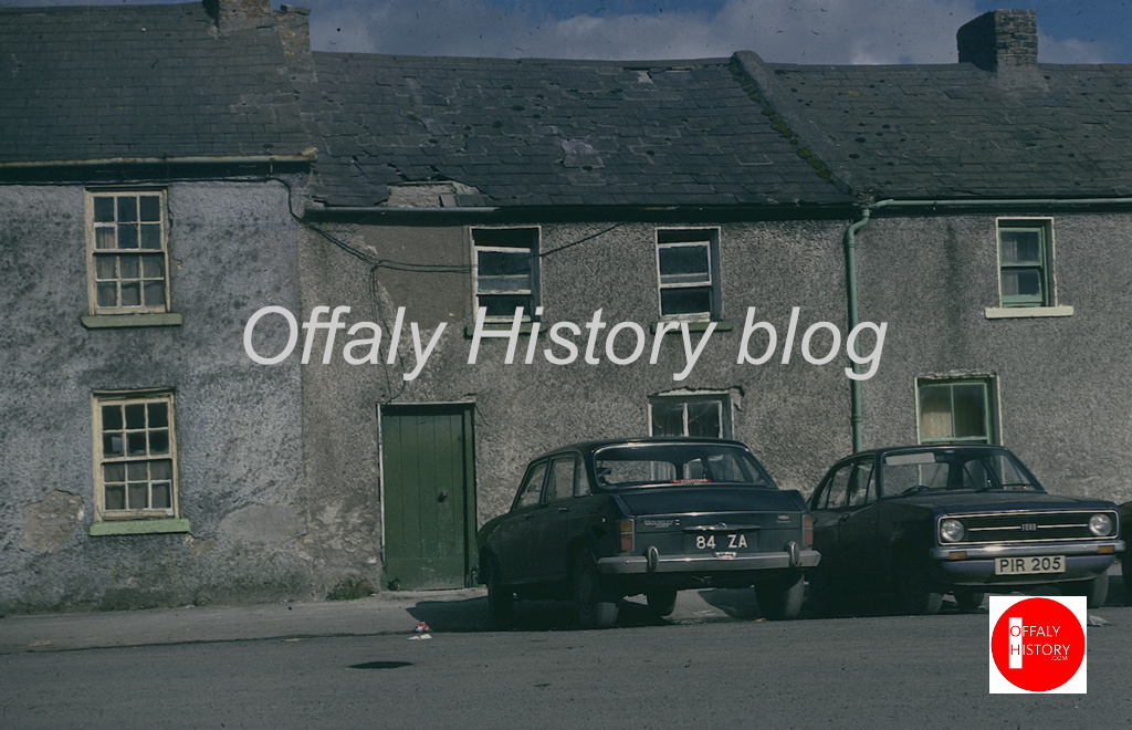
Tea Lane is just one of many residential streets that have been ‘lost’ and were seldom photographed. We rely now, among other sources, on the word pictures in the census of 1901 and 1911 not just for Tea Lane but others such as Swaddling Lane, Gunnood’s Lane, Milestone Lane, Pensioners Row, Tinkers Row, O’Neill Place, Wellington Barrack, Baldwin’s Lane to name only a few. The study of street development and housing in Tullamore from the 1800s to the 1960s and, indeed, to 2024 is a fascinating one in which the private speculator until the 1870s and again from the late 1960s has played a strong part. In the meantime the urban council came strongly into the picture from 1902 and was soon the town’s principal landlord.

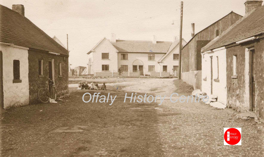
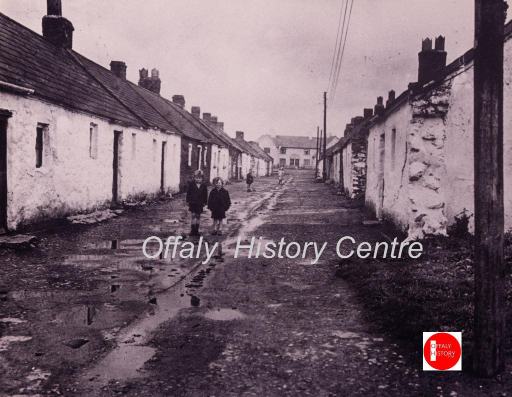
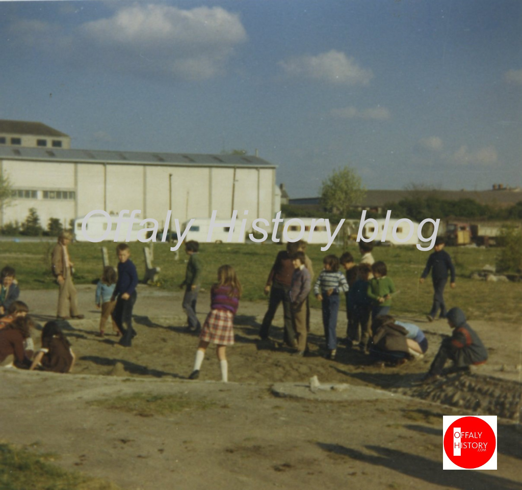
Nowadays Tea Lane bears no resemblance to what it looked like about 1950 and before the demolition of the houses. Most of it now serves as a valuable car park for Tullamore town and income provider for the local authority. It was not always so. At one time the place teemed with people and houses. The purpose of our series of articles is to trace the evolution of the street from the period of remarkable growth of Tullamore in the 1780s and 1790s to the 1820s, to be followed 100 years later by lane clearances. This process continued into the 1950s following on the completion of the new housing estates by the council at Clontarf Road, Marian Place and Pearse Park. The problems of poverty and non-existent sanitation loom large in the story of housing in Tullamore from the Famine to the Free State and up to the 1960s.

What’s in a name? A lot.
The street-name is an example (of which there were many in Tullamore) with two and three names in use over the period since the 1800s. The first names were Barrack Lane and Tea Lane and were used at least as early as the 1820s and since. Tea Lane is a popular street-name in Irish towns, but by the 1870s the east side of Tea Lane was known as O’Connell Row (in honoun of Daniel O’Connell) and this name was adopted by the urban council in the early 1900s when a review of the names of the streets was carried out at the behest of the Gaelic League and as part of Douglas Hyde’s advocacy of the de-Anglicisation of Ireland.
O’Connell Street Tea Lane 1821 (mentioned in Faulkner’s Dublin Journal in a report on the 1821 census. FDJ). Barrack Lane 1838 (Ordnance Survey). Barrack Lane with Tea Lane as to part nearest the canal c. 1854 (Valuation 2). O’Connell Row as to the eastern side of the street and Tea Lane for the western side 1890 (OS); O’Connell Street 1912 (OS). The street from Grennan’s Butchers (2024) to canal bank, dates to 1790s and was best known as Tea Lane/ ‘Tay’ Lane. The reference to O’Connell is probably post 1850. In the Tullamore Deaths civil registers the name Tea Lane continued in use until 1891. The name change to O’Connell Street/Row was probably related to the new Ordnance Survey maps of 1890 and the fact that part of the street to the east side was now officially called O’Connell Row, but O’Connell Street was also in use and continued to be. Surprisingly, in the voters’ registers up to the 1950s the place was still called Barrack Lane. And so the student of this lost street may search under Tea Lane, Barrack Lane, O’Connell Street and O’Connell Row.

Benchmarks for Tea Lane, 1794-2024
Researching the story of Tea Lane was assisted by benchmarks occurring over its 160 years of housing and 220 years of development as follows:
- The first is the grant of the lease for building in the early 1790s and the building of about 50 houses on what became the Morley, and later Belton estate.
- Second, the census return of 1821. There is a surviving summary by street but no more.
- Third, the valuation records of the 1840s and 1850s
- The fourth is the unique source in Tullamore town of the sale of Tea Lane in the Encumbered Estates Court in 1856.
- The long and uneventful second half of the nineteenth century is brought to a close with the review provided by the first surviving census for Tullamore of 1901 and its companion of 1911.
- The clearance of the street in the 1950s can be seen in the context of the Gibney plan for the Kilbride Street area and the new housing before and after the Second World War. This was a very grand planning statement commissioned by the council from Frank Gibney in 1950. Had it been complied with we would now be living in a model town.
- The stop-go policies for the area around Tea Lane and ‘The Quarry’ (between Kilbride Street and the canal) since then reflect public ownership and changing priorities since the 1950s, highlighted in the last fifty years with the playground, car park, through road from Columcille Street and an arts centre site proposal until revoked in 2015.
- Mention should be made of the acquisition of the former Five Star supermarket lands and the Irish Mist property over the period from 1998 to 2007 by property developers for a planned supermarket and shops. This proposal on which perhaps €55 million was spent collapsed with the recession from 2008 and the site lay dormant and derelict until 2023 when half of the site was acquired by Aldi and the other half is awaiting fresh development proposals following rejection by the local authority and the Planning Board of the first application.
- The latest phase is the opening of an Aldi supermarket on the site of Irish Mist Liqueur warehouses planned for 28 November 2024. The principal access to this development is via Tea Lane/O’Connell Street with pedestrian access from Offally Street, Bury Quay and to Columcille Street.
Memories of ‘Tay Lane’ have been gathered by Cecilia Warren and next week we are pleased to have her research and the memories of her mother Josephine Warren.