This year for the walking tours we move to Patrick Street and Church Street on Saturday 5 July, and to the ‘canal quarter’ on 12 July taking in Harbour Street, Store Street, St Brigid’s Place, the Harbour and O’Carroll Street. All are welcome. Admission is free. Wear high viz is helpful. The details are as follows:
5 July, Saturday morning from 11 to 12 30 p.m. Walking tour of Tullamore town: Patrick Street and Church Street with Michael Byrne. Explore the history of these old streets dating back to the 1700s, from the military barracks of 1716 to the church of 1726, county hospital of 1788, the Methodist chapels (4) and the families and shops over 250 years. Find out what is left of the old barracks; where was Swaddling Lane and Pike’s Lane, the linen factory. Who was the Henry in Henry Street – and so much more.
We can meet outside Offaly History Centre, Bury Quay (beside Old Bonded Warehouse restaurant) for ease of parking from 10 45 a.m. All are welcome and the tour is free. Teas/Coffee and bathrooms available from Offaly History Centre from 10. 30 a.m. A big welcome to Birr IGS members who are planning to join the tour.
12 July Saturday morning from 11 to 12 30 p.m.Walk around Harbour Street, Store Street, St Brigid’s Place, the Harbour and O’Carroll Street with Michael Byrne. We can meet outside Offaly History Centre for ease of parking from 10 45 a.m. All are welcome and the tour is free. Coffee and bathrooms available from Offaly History Centre from 10. 30 a.m. Tea and scones available.


Patrick Street (formerly Barrack Street) is in the heart of old Tullamore and may be the oldest street in the town. It was here that the army barracks was built in 1716, to become a police barracks in 1899, burned in the Civil War in July 1922 and a new garda station and housing in the 1920s to the 1950s. The street has a mill and malt houses, but no institutional buildings save for about 25 years a small Methodist preaching house in Swaddling (now Bride’s) Lane behind the two Italian restaurants.
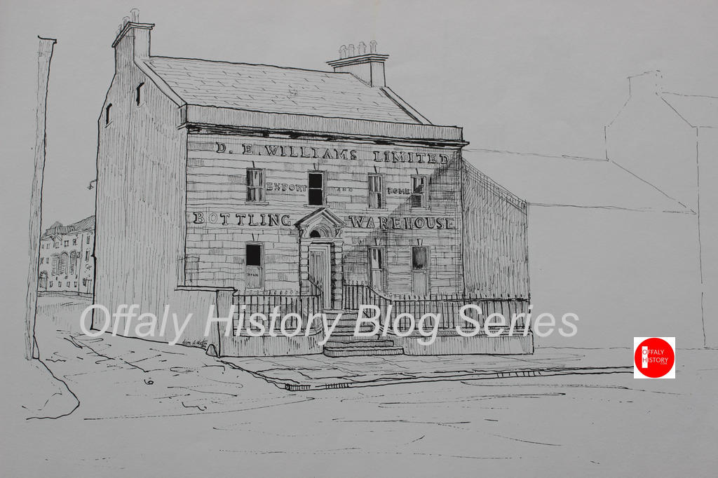
The street is associated with the balloon fire of 1785 when up to 100 mostly thatched houses were destroyed, but at least four survived. These would have included the later Williams head office and the house that was on the site of the later Dunnes Stores (now Elvery’s).
Patrick led on the northwest side to a kind of Irishtown of cabins and low quality houses in Tea Lane, Kilbride Street and Milestone Lane. On the east was the hotel of 1785 or earlier (now Boots) and the old church of 1726 in Church Street. Bridge Street and High Street began to take shape from the 1720s and the square from the 1740s.
Patrick Street is said to be the best trading street in Tullamore for the last 100 years at least and more pronounced from the 1960s when it had Dunnes Stores and Williams supermarkets.
Church Street was no more than a laneway in its early years and its principal building was the Protestant church (1726) in the area that served as the Shambles from 1820 and was later the Country Market and Bracken’s/McCann’s. The oldest part off the street is to the west from the access to what is now Market Square to the junction with William/Columcille Street.

The street was widened from near the present Methodist church in about 1788 and the new bridge on the river completed in about 1795. There are no lanes on the southern side of the street because there was no access to the lands across the river (save behind the present-day library) and the southern side backed on to the Tullamore River.
East of the two churches was the fairgreen in the vicinity of what is now O’Carroll Street, formerly Henry St.
The northern side of the street has varying dates with the church of 1726 the earliest building and joined in 1924 by the Foresters’ Hall, and in the 1980s and 1990s by the new Unity Hall and the Chinese restaurant.

Institutional buildings were five in number when one includes the public Inn:
- The first Protestant church in Tullamore of 1726 and out of use from 1815.
- The Methodist church of 1889 is on the site of not one but two earlier Methodist churches that of 1788 and that of 1814.
- The County Infirmary (now Library Hall) of 1788 and in use as a public library from c 1942 to 1977 or 35 years.
- The former Charleville School of 1811.
- The Tullamore town hotel of 1785, known as Doherty’s by 1800 and for many years as Hayes’ Hotel (demolished in 200o to make way for what is now Boots Pharmacy). It was a public building in that it served the public and survived for almost 215 years. It may have been older but we can consider that later.
All the public buildings have now gone out of use for their intended purpose save the Methodist church where the same site is still in use but in the third building on the site. With five public buildings in use the street and the market in Market Square Church Street was an important thoroughfare at least up the coming of the one-way traffic system in c. 1964 and the restricted parking.

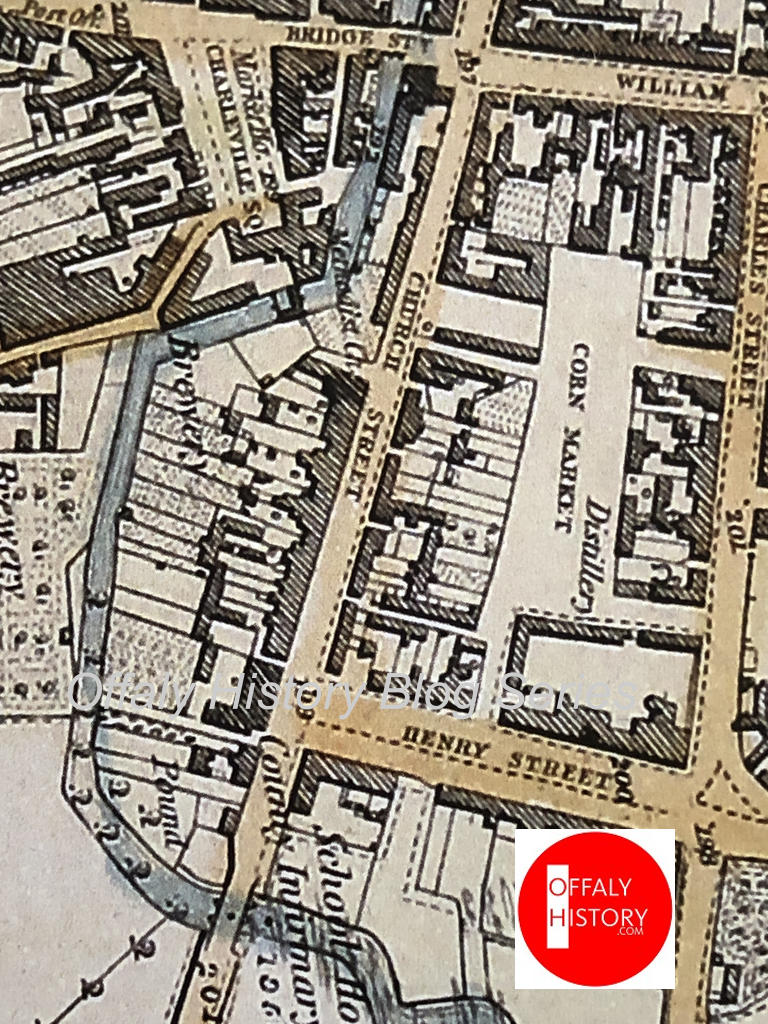
The canal quarter of Harbour Street, Store Street, St Brigid’s Place, the Harbour and O’Carroll Street were ‘new streets’ associated with the arrival of the Grand Canal in 1798 and the economic development that came in consequence. The canal stores were built in 1800 and the harbour at the same time. So too was the embankment leading into the harbour. The latter built on or close to the site of Lord Charleville’s old house before the family moved to Redwood, renamed Charleville in 1740. O’Carroll or Henry Street was the last to be built in the 1830s. The old county hospital of 1788 closed off the vista at its western end and on its west side was the great new distillery of 1822. Behind that was the new market square and from 1860 the gas works.


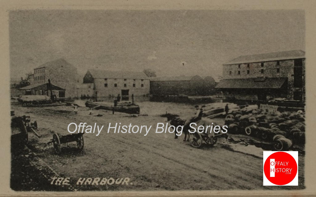
Table 1: The population of Patrick St etc, Tullamore (catchment walking tours only) and the number of thatched and slated houses, 1821 and 1901. The number of the houses and the population was largely settled over the eighty years 1821-1901.
| STREET | POPULATION | HOUSES 1901 | ||||
| 1821 | 1901 | 1821 | Th. | Sl. | TOTAL | |
| Patrick Street/Barrack Street | 302 | 169 | 34 | 38 | 38 | |
| Canal Harbour | 2 | 1 | 1 | |||
| Harbour Street | 200 | 197 | 37 | 40 | 40 | |
| O’Connor Square (excludes 4 in O’Connor Sq West) | 89 | 61 | 10 | 12 | 12 | |
| Church Street* | 327 | 293 | 54 | 51 | 51 | |
| O’Carroll Street | 162 | 23 | 23 | |||
| Market Lane/Pike’s Lane | 55 | 39 | 15 | 11 | 11 | |
| Brides Lane/Ruddock’s Lane/Swaddling Lane | 133 | 87 | 24 | 27 | 27 | |
| Store Street | 44 | 1 | 5 | 6 | ||
* Includes those in the public institutions
Th./thatched
Sl./Slated

The 1821 census also included the following streets not found in the 1901 census:
The 1901 data is based on the original returns in the National Archives. The figures are very close to the parliamentary return of 4,639 persons and 837 inhabited houses. The 1901 original returns also indicate the building materials used in each house, the religion of the occupants, and information on the outhouses. The 1901 original returns highlight the congestion in the Tullamore urban area at the beginning of the century, and provide a firm base for discussion of housing and sanitation. The above table indicates that very little change in urban housing density took place between 1821 and 1901. The transformation of the urban landscape began in Tullamore in 1902 when the first council houses were erected. But the changes in the first decade of the twentieth century were slight and consequently the 1901 census was used in preference to the original returns of the 1911 census which are also available at the National Archives. Now also both censuses of 1901 and 1911 can be viewed online.
Table 2: The valuation of the town of Patrick Street etc, Tullamore in 1843-54[1] There were few houses under £5 and therefore not rated in the catchment area below. The only cabins were those in Church Street on part of the hotel garden and 12 in Pike’s Lane (between Church Street NE and Market Square, behind Chinese restaurant).
| STREET WITH CURRENT NAME FIRST FOLLOWED BY THAT IN VALUATIONS of 1843 and 1854 | RV units | HOUSES 1843-54 | ||||||
| 1843 no of units rated | 1854 No of units rated | 1843 Buildings other than dwellings sep rated | cabins | dwellings | Total no of cabins and dwellings in 1843 | TOTAL HOUSES IN 1854. in brackets are rated units other than dwellings | ||
| Patrick Street/Barrack Street | 38 | 36 | 3[2] | 35 | 35 | 34 (2) | ||
| Grand Canal Place/St Brigid’s Place | 2 | 1 | 1 | 1 | ||||
| Canal Harbour | 10 | 12 | 9 | 1 | 1 | 1 (11) | ||
| Harbour Street/Charles Street | 45 | 47 | 1 | 44 | 44 | 44 (3) | ||
| O’Connor Square/Charleville Square[3] | 20 | 12 | 6 | 14 | 14 | 11 (1) | ||
| Church Street* | 55 | 57 | 5 | 4 | 47 | 51 | 52 (5) | |
| O’Carroll Street/Henry Street | 21 | 24 | 1 | 21 | 21 | 23 (1) | ||
| Cornmarket Lane/Market Place[4] | 1 | 1 | 1 | |||||
| Pike’s Lane/Corn Market Lane/Market Lane | 1 | 12 | 12 | 12 | 12 | |||
| Store Street[5] | 10 | 11 | 3 | 7 | 7 | 9 (2) | ||
Th./thatched
Sl./Slated
Offices here are those rated separately and not included with a rated house.
[1] The results for 1843 are based on the first valuation of Tullamore town in 1843 (National Archives, MS 53214/5. The 1854 figures are from the printed valuation of the several tenements in the union of Tullamore (Dublin, 1854), pp 103-28. Included with the town of Tullamore are parts of it in the townlands of Kilcruttin, Puttaghan, Spollanstown and Kilcruttin. These townlands overlap with the town of Tullamore whereas only the plot forming part of the townland of Srah and described as ‘town of Tullamore (part of) is included here. Also excluded is part 113 of the printed valuation being property in the townland of Tullamore near the Church of Ireland church at Hophill.
[2] Includes barracks at no. 17. At p. 117 of the 1854 printed valuation it should read Barrack Street and not Charles Street.
[3] In 1843 four offices in Tanyard Lane were included with Charleville Square as were the four houses on the western side of the square.
[4] The one house here was included with Market Square in 1854.
[5] See pp 108 and 118 of Griffith (1854).

