Church Street is unusual in Tullamore in that it does not have a common width throughout and its lower half, closest to the town centre, is clearly earlier than the upper half from the Methodist church to the Pound Bridge over Tullamore River. While the building pattern is now post 1786 in date it did have at least two earlier buildings in the Protestant church built by Mrs Ellen Moore in 1726. She was the mother of the first Lord Tullamore who died in 1725. Charles the second Lord Tullamore succeeded while still a minor, having been born in 1712.[1] In an earlier article we reproduced maps from the 1770s depicting the church and noted that the building was shown on the on the 1730 Mountrath (Coote) estate map. The church stood in what was post 1820 the yard shown as The Shambles and was not aligned to the later street.[2]

Neither was the building called the ‘factory house’ off the western side of what is now O’Carroll Street. Both buildings are depicted on Killaly’s map of 1806 and the 1869 Leaseholders map (see the images attached) which I believe contains details from the first known atlas of the town of 1786, last seen in 1958 at the time of John Ainsworth’s visit to the estate office in High Street before it closed. It was being cleaned out in connection with the forthcoming sale of the building. It was Kilroy’s television showrooms from 1960 and is now part of the Mr Price property in High Street. Ainsworth compiled a catalogue of records and listed tenants but had no camera to photograph maps.[3] Possibly a third building pre -1786 building was the inn (later Hayes’ Hotel) which may have been rebuilt or remodelled in 1785-6 by the new landlord Charles William Bury, grandnephew of Charles Moore, the first Moore earl of Charleville who died in 1764.
The lack of the 1786 atlas is a serious loss to the study of the early history of Tullamore. The Killaly map of 1806 was designed to assist the Grand Canal Company and is not a comprehensive map of Tullamore as it stood at that time (see image). For this we have to wait for the 1838 Ordnance Survey town plan on the 5 ft scale and that printed and on the six-inch scale (see images for Church Street).

So what can we say about the plots in Church Street? See the Griffith Valuation map above for the plot numbers.
- GV1 to GV 6 Between Boots Pharmacy and the river on the southern side the Inn plot with an extensive garden backing on the river, let to John Tydd for ever with an inn to the front of Bridge Street and a row of three cabins on the south east side on about one third of the plot fronting Church Street.[4]
- GV 7 To the east of the Inn plot was that of for the Methodist meeting house of 33 ft in front and granted about 1788 in the wake of the balloon fire of 1785 destroying the first preaching house off Barrack/Patrick Street in what was then Swaddling or Ruddock’s Lane and now Bride’s Lane.
- GV 8 to GV 21 Below the Methodist Church was the terrace of 11 plots of 32 ft each in front with gardens running to the Tullamore River. Thirteen houses were built on the 11 plots. See the map of nos 1-3 to land surveyor Michael Cuddehy.
- GV 22 Next came the infirmary on a site provided by CW Bury for which no title was provided. The infirmary was closed in 1921, became a garda station in 1923-37 and was used by the county library from 1942 to 1977. It was sold in the early 1990s by the council/OPW for an apartment development.
- Next are five houses on four sites together with the animal pound.
- On Church St NE were three houses GV 28-31 and what was later the Feehan fowl business adjoining the river. These buildings have lately been converted to a number of small residential units
- Between Henry /O’Carroll Street and the second Market Lane, once called Pike’s Lane were four sites/houses GV 32-36 and on the Pike’s or Market Lane itself 12 cabins. All the property here as far as far as the junction with Columcille Street (but excluding Sterling’s, the Shambles meat market and two sites to Michael Byrne (GV 51–2) – the four sites where the Protestant church of 1726-1815 was located, were not part of the Belton Slater estate. This would be GV 32 to GV 49 and GV 53-57.
Who were the leaseholders and or developers:
First was the landlord C.W. Bury later Lord Tullamore and earl of Charleville (died 1835 when succeeded by the second earl, 1801–51) who was careful about the location of the infirmary and the school. Both were away from the town centre but both buildings determined how the lower side of Church Street and Henry/O’Carroll Street would be developed. The infirmary nicely closed off the vista while the Charleville school block was a prestigious development as was the Flanagan building in O’Connor Square at the junction with High Street and the Acres block at the junction with Cormac Street.

GV 1 Church Street. The earliest record of the Charleville Arms hotel will be found in the lease granted by C.W. Bury to a Mr John Tydd, a gentleman of Tullamore, in March 1786. The hotel is described as ‘ the Inn house with the out offices, yard and garden in Tullamore, measuring in front from the river to Church Lane ( Church Street ) 64’6’’ and in the rear from the garden wall on the North side to the wall adjoining the fair green on the South side 85’6’’ and is 429’ deep from the channel in front to the wall adjoining the preaching house, containing one rood 18 perches plantation measure. Tydd received the usual lease of three lives renewable for ever (virtual alienation by Bury ) on payment of an annual rent of £25 and a renewal fine of £12.10s.0d. On a first reading the size of the head rent comes as a surprise as the more usual figure is £2 to £3. However, this is explained further on when we hear that Bury spent £200 in erecting the inn. The insertion of a covenant that the head tenant ‘shall and will during this demise uphold, maintain and keep the said demised premises in good repair and condition for said purpose and keep a Public Inn theron’ and further that the annual rent will be reduced to £15 provided this covenant is adhered to is restrictive despite the rent abatement. The will of John Tydd was proved in 1798 and that of his son Benjamin in 1799. However, the hotel was sold by Benjamin Tydd, earlier, in April 1796, to Michael Doherty. Doherty agreed to pay £50 annual rent and a renewal fine equal to one half year’s rent thus giving Tydd a profit rent of £35 per annum. Besides the profit rent Tydd retained two thatched houses fronting Church Lane ( the site of the later Bracken’s flower shop and the adjoining house ). It was written into the lease that ‘Benjamin Tydd will have liberty of ingress and regress to thatch the houses partly built on the north side of the garden wall at all proper times.’The hotel later passed to the families of Ridley, Horan, Hayes, Egan, Birr, Spollen in the 1970s and John Flanagan in the late 1990s.

The most significant leaseholder was the Belton Slater family with more than 50 per cent of the sites in the street in their ownership. They were concerned in the linen business and in Church Street near the infirmary was a linen factory from c 1754 owned by Louis Laurent and Samuel Horner. Perhaps the Belton Slaters were connected and went on to have substantial holdings in Church Street.The late Col. F.E. Nangle (born 1910, d. c. 1990) writes that the record below relies to a considerable extent upon the entry in Burke’s 1958 Edition of The Landed Gentry of Ireland. (Entry under Walsh formerly Wilson-Slator).

Unfortunately that entry is inaccurate, said Colonel Nangle, in respect of the Tullamore branch of the family during the 18th century. In consequence the detail given below about George Slator (1721-1772) is in part conjecture based on information from others sources. Further research is necessary before it can be confirmed as wholly accurate. The record starts with:
- Henry Slator of Lislea House, Co. Longford. In November 1659 he married Rebecka Crawford, the daughter of an officer in Cromwell’s army. He died in 1714. They had three sons and two daughters: . .
- George Slator of Kilcommock Co. Longford and Ballynock Kings County was born in 1721. He married Rebecka, daughter of Robert Belton of Ballinamona, near Durrow in King’s County. It is possible that it was at about the time of his marriage that he moved from Co. Longford to Ballynock which is on the outskirts of Tullamore. He died on the 12th June 1772. He had a daughter and two sons:
- Elizabeth who married Thomas Acres of Tullamore in 1790. Acres was a leading property developer in Tullamore . John who married Mary Belton and lived at Coleraine about three miles northwest of Tullamore, He had a son Robert Belton born in 1796 and a daughter Rebecca born in 1797. Robert Belton Slator was a churchwarden of St. Catherine’s Church, Tullamore in 1822 and 1823. He was made a J.P for King’s County in 1849. He was in the linen business in Tullamore and appears to have been a bachelor.
- George (see D below)
- George Slator was probably born during the seventeen sixties. In 1802 he acquired the Wood of O, including some 142 acres of land together with the bogs belonging to them, from Lord Charleville. About the same time he also acquired some houses in [High Street] Tullamore from Lord Charleville [now Hoey & Denning and two houses south of the former Horan’s shop]. In 1804 he married Jane the daughter of Nathaniel Low and they lived at the Wood of O, near Tullamore. In addition to his landed and property interests he was also connected with the linen business in King’s County, together with his nephew Robert Belton Slator. He took an active part in local affairs. In 1806 he was one of a committee of five appointed to superintend the building of the Church of Ireland Church in Tullamore and in 1809 he became a churchwarden. He was a Justice of the Peace and took his duties as a magistrate seriously. In 1811 he received a letter from the former commander of the military garrison in Tullamore referring in flattering terms to his work as a magistrate and thanking him for his cooperation. The following year he received a testimonial from the Court of Directors of the Grand Canal Company formally thanking him for the action he had taken as a magistrate to protect their property. In 1813 a warrant was issued authorising him as a J.P to search for stolen arms in certain parishes in King’s County. He was obviously a man of energy in spite of suffering a certain amount of ill health. He died in the winter of 1822/23 and his widow lived on until 1866. They had four sons and four daughters:
- Nathaniel Robert (see E below)George who died in 1827, under 21 years of age. John who was born in 1818, d.s.p 9th August 1888
- Thomas Francis who lived on a farm called Offaly [Wood of Ophaly] near Tullamore which he inherited from his mother in due course
Robert Belton Slator was baptized at Durrow on the 2nd July 1796 and Rebecca Slator on the 10th September 1797. A snuff box, with an 1848 hall mark and inscribed with the initials R.B.S. is in my [Colonel Nangle’s] possession.

Slaters and Beltons were heavy investors in Church Street and in High Street (five or six properties). Robert Belton of Coleraine, Tullamore got a frontage of 398 ft from the junction with O’Carroll Street to Stirlings east of the shambles (ie near Joe Lee’s pub today). The lease was dated 1790 and this part of Church Street was then called New Street.
The Slater Belton family managed their property and were granting leases and collecting rents thereon up to the 1950s with sales only thereafter.
GV 8-10 Church St (the first three houses after the Methodist church) was leased to Michael Cuddehy, the mapping surveyor in 1803- three sites on which to build according to the Francis Johnston plan.
Next were Darby Hyland, Daniel Warren (all three in 1805) with one house site each followed by Daniel Warren (one site) and George Slater of the Wood of O in 1806, with three sites on which he built four houses. The last two sites in the terrace were leased in 1806 to Daniel Belton and three houses built.
East of the infirmary Mrs Eliza Jordan has a lease in 1825, next was Samuel Woods, the driver to Lord Charleville, and beside the river was Christopher Woods the pound keeper and his family were heavy into tenement properties in Tullamore up to 1900.
On the north side of Church Street were Michael Clooney and Michael Lynam and the school.
The Robert Belton lease followed (see above) and to close off the Market Lane James Stirling had a lease in 1824. The landlord owned the Market Lane, Market Square and the Meat Market in the Shambles. Part of the Shambles was the site of the Foresters’ club and cinema, not built on until 1923–4.
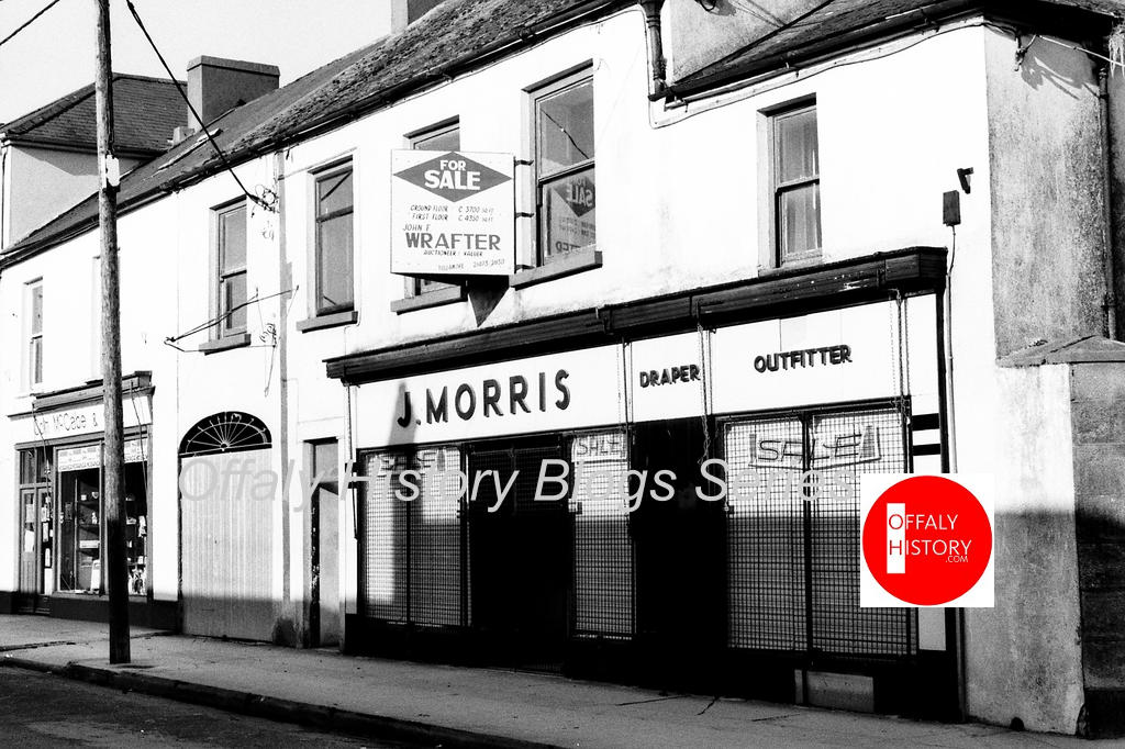
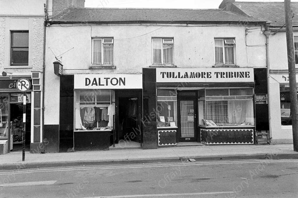
A hardware shopkeeper in William Street, Michael Byrne, got two sites in Church Street (later Morris and McCabe), The rest of the north side to the junction with William Street was a Slater Belton leasehold).
Thanks to the support received from the Heritage Council by Offaly History in researching this article. All contributors to the blogs give their services for the support of Offaly History – a registered charity.

[4] Lease in Offaly Archives.

