The Groome Family of Knockdrin and Garr in the Heart of Uíbh Fhailí
Introduction
Nestled on the frontier of the ancient kingdom of Uíbh Fhailí, beneath the shadow of Croghan Hill, lies the historic townland of Knockdrin—a place long known as the “Hill of Conflict.” For centuries, this landscape formed part of the heartland of Gaelic Offaly, where kings ruled, battles were fought, and generations of ordinary families worked the land and built their lives.
Like many Irish families, the history of the Groomes was preserved through seanchas, the ancient Irish tradition of storytelling. Long before history was written in books, it was carried in memory. Stories of ancestors, local events, victories, hardships and family life were passed from one generation to the next around the warmth of the turf fire by the seanchaí (traditional storyteller), ensuring that the history of a family and its community would never be forgotten.
Seanchas is one of Ireland’s oldest and richest cultural traditions. It is far more than simply telling stories; it is the passing on of memory, heritage, genealogy, folklore and identity. For centuries, it preserved the lives of ordinary people alongside the great events of Irish history, creating an unbroken thread between one generation and the next. It is through this tradition that my own family’s story has survived.
Growing up, I listened to those stories with fascination. They spoke of the Groomes of Knockdrin and Garr, of ancestors whose names were remembered long after they had passed, and of a family whose roots were deeply embedded in the landscape of Uíbh Fhailí. Those memories inspired me to look beyond oral tradition and explore the surviving historical record, comparing the stories handed down within my family with estate maps, parish registers, probate records and other documentary sources. More recently, advances in genetic genealogy, including my FamilyTreeDNA Big Y-700 Y-DNA results, have added another dimension to that research, providing further insight into my direct paternal ancestry.
What emerged was a remarkable story of continuity.
Through manuscript estate maps dating from 1700, 1779, 1803 and 1811, together with family records, oral tradition and modern DNA research, it is possible to trace the presence of the Groome family in the same locality for more than four centuries. These sources reveal not only where my ancestors lived, but also how one family remained rooted in the same landscape despite the immense political and social changes that transformed Ireland from the fall of the Gaelic lordships to the modern age.
This article is more than a genealogy. It is a journey through the history of one Offaly family and the landscape that shaped it. It explores how seanchas, historical records and modern genetic genealogy can come together, allowing family memory to be examined alongside maps, manuscripts, DNA evidence and archival sources. Together, they reveal a story of place, continuity and belonging—one written not only in documents and gravestones, but also in the fields, bogs and quiet townlands of Knockdrin and Garr, where the echoes of the past still endure.
The Ancestry of the Groome Family
The story of the Groome family is deeply rooted in the neighbouring townlands of Knockdrin and Garr, County Offaly. As far as surviving records can tell us, my family has lived in this landscape for more than four centuries. Through the Irish tradition of seanchas, stories of our ancestors, our land and our family were passed from one generation to the next long before they appeared in written records. Those stories inspired me to begin researching my own family history, comparing what had been handed down within my family with the documentary evidence that survives today.
I descend from the Knockdrin branch of the Groome family. Growing up, it was always understood that the Groomes of Knockdrin and Garr shared the same roots. Family gatherings, conversations around the turf fire, and the stories told by older generations all carried the same message: go back far enough, and we were one family, deeply connected to the land on which our ancestors lived and worked.
Like many Irish families, the Groomes did not remain in one place forever. As the generations passed, branches of the family settled in Rhode, Edenderry, Leitrim, Kinnafad and Daingean, while others crossed into County Kildare or moved west towards Castlejordan and Ballinabrackey, where the Groome surname has long been established. Later, some settled in Kinnegad, Mullingar and Dublin, while many more left Ireland altogether for England, Scotland, America and other parts of the world in search of new opportunities and a better life.
Although they built new lives elsewhere, Knockdrin and Garr remained the family’s ancestral home. No matter where later generations settled, these two townlands have always been the place to which our story returns.
One place where that history can still be felt is Garr Graveyard. My grandfather, Patrick “Paddy” Groome, often spoke of an old Groome headstone that he believed dated from the seventeenth century. Today, many of the older gravestones have been weathered by centuries of Irish rain and frost, their inscriptions slowly disappearing beneath lichen and time. Yet the surname Groome can still be seen throughout the graveyard, standing as a quiet reminder of the generations who lived, farmed and were laid to rest within this community.
Among the surviving memorials is the headstone of John Groome of Garr, who died in 1783. Many other Groomes lie buried there beneath stones whose inscriptions have long since faded, while countless others rest in unmarked graves.
Walking through the graveyard today, it is impossible not to wonder about the lives they lived, the hardships they endured, and the stories that disappeared with them.
My own direct paternal line can be traced through my grandfather, Patrick “Paddy” Groome (1934–2015), his father Martin Groome (1900–1970), his father John “Jack” Groome (1866–1947), and his father Martin Groome (1808–1885), my great-great-great-grandfather. Together, these generations lived within the same landscape that had been home to the family for centuries, preserving an enduring connection with Knockdrin and Garr.
Beyond Martin Groome, born in 1808, family tradition remembers three earlier generations of men bearing the same name, each said to have lived in Knockdrin. Those stories remain an important part of our family’s seanchas—a living tradition that preserved memory, ancestry and identity long before family history was written down.
Together, family tradition, surviving records and the remarkable series of estate maps explored throughout this article tell a story that reaches far beyond genealogy alone. They reveal generations of one family connected to the same fields, the same roads and the same townlands despite centuries of political change, social upheaval and emigration. For me, the history of the Groomes is, above all else, a story of home—a story of family, place and belonging that continues to live on in the landscape of Knockdrin and Garr.
Map Manuscripts of Garr and Knockdrin
The 1811 Estate Map: A Family Still Rooted in Knockdrin
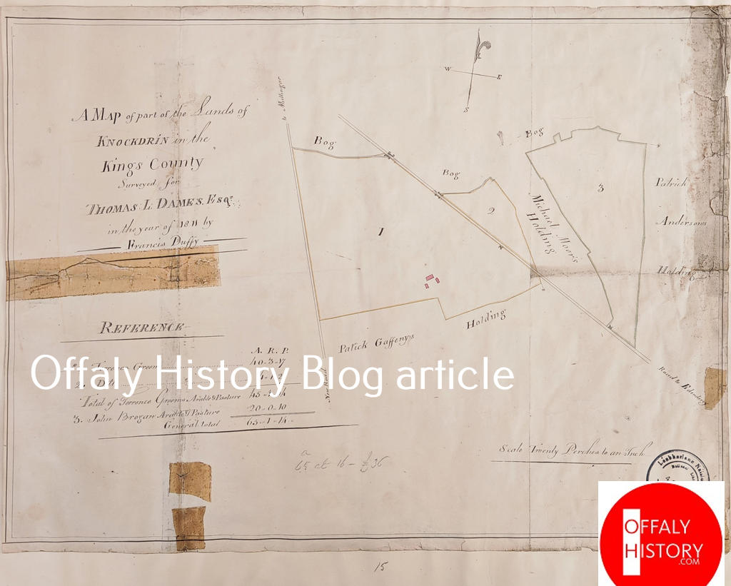
Figure 1. Estate map of Knockdrin, surveyed by Francis Duffy for Thomas Longworth Dames, 27 September 1811.
Among the most valuable documents I have discovered during my research is this remarkable manuscript estate map of Knockdrin, surveyed on 27 September 1811 by Francis Duffy for Thomas Longworth Dames. Beautifully drawn by hand, the map records the fields, boundaries and holdings of the townland with remarkable precision. Every plot is carefully measured in acres, roods and perches, reflecting the importance of accurate land surveys in early nineteenth-century Ireland.
Within the accompanying reference table appears the name Terrence Groom. The survey records him as holding forty acres, together with a further four acres entered separately under the same name. This was not a small or temporary tenancy. A holding of more than forty acres represented a substantial and productive farm, suggesting an established family with deep roots in the locality.
The map was created for practical purposes—to measure land, define tenancies and assist in the administration of the Dames Estate. Yet, more than two centuries later, it tells us far more than the surveyor ever intended.
By 1811, the old Gaelic kingdom of Uíbh Fhailí had long disappeared. The political landscape had been transformed by the Tudor conquest, the Plantation of Leinster, and the seventeenth-century confiscations. Land that had once been governed through Gaelic lordship was now administered through estates, leases and carefully documented surveys.
Despite these profound changes, the Groom family remained in Knockdrin.
There, preserved in ink upon the survey, is the name Terrence Groom, firmly attached to more than forty-four acres of land. It stands as a quiet but powerful reminder that, although the political world around them had changed, the family continued to live and farm the same landscape.
For me, this map represents far more than an estate survey. It marks another chapter in my family’s long association with Knockdrin. It records not simply acres and boundaries, but continuity. Across generations, changing governments and evolving surnames, one thing remained constant: the enduring presence of the Groome family in the heart of County Offaly.
The 1803 Estate Map: A Landscape Preserved in Ink
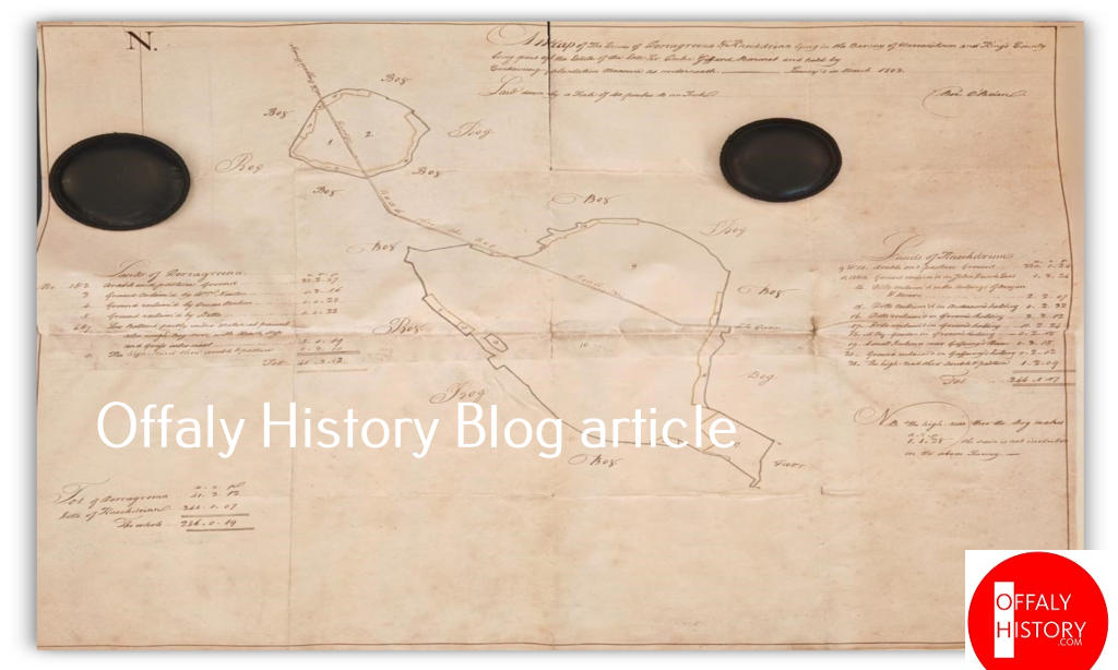
Figure 2. Manuscript estate map of Derrygreenagh and Knockdrin, surveyed in January 1803.
Among the earliest documents that survive for the Garr and Knockdrin area is this beautifully drawn manuscript estate map, surveyed in January 1803. Prepared for estate administration, it records the lands of Derrygreenagh and Knockdrin in King’s County with remarkable care and precision. Every field is outlined, roads wind across the landscape, individual plots are numbered, and the surrounding countryside is simply described as “Bog.” Alongside the map, a detailed schedule records each holding in acres, roods and perches, providing a remarkable snapshot of the landscape as it existed more than two centuries ago.
The survey was never intended to preserve family history. Its purpose was practical: to define property boundaries, regulate tenancies and assist in the management of the estate. By the beginning of the nineteenth century, the old Gaelic lordship of Uíbh Fhailí had long since disappeared, replaced by a landlord system in which land was measured, valued and carefully recorded. Yet today, this map tells a story that reaches far beyond estate administration.
The Groome surname recorded on the map preserves the very landscape in which my ancestors lived and farmed. It captures the fields, roads and boundaries that shaped the world they knew. Looking across the manuscript today, it is remarkable how recognisable the landscape remains despite the passing of more than two centuries.
The importance of this survey becomes even clearer when it is read alongside the estate map of 1811. Together, the two manuscripts reveal a landscape of continuity rather than change. The same farms, the same boundaries and the same pattern of occupation remained in place, demonstrating that Knockdrin and Garr were not places of temporary settlement but well-established farming communities with deep historical roots.
For me, this map represents far more than lines drawn on parchment. It preserves a moment in the history of my family’s homeland. The surveyor intended only to measure land, yet in doing so he unknowingly preserved the setting in which generations of the Groome family lived their lives. The fields he measured, the roads he marked and the boundaries he carefully recorded became the backdrop to my family’s story.
Read on its own, the map is an important estate document. Read alongside the 1811 survey, the parish records and the traditions preserved through seanchas, it becomes something much greater. It forms part of a continuous story that stretches across centuries—a story of family, place and an enduring connection to the land of Knockdrin and Garr.
The 1779 Estate Map: Martin Groom in Knockdrin
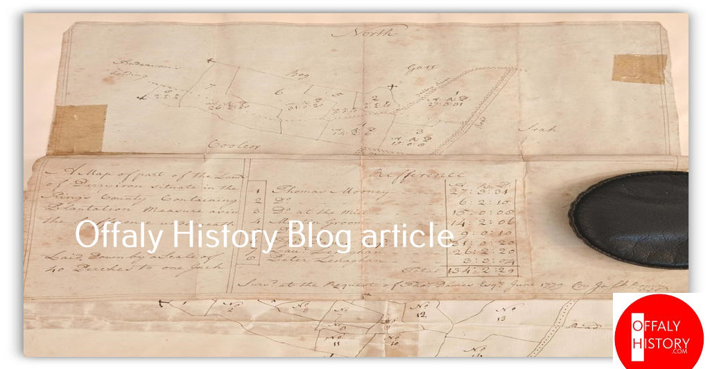
Figure 3. Manuscript estate map of part of the lands of Knockdrin, surveyed for Thomas Dames Esq., June 1779.
Among the most important documents uncovered during my research is this manuscript estate map of Knockdrin, surveyed in June 1779 at the request of Thomas Dames Esq. Drawn to a scale of forty perches to one inch, the survey carefully records part of the townland with numbered fields, clearly defined boundaries, and an accompanying reference table listing each tenant together with the exact size of their holding under Plantation Measure.
More than two centuries later, the map remains remarkably clear. The surrounding landscape is identified by familiar names such as Bog, Gort and Coolcor, while roads, field boundaries and neighbouring holdings are carefully laid out across the page. Although prepared as a practical estate document, it provides a remarkable glimpse into the agricultural landscape of Knockdrin during the late eighteenth century.
For my own family history, however, one entry immediately stands out.
Within the reference table appears the name Martin Groom.
The survey records Martin Groom as the tenant of 23 acres, 2 roods and 16 perches, his holding corresponding to the numbered plots shown on the map itself. This was not a temporary occupation or a casual reference. It represents a recognised and carefully measured tenancy within the estate, demonstrating that the Groom family was already firmly established in Knockdrin by 1779.
The date itself is significant. By the late eighteenth century, the old Gaelic kingdom of Uíbh Fhailí had long since disappeared. The upheavals of the Tudor conquest, the Plantation of Leinster, and the seventeenth-century confiscations had transformed the ownership and administration of land throughout the region. Estates were now governed through leases, surveys and written records rather than the older Gaelic system of lordship. Yet despite these profound political and social changes, the Groom family remained in Knockdrin.
A holding of more than twenty-three acres represented a viable working farm, suggesting permanence rather than transience. Martin Groom’s name appears not as a passing reference but as part of an established agricultural community that continued to work this landscape generation after generation.
For me, this map represents far more than an estate survey. It preserves the name of one of my ancestors in the place where he lived and farmed more than two hundred and forty years ago. The surveyor intended only to measure land and define responsibility, yet in doing so he unintentionally preserved a moment in my family’s history.
Read alongside the estate maps of 1803 and 1811, this document reveals something remarkable. Across more than thirty years, the same landscape continued to be occupied, cultivated and carefully recorded. Together, these manuscript maps illustrate not only the changing administration of land but also the enduring presence of the Groom family in Knockdrin. Measured in acres, roods and perches, they record property; read across generations, they reveal continuity.
The 1700 Estate Map: The Earliest Documentary Record of Martin Groome
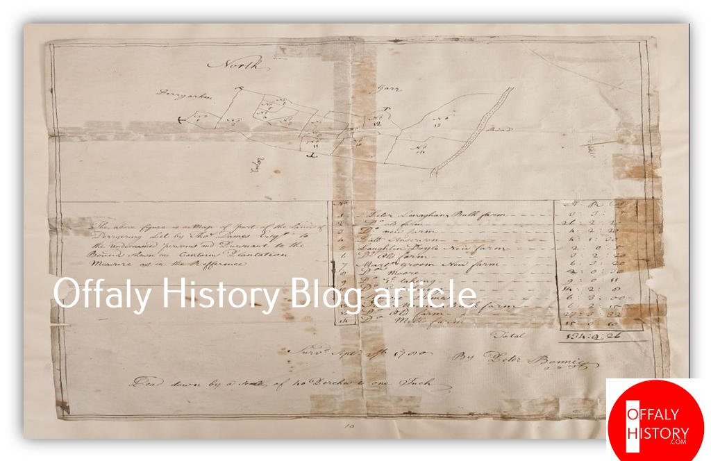
Figure 4. Manuscript estate map of Garr, Knockdrin and adjoining lands, surveyed for Thomas Dames Esq., 27 September 1700.
Among all the documents I have uncovered during my research, none is more significant than this manuscript estate map of 27 September 1700. Surveyed for Thomas Dames Esq., it records the lands of Garr, Knockdrin and the neighbouring townlands within the same estate. Drawn to a scale of forty perches to one inch, the survey carefully outlines the landscape with numbered fields, clearly defined boundaries and an accompanying reference table identifying each tenant together with the extent of their holding under Plantation Measure.
For my family, one name immediately captures the eye.
Within the reference table appears Martin Groome.
He is first recorded as holding a “New Farm” consisting of 6 acres, 3 roods and 20 perches. The survey then continues with three further entries marked “Ditto,” showing that the additional lands belonged to the same tenant. These consisted of a moor containing 2 acres and 30 perches, a first taking of 9 acres and 11 perches, and a second taking of 14 acres and 2 roods. Taken together, Martin Groome’s holding amounted to 32 acres, 2 roods and 21 perches.
This was not a small tenancy. A holding of more than thirty-two acres represented a substantial working farm, combining cultivated land with additional grazing and moor. It reflects a settled and productive agricultural holding at the very beginning of the eighteenth century.
The description “New Farm” is particularly interesting. While its exact meaning cannot now be known with certainty, it may indicate a newly established tenancy or a recently organised farm within the estate. Whatever the reason for the description, the survey leaves no doubt that Martin Groome was recognised as the tenant responsible for a significant holding.
The date itself makes this document especially valuable.
The survey was completed in 1700, within a generation of the Williamite Settlement and only a few decades after the Cromwellian confiscations—events that profoundly altered land ownership throughout County Offaly. The older Gaelic order of Uíbh Fhailí had given way to a landlord estate system in which land was carefully measured, valued and recorded through written surveys such as this one.
Yet despite these enormous political changes, the Groome family was already established in this landscape.
Martin Groome’s name is written clearly in the reference table and linked directly to the numbered plots shown on the map. For me, this represents the earliest surviving documentary evidence placing my family in the Garr and Knockdrin area.
It provides a firm historical anchor, connecting one of my ancestors to a precisely measured holding at the beginning of the eighteenth century. What makes this map even more remarkable is what followed. The estate surveys of 1779, 1803 and 1811 continue to record members of the Groom family in the same locality. Read together, these manuscripts reveal remarkable continuity across more than a century. They demonstrate that while governments changed, estates were reorganised and Ireland itself was transformed, the Groom family remained rooted in the same landscape.
The surveyor who drew this map intended only to measure land and record tenancy. Unknowingly, he preserved something far more enduring. More than three hundred years later, this manuscript stands as the earliest surviving documentary witness to my family’s long association with the lands of Knockdrin and Garr—an association that continued through later generations and remains part of our family’s story today.
The Legacy of My Great-Grandfather
My great-grandfather, Martin Groome (1900–1970), belonged to a generation that witnessed Ireland change forever. He lived through the struggle for independence, the creation of the Irish Free State, the birth of the Republic of Ireland, and two World Wars. Like many Irish people of his generation, he believed that Ireland’s story was not yet complete while the country remained divided.
Growing up, one story was told more than any other around the warmth of the turf fire.
During the War of Independence, Martin and his comrades were said to have helped rescue republican prisoners from Clara RIC Barracks. Afterwards, they made their way home across the snowy fields and bogs of Offaly until they reached Knockdrin—the place long remembered as the Hill of Conflict.
There, according to our family’s seanchas, they were confronted by the Black and Tans late at night. Thinking quickly, they released donkeys from a nearby gateway to create confusion before a gunfight broke out. Taking cover behind a tree, Martin’s rifle was struck by a bullet, costing him two fingers. He escaped by hiding in a nearby drain before finally making his way home. Martin rarely spoke about his experiences, but his hands told part of the story for the rest of his life.
He survived the struggle, married, raised sixteen children and one stepson, and spent the rest of his life in Offaly. Whenever I think of him, I cannot help but think of Knockdrin itself. For generations, it has been known as the Hill of Conflict. Long before Martin climbed its slopes, others had defended this landscape in their own way. In many respects, my great-grandfather was simply defending the Hill of Conflict one more time. His story reminds me that family history is about far more than names and dates. It lives on through seanchas—the stories handed down from one generation to the next—and through the places where those stories unfolded. For our family, Knockdrin will always be one of those places.
A Lost Name of a Gaelic Dynasty
For generations, my family has preserved through seanchas—the Irish tradition of storytelling—the belief that we were originally Ó Conchobhair Fhailí (O’Connor Faly). According to the stories handed down from one generation to the next, our surname was changed to Groom, later Groome, during the political upheavals of the sixteenth and seventeenth centuries, when the old Gaelic order was dismantled and many members of the O’Connor Faly dynasty lost their lands, were forced into exile, or were transplanted west to Connacht.
Within our family, the surname Groome has always been remembered as an occupational surname. A groom was a man whose work centred on horses—their care, training and management. This tradition has always carried particular meaning because the O’Connor Falys were renowned horsemen. Horses lay at the heart of Gaelic life, whether in travel, hunting, warfare or the running of a lordship. According to our family’s oral tradition, adopting the occupational surname Groome reflected the skills for which our ancestors were long known while providing an English form of surname during a period of profound political change.
One of the most fascinating discoveries during my research was the appearance of the Gaelic byname Giolla Gruama within the Ó Conchobhair dynasty. Unlike a hereditary surname, Giolla Gruama was a Gaelic byname—a personal identifier used to distinguish one individual from another within the same extended family or clan. This was common throughout Gaelic Ireland, where the great dynasties had become so large that the same Christian names appeared repeatedly across successive generations.
Among the Ó Conchobhairs, there were numerous men named Toirdhealbhach (Turlough), Conchobhar (Connor), Cathal, Aodh (Hugh) and Donnchadh (Donogh). A personal name alone was often not enough to identify a particular individual.
To solve this problem, Gaelic society developed the widespread use of bynames. These descriptive names identified a person by appearance, character, achievement or another distinguishing feature. Examples include Rua (“red-haired”), Dubh (“black” or “dark”), Bán (“fair”), Mór (“the great”), Óg (“the younger”), Cam (“crooked”), and Giolla Gruama, a byname understood to mean “Follower (or Servant) of the Stern or Fierce One.”
These were not hereditary surnames but personal identifiers used alongside the dynastic family name. Thus, one man might be known as Toirdhealbhach Rua Ó Conchobhair, while another could be known as Toirdhealbhach Giolla Gruama Ó Conchobhair, each belonging to the same ruling family but distinguished by a different byname.
As English administration spread across Ireland during the Tudor period, these rich Gaelic naming traditions were increasingly simplified. Irish names were translated, shortened or written phonetically by English-speaking officials unfamiliar with the Irish language. In surviving records, names such as Giolla Gruama appear in forms including Gyllegromme, Grome, Groom, and eventually Groome, while the older dynastic surname Ó Conchobhair was sometimes omitted altogether. A man known among his own people as Toirdhealbhach Giolla Gruama Ó Conchobhair might therefore appear in an English record simply as Terence Groome.
It is also important to distinguish between the two names. The English word groom referred to a horse attendant or stableman, whereas the Gaelic byname Giolla Gruama has an entirely different origin and meaning. Although similar in appearance when anglicised, they derive from different linguistic traditions.
Another remarkable discovery comes from the Fiants of the Tudor Sovereigns, where one Tudor Fiant records:
“Edm. Groome m’Donogh M’Conoghor.”
This entry identifies Edmund Groome, son of Donogh Mac Conoghor. Although the surname appears in its English form, the record preserves an unmistakably Gaelic patronymic structure, directly linking Edmund to Mac Conoghor. Rather than appearing as an isolated English surname, the entry places the name Groome within a clearly Gaelic naming tradition. It is a rare and important documentary reference demonstrating the coexistence of an anglicised surname alongside a Gaelic patronymic during the Tudor period.
The documentary record continues in Knockdrin itself. The manuscript estate survey of 1700 records Martin Groome holding more than 32 acres of land. The survey of 1779 records Martin Groom holding more than 23 acres, while the estate maps of 1803 and 1811 continue to document the family within the same landscape, with Terrence Groom holding more than 44 acres by 1811.
Read together, these remarkable manuscript maps preserve more than a century of continuous occupation in Knockdrin and Garr, demonstrating the enduring presence of the Groome family within the same locality.
Modern genetic genealogy has added another dimension to this story. My FamilyTreeDNA Big Y-700 results place my direct paternal line within haplogroup R-FGC54803, a lineage with deep roots in Ireland. My Y-DNA matches include men bearing the surnames Connor, O’Connor, O’Kelly and McKeown, together with many other long-established Gaelic Irish families. Combined with the documentary evidence and the oral traditions preserved through seanchas, the DNA results provide another important strand in the history of my family.
Viewed together, the evidence forms a compelling picture. The Tudor Fiants, the manuscript estate maps of 1700, 1779, 1803 and 1811, my Big Y-700 DNA results, and the oral traditions preserved within my family each contribute to the story of the Groomes of Knockdrin. Together they trace a family whose roots run deep within the ancient kingdom of Uíbh Fhailí. Preserved through seanchas, recorded in manuscripts, reflected in genetic ancestry and remembered across generations, they tell the story of a family whose connection with the landscape of Gaelic Offaly has endured for centuries.
Pádraig Ó Grúma
References
Calendar of the Fiants of Queen Elizabeth I, Fiant 35 Elizabeth I (1592–1593), Item 5802.
Royal Irish Academy. Electronic Dictionary of the Irish Language (eDIL): Dictionary of the Irish Language Based Mainly on Old and Middle Irish Materials. Dublin: Royal Irish Academy. Available at: Electronic Dictionary of the Irish Language (eDIL) (entries for giolla and gruam/gruama).
National Library of Ireland. (n.d.). Maps of the Dames estate, formerly the property of Sir John Gifford, in the barony of Warrenstown, Offaly, by various surveyors, 1655–1833 (Manuscript Maps Collection, Call No. 21 F 79 (4–19)). National Library of Ireland Catalogue. https://catalogue.nli.ie/Record/MS_UR_025085
FamilyTreeDNA. (2019). Big Y-700 White Paper: Powering discovery in the field of paternal ancestry. Gene by Gene, Ltd. https://blog.familytreedna.com/wp-content/uploads/2019/03/big-y-700-white-paper_compressed.pdf
FamilyTreeDNA. (2025). Big Y-700 Y-DNA results for Pádraig Groome [Personal genetic genealogy results]. FamilyTreeDNA. https://www.familytreedna.com/